TopoQuest Logo
Do you find TopoQuest useful?
Help keep TopoQuest running and adding new maps/features by donating!
Bitcoin:  19c7KJd3qBynnjoSw5npx9KScwjBe4ifkT
Litecoin:  LXs6TkuXGGXo1vDsWCkWVdjQX94eUKd6ui
Home View Maps Find Maps Find Places Resources & Links


Greenwood, Alabama Topographic Map

USGS Map Title: Greenwood, AL
USGS Map MRC: 33086C8
DRG (GeoTIFF) Download: o33086c8.tif


Neighboring USGS Topographic Map Quads:


  Concord, AL  
33087D1
 

  Bessemer, AL  
33086D8
 

  Birmingham South, AL  
33086D7
 

  McCalla, AL  
33087C1
 

  Greenwood, AL  
33086C8
 

  Helena, AL  
33086C7
 

  Halfmile Shoals, AL  
33087B1
 

  Pea Ridge, AL  
33086B8
 

  Alabaster, AL  
33086B7


Map MRC Location:

N34°
W87°
N34°
W86°
H8 H7 H6 H5 H4 H3 H2 H1
G8 G7 G6 G5 G4 G3 G2 G1
F8 F7 F6 F5 F4 F3 F2 F1
E8 E7 E6 E5 E4 E3 E2 E1
D8 D7 D6 D5 D4 D3 D2 D1
C8 C7 C6 C5 C4 C3 C2 C1
B8 B7 B6 B5 B4 B3 B2 B1
A8 A7 A6 A5 A4 A3 A2 A1
N33°
W87°
N33°
W86°

Greenwood, AL USGS 1:24K Topographic Map Preview:
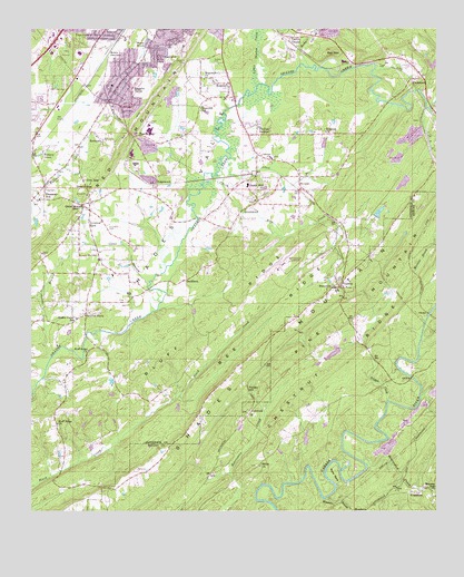
Greenwood, AL USGS Topographic Map
Click on map above to begin viewing in our Map Viewer.

This topographic map contains these locations and features:
Feature Name Type Latitude Longitude GNIS ID View Map
Allen BrookStreamN33.3387°W86.9405°112998View Map
B Mountain LakeLakeN33.3663°W86.8756°143980View Map
B Mountain Lake DamDamN33.3651°W86.8767°131481View Map
BamfordPopulated PlaceN33.2759°W86.9319°156020View Map
Beaverdam CreekStreamN33.2629°W86.8975°154978View Map
Bee MountainSummitN33.3690°W86.9075°113802View Map
Bee RidgeRidgeN33.2923°W86.9333°113803View Map
Bessemer AirportAirportN33.3119°W86.9255°129462View Map
Bessemer Fire Department Station 3BuildingN33.3501°W86.9353°2683455View Map
Bessemer Fire Department Station 4BuildingN33.3564°W86.9990°2683451View Map
Bessemer Municipal Golf CourseLocaleN33.3682°W86.9889°143999View Map
Bessemer QuarryMineN33.3439°W86.9628°2568264View Map
Bessemer State Technical CollegeSchoolN33.3732°W86.9933°144000View Map
Birons FordCrossingN33.3593°W86.9486°144015View Map
Bluff RidgeRidgeN33.3057°W86.9372°114616View Map
Bluff Ridge ChurchChurchN33.2726°W86.9919°114617View Map
Bluff Ridge ChurchChurchN33.2918°W86.9825°114618View Map
Bluff Ridge SubdivisionPopulated PlaceN33.2804°W86.9917°154360View Map
Bob George BranchStreamN33.2901°W86.9942°114634View Map
Brocks (historical)LocaleN33.3537°W86.8758°151317View Map
Canaan ChurchChurchN33.3412°W86.9253°115523View Map
Cherokee BeachPopulated PlaceN33.2929°W86.9078°154322View Map
Cherokee Beach LakeReservoirN33.2912°W86.9064°131404View Map
Cherokee Beach Lake DamDamN33.2918°W86.9050°131405View Map
Chestnut GlenPopulated PlaceN33.2848°W86.9197°154321View Map
Chestnut RidgeRidgeN33.2884°W86.9039°116027View Map
City of BessemerCivilN33.3709°W86.9713°2403864View Map
Clear BranchStreamN33.3084°W86.9639°116214View Map
Clear Branch GapGapN33.3296°W86.9850°116219View Map
CoalmontPopulated PlaceN33.2548°W86.8830°116315View Map
Coalmont MineMineN33.2584°W86.8833°146395View Map
Cow GapGapN33.3357°W86.9792°116751View Map
Dickey SpringSpringN33.3276°W86.9353°144132View Map
Eastern ValleyPopulated PlaceN33.3596°W86.9686°117798View Map
Eastern Valley Volunteer Fire DepartmentBuildingN33.3649°W86.9687°2683180View Map
Eden RidgePopulated PlaceN33.3362°W86.8797°154364View Map
EdgewoodLocaleN33.3348°W86.9611°156298View Map
Fairington CemeteryCemeteryN33.3234°W86.9767°118122View Map
Fox TracePopulated PlaceN33.2779°W86.9453°154369View Map
GeneryPopulated PlaceN33.3087°W86.9039°118888View Map
George CemeteryCemeteryN33.2996°W86.9989°144225View Map
GreenwoodPopulated PlaceN33.3259°W86.9361°119379View Map
Greenwood DivisionCivilN33.3021°W86.9741°165818View Map
Greenwood Elementary SchoolSchoolN33.3346°W86.9330°154362View Map
Greenwood Junior High SchoolSchoolN33.3340°W86.9275°144252View Map
Guytons LakeReservoirN33.3352°W86.8851°131453View Map
Guytons Lake DamDamN33.3368°W86.8833°131454View Map
Helena Fire Department Station 2BuildingN33.2824°W86.8862°2683101View Map
Hickory GrovePopulated PlaceN33.3418°W86.9997°120022View Map
High PointPopulated PlaceN33.3337°W86.8778°154366View Map
HighlandsPopulated PlaceN33.2984°W86.9194°154323View Map
HilltopPopulated PlaceN33.3426°W86.9300°155500View Map
Hillview ChurchChurchN33.3482°W86.9094°120143View Map
Hoover Fire Department Station 6BuildingN33.3515°W86.8752°2555265View Map
HopewellPopulated PlaceN33.3607°W86.9386°120354View Map
Hopewell ChurchChurchN33.3621°W86.9469°120375View Map
Hopewell Church (historical)ChurchN33.3532°W86.9489°144283View Map
Hopewell Elementary SchoolSchoolN33.3543°W86.9475°165452View Map
Indian Ford Volunteer Fire DepartmentBuildingN33.3083°W86.9054°2682805View Map
Janeway MineMineN33.2751°W86.8819°146475View Map
Jess Lanier High SchoolSchoolN33.3687°W86.9853°144312View Map
Johnsons LakeReservoirN33.3273°W86.8926°131441View Map
Johnsons Lake DamDamN33.3268°W86.8943°131440View Map
Laceys ChapelPopulated PlaceN33.3729°W86.9208°121297View Map
Laceys Chapel Elementary School (historical)SchoolN33.3715°W86.9214°144328View Map
Little Shades CreekStreamN33.3601°W86.9308°121885View Map
Lovelace BridgeBridgeN33.2951°W86.9830°144356View Map
Loveless ParkPopulated PlaceN33.3246°W86.9822°122063View Map
Macedonia ChurchChurchN33.3076°W86.9058°122161View Map
Massey CemeteryCemeteryN33.3048°W86.9703°144365View Map
McAdory Fire and Rescue Station 1BuildingN33.3060°W86.9829°2683176View Map
Mobile JunctionPopulated PlaceN33.3682°W86.9767°156723View Map
MorganPopulated PlaceN33.3337°W86.9167°123036View Map
Morgan ChurchChurchN33.3384°W86.9175°1987077View Map
Morgan School (historical)SchoolN33.3384°W86.9175°1987079View Map
Morning Star ChurchChurchN33.2554°W86.8764°123065View Map
Moss BendBendN33.2598°W86.9061°123112View Map
MossboroPopulated PlaceN33.2509°W86.8983°156740View Map
Mossboro BranchStreamN33.2534°W86.9097°123122View Map
Mossburg Number 1 MineMineN33.2543°W86.9000°146522View Map
Owens GapGapN33.3329°W86.9828°124348View Map
ParkwoodPopulated PlaceN33.3623°W86.8794°124457View Map
Parkwood ChurchChurchN33.3654°W86.8819°144447View Map
Parkwood HillsPopulated PlaceN33.3473°W86.8969°154361View Map
Phillips EstatesPopulated PlaceN33.3476°W86.9300°124689View Map
Pine CrestPopulated PlaceN33.3718°W86.9869°124764View Map
Pleasant HillPopulated PlaceN33.3309°W86.9961°124972View Map
Pleasant Hill United Methodist ChurchChurchN33.3307°W86.9972°151318View Map
Potato HillSummitN33.2826°W86.9322°125202View Map
Potter MineMineN33.3640°W86.9589°144478View Map
RaimundPopulated PlaceN33.3679°W86.9614°125414View Map
Raimund Elementary School (historical)SchoolN33.3673°W86.9483°144491View Map
Ray CemeteryCemeteryN33.2826°W86.8986°149350View Map
RicePopulated PlaceN33.3734°W86.9747°125589View Map
Rice CreekStreamN33.3412°W86.9386°125595View Map
RockdalePopulated PlaceN33.3462°W86.9780°125785View Map
Rocky BrookStreamN33.3654°W86.9150°125843View Map
Russet WoodsPopulated PlaceN33.3298°W86.8867°154367View Map
Sadlers CemeteryCemeteryN33.3657°W86.9433°126074View Map
Sargon (historical)LocaleN33.3532°W86.9700°140272View Map
Scott Crest SubdivisionPopulated PlaceN33.2759°W86.9467°154370View Map
Shades MountainRangeN33.2807°W86.9436°126578View Map
Shades RunPopulated PlaceN33.3348°W86.8769°154365View Map
Shades Valley Elementary SchoolSchoolN33.3001°W86.9861°165528View Map
Shady BrookPopulated PlaceN33.3665°W86.9703°126583View Map
Shady Grove ChurchChurchN33.3046°W86.9911°140289View Map
ShadywoodPopulated PlaceN33.3168°W86.8978°154405View Map
Shiloh CemeteryCemeteryN33.2618°W86.9300°146562View Map
Shiloh ChurchChurchN33.2618°W86.9292°126745View Map
SmithsonPopulated PlaceN33.3098°W86.9525°157079View Map
Smithson CemeteryCemeteryN33.3034°W86.9703°140305View Map
SouthpointePopulated PlaceN33.3212°W86.8892°154325View Map
Sparks GapLocaleN33.3473°W86.9667°127169View Map
Summit FarmPopulated PlaceN33.3012°W86.9833°127548View Map
Trigger CreekStreamN33.2787°W86.8900°128071View Map
Twin Lakes Country ClubLocaleN33.3518°W86.9786°140355View Map
UAB Health System Medical West HospitalHospitalN33.3721°W86.9910°144065View Map
Weeping OaksPopulated PlaceN33.3168°W86.8939°154324View Map
Wellington Industrial ParkLocaleN33.3709°W86.9078°154363View Map
Whispering OaksPopulated PlaceN33.3176°W86.8964°154368View Map

Note: Coordinates in the location and feature list above are referenced to NAD83 datum.


Copyright (C) 2008-2024 Ryan Niemi / Sunset Dynamics ... All Rights Reserved