TopoQuest Logo
Do you find TopoQuest useful?
Help keep TopoQuest running and adding new maps/features by donating!
Bitcoin:  19c7KJd3qBynnjoSw5npx9KScwjBe4ifkT
Litecoin:  LXs6TkuXGGXo1vDsWCkWVdjQX94eUKd6ui
Home View Maps Find Maps Find Places Resources & Links


Halfmile Shoals, Alabama Topographic Map

USGS Map Title: Halfmile Shoals, AL
USGS Map MRC: 33087B1
DRG (GeoTIFF) Download: o33087b1.tif


Neighboring USGS Topographic Map Quads:


  Abernant, AL  
33087C2
 

  McCalla, AL  
33087C1
 

  Greenwood, AL  
33086C8
 

  Woodstock, AL  
33087B2
 

  Halfmile Shoals, AL  
33087B1
 

  Pea Ridge, AL  
33086B8
 

  West Blocton West, AL  
33087A2
 

  West Blocton East, AL  
33087A1
 

  Aldrich, AL  
33086A8


Map MRC Location:

N34°
W88°
N34°
W87°
H8 H7 H6 H5 H4 H3 H2 H1
G8 G7 G6 G5 G4 G3 G2 G1
F8 F7 F6 F5 F4 F3 F2 F1
E8 E7 E6 E5 E4 E3 E2 E1
D8 D7 D6 D5 D4 D3 D2 D1
C8 C7 C6 C5 C4 C3 C2 C1
B8 B7 B6 B5 B4 B3 B2 B1
A8 A7 A6 A5 A4 A3 A2 A1
N33°
W88°
N33°
W87°

Halfmile Shoals, AL USGS 1:24K Topographic Map Preview:
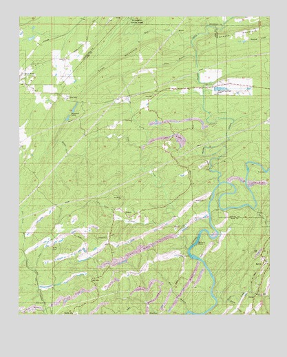
Halfmile Shoals, AL USGS Topographic Map
Click on map above to begin viewing in our Map Viewer.

This topographic map contains these locations and features:
Feature Name Type Latitude Longitude GNIS ID View Map
Bear BranchStreamN33.1268°W87.0408°113635View Map
Belle Ellen Baptist Church (historical)ChurchN33.1271°W87.0633°151013View Map
Bishop CreekStreamN33.1662°W87.0469°114382View Map
Black CreekStreamN33.1321°W87.0261°114420View Map
Booth FordCrossingN33.1854°W87.0019°156098View Map
Brimwood LakesReservoirN33.2120°W87.0971°114919View Map
Camp BoothLocaleN33.2165°W87.1022°115435View Map
Camp Branch Baptist ChurchChurchN33.2071°W87.0689°151712View Map
Camp Branch CemeteryCemeteryN33.2071°W87.0689°1959561View Map
Camp CreekStreamN33.1951°W87.0639°115453View Map
Cane CreekStreamN33.1523°W87.0408°115533View Map
Cane Creek (historical)Populated PlaceN33.1412°W87.0272°1959562View Map
Clear BranchStreamN33.2329°W87.0367°116213View Map
Coal BranchStreamN33.1323°W87.0244°1959565View Map
Coffee Creek Slope MineMineN33.1296°W87.0806°138366View Map
Daley CreekStreamN33.1310°W87.0205°117018View Map
Daly Church (historical)ChurchN33.2062°W87.0028°146403View Map
Dry Ford BranchStreamN33.1479°W87.1219°117601View Map
Evans Rock Slope MineMineN33.1273°W87.0806°138371View Map
Farrars Mill (historical)LocaleN33.2293°W87.1133°148122View Map
Flat CreekStreamN33.1440°W87.1167°118375View Map
Fountain HillSummitN33.1573°W87.0811°118544View Map
GarnseyPopulated PlaceN33.1323°W87.0075°118845View Map
Gray HillPopulated PlaceN33.2162°W87.0578°156431View Map
Gray HillSummitN33.1523°W87.1064°119294View Map
Gray Hill School (historical)SchoolN33.2182°W87.0569°138374View Map
Green Pond Presbyterian ChurchChurchN33.2254°W87.1242°151015View Map
Green Pond Volunteer Fire Department Station 3BuildingN33.2151°W87.0790°2683089View Map
Halfmile ShoalsRapidsN33.1551°W87.0367°119568View Map
Halls MillLocaleN33.2301°W87.0300°163942View Map
HebronPopulated PlaceN33.1673°W87.0672°119919View Map
Hebron CemeteryCemeteryN33.1654°W87.0736°149508View Map
Hebron School (historical)SchoolN33.1740°W87.0922°138376View Map
Hickman Chapel CemeteryCemeteryN33.2334°W87.1017°148222View Map
Hickman ChurchChurchN33.2318°W87.1022°120015View Map
Higganbotham CemeteryCemeteryN33.2173°W87.0255°146463View Map
Lilly ShoalsRapidsN33.1498°W87.0400°121622View Map
Little Cane CreekStreamN33.1654°W87.0755°121729View Map
Locke FordCrossingN33.1654°W87.0300°138382View Map
MarvelPopulated PlaceN33.1468°W87.0030°122348View Map
Marvel ChurchChurchN33.1440°W87.0011°138384View Map
Marvel Water TowerTowerN33.1471°W87.0019°1959575View Map
MasenaPopulated PlaceN33.1618°W87.0436°156665View Map
McCulleyPopulated PlaceN33.1393°W87.0892°152271View Map
McCulley Hill Baptist ChurchChurchN33.1398°W87.0875°154173View Map
McKensey CemeteryCemeteryN33.1726°W87.0372°122569View Map
McKinney CemeteryCemeteryN33.1826°W87.0228°149450View Map
McKnight LakeReservoirN33.2101°W87.0867°131309View Map
McKnight Lake DamDamN33.2101°W87.0867°131308View Map
Middle BranchStreamN33.1982°W87.0897°122682View Map
Mitchell FordCrossingN33.1857°W87.0297°138386View Map
Mount Nebo Baptist ChurchChurchN33.1429°W87.0119°149509View Map
Mud CreekStreamN33.2412°W87.0378°158882View Map
New Hebron Baptist ChurchChurchN33.1737°W87.0744°152626View Map
Peachtree Slope MineMineN33.1296°W87.0825°138389View Map
Saint Mark Catholic Church (historical)ChurchN33.1485°W87.0075°138399View Map
Sand MountainSummitN33.2365°W87.0553°126318View Map
Savage CreekStreamN33.1696°W87.0080°126432View Map
Shades CreekStreamN33.1804°W87.0247°153377View Map
Shady Grove Baptist ChurchChurchN33.2204°W87.0317°153386View Map
Shady Grove CemeteryCemeteryN33.2207°W87.0311°151014View Map
Standiford (historical)LocaleN33.2404°W87.1219°148596View Map
Tannehill ChurchChurchN33.2498°W87.0739°153646View Map
Tannehill Furnace (historical)LocaleN33.2487°W87.0694°148617View Map
Tannehill Mill (historical)LocaleN33.2493°W87.0708°148618View Map
Whispering Pines LakeReservoirN33.2199°W87.0247°128851View Map

Note: Coordinates in the location and feature list above are referenced to NAD83 datum.


Copyright (C) 2008-2025 Ryan Niemi / Sunset Dynamics ... All Rights Reserved