TopoQuest Logo
Do you find TopoQuest useful?
Help keep TopoQuest running and adding new maps/features by donating!
Bitcoin:  19c7KJd3qBynnjoSw5npx9KScwjBe4ifkT
Litecoin:  LXs6TkuXGGXo1vDsWCkWVdjQX94eUKd6ui
Home View Maps Find Maps Find Places Resources & Links


Pea Ridge, Alabama Topographic Map

USGS Map Title: Pea Ridge, AL
USGS Map MRC: 33086B8
DRG (GeoTIFF) Download: o33086b8.tif


Neighboring USGS Topographic Map Quads:


  McCalla, AL  
33087C1
 

  Greenwood, AL  
33086C8
 

  Helena, AL  
33086C7
 

  Halfmile Shoals, AL  
33087B1
 

  Pea Ridge, AL  
33086B8
 

  Alabaster, AL  
33086B7
 

  West Blocton East, AL  
33087A1
 

  Aldrich, AL  
33086A8
 

  Montevallo, AL  
33086A7


Map MRC Location:

N34°
W87°
N34°
W86°
H8 H7 H6 H5 H4 H3 H2 H1
G8 G7 G6 G5 G4 G3 G2 G1
F8 F7 F6 F5 F4 F3 F2 F1
E8 E7 E6 E5 E4 E3 E2 E1
D8 D7 D6 D5 D4 D3 D2 D1
C8 C7 C6 C5 C4 C3 C2 C1
B8 B7 B6 B5 B4 B3 B2 B1
A8 A7 A6 A5 A4 A3 A2 A1
N33°
W87°
N33°
W86°

Pea Ridge, AL USGS 1:24K Topographic Map Preview:
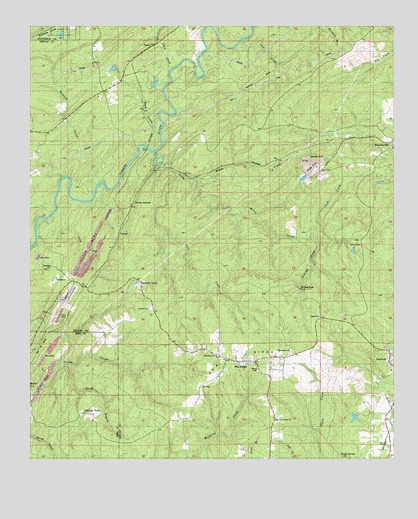
Pea Ridge, AL USGS Topographic Map
Click on map above to begin viewing in our Map Viewer.

This topographic map contains these locations and features:
Feature Name Type Latitude Longitude GNIS ID View Map
AdenPopulated PlaceN33.1587°W86.9967°155979View Map
AnitaPopulated PlaceN33.1743°W86.9803°155994View Map
Antioch Cemetery Number 2CemeteryN33.1690°W86.9589°146349View Map
Antioch ChurchChurchN33.1685°W86.9594°146350View Map
Barnes MineMineN33.2057°W86.9180°146355View Map
Bethel ChurchChurchN33.1537°W86.9328°1805563View Map
BoothtonPopulated PlaceN33.1798°W86.9905°154992View Map
Boothton CemeteryCemeteryN33.1807°W86.9925°146364View Map
Boothton MineMineN33.1723°W86.9694°146365View Map
Boothton StationLocaleN33.1704°W86.9847°114740View Map
Brantleyville Census Designated PlaceCensusN33.2196°W86.8820°2582663View Map
Dogwood ChurchChurchN33.1557°W86.8780°146412View Map
Dogwood MineMineN33.1585°W86.8833°146413View Map
Dogwood Number 3 MineMineN33.2265°W86.8833°146414View Map
Eddings TownPopulated PlaceN33.1385°W86.9792°138369View Map
Falling RockIslandN33.1723°W86.8997°118182View Map
Garnsey Number 2Populated PlaceN33.1571°W86.9889°118846View Map
Gentry SpringsSpringN33.1260°W86.8930°146440View Map
Gillispie MineMineN33.2140°W86.9180°146442View Map
Glade BranchStreamN33.1518°W86.9850°119015View Map
Glen CarbonPopulated PlaceN33.2043°W86.9583°119025View Map
Glen Carbon MineMineN33.1696°W86.9875°146443View Map
GurneePopulated PlaceN33.1896°W86.9686°119514View Map
Gurnee JunctionPopulated PlaceN33.1982°W86.9642°156441View Map
Gurnee MineMineN33.1821°W86.9694°146450View Map
Hancock CreekStreamN33.2048°W86.9764°119668View Map
Hurricane CreekStreamN33.2490°W86.9380°120591View Map
Jesse CreekStreamN33.2065°W86.9483°120881View Map
Lick CreekStreamN33.1948°W86.9908°121590View Map
Light of the Word ChurchChurchN33.1371°W86.9161°146495View Map
Lindseys CrossingPopulated PlaceN33.2304°W86.9272°156613View Map
Linholm CemeteryCemeteryN33.1554°W86.9353°146496View Map
Macedonia CemeteryCemeteryN33.1551°W86.9108°149448View Map
Macedonia ChurchChurchN33.1562°W86.9108°146501View Map
Marvel Baptist ChurchChurchN33.1462°W86.9994°151012View Map
Mayberry ChurchChurchN33.1548°W86.9367°146505View Map
Mayberry Elementary School (historical)SchoolN33.1537°W86.9333°149342View Map
Montevallo DivisionCivilN33.1393°W86.9033°165951View Map
Murry CreekStreamN33.2048°W86.9428°114259View Map
Pea RidgePopulated PlaceN33.1532°W86.9278°1989120View Map
Pea RidgeRidgeN33.1540°W86.9255°124521View Map
Pea Ridge ChurchChurchN33.1568°W86.9478°146636View Map
Pea Ridge Volunteer Fire and Rescue DepartmentBuildingN33.1541°W86.9336°2683420View Map
Peel CreekStreamN33.2448°W86.9258°124567View Map
Piney Woods CreekStreamN33.2134°W86.9561°124887View Map
Piney Woods TankLocaleN33.2171°W86.9517°124890View Map
Rajah MineMineN33.1446°W86.8930°146542View Map
Savage Creek MineMineN33.1521°W86.9908°138400View Map
Sawmill TownPopulated PlaceN33.1760°W86.9617°146559View Map
Shaw CreekStreamN33.2379°W86.9508°126651View Map
Sieard MineMineN33.2057°W86.9528°146575View Map
StravenPopulated PlaceN33.2196°W86.8897°153589View Map
Stravens MineMineN33.2112°W86.9017°146585View Map
SuperiorPopulated PlaceN33.2107°W86.9303°155265View Map
The Christian Mission ChurchChurchN33.1426°W86.9178°146590View Map
TulsePopulated PlaceN33.2451°W86.9028°128119View Map
TurnerPopulated PlaceN33.2448°W86.9555°128185View Map
Ward CreekStreamN33.2187°W86.9553°128573View Map
Whalley Mine (historical)MineN33.2112°W86.9167°146616View Map

Note: Coordinates in the location and feature list above are referenced to NAD83 datum.


Copyright (C) 2008-2024 Ryan Niemi / Sunset Dynamics ... All Rights Reserved