TopoQuest Logo
Do you find TopoQuest useful?
Help keep TopoQuest running and adding new maps/features by donating!
Bitcoin:  19c7KJd3qBynnjoSw5npx9KScwjBe4ifkT
Litecoin:  LXs6TkuXGGXo1vDsWCkWVdjQX94eUKd6ui
Home View Maps Find Maps Find Places Resources & Links


Greers Ferry, Arkansas Topographic Map

USGS Map Title: Greers Ferry, AR
USGS Map MRC: 35092E2
DRG (GeoTIFF) Download: o35092e2.tif


Neighboring USGS Topographic Map Quads:


  Shirley, AR  
35092F3
 

  Parma, AR  
35092F2
 

  Prim, AR  
35092F1
 

  Fairfield Bay, AR  
35092E3
 

  Greers Ferry, AR  
35092E2
 

  Brownsville, AR  
35092E1
 

  Morganton, AR  
35092D3
 

  Quitman, AR  
35092D2
 

  Heber Springs, AR  
35092D1


Map MRC Location:

N36°
W93°
N36°
W92°
H8 H7 H6 H5 H4 H3 H2 H1
G8 G7 G6 G5 G4 G3 G2 G1
F8 F7 F6 F5 F4 F3 F2 F1
E8 E7 E6 E5 E4 E3 E2 E1
D8 D7 D6 D5 D4 D3 D2 D1
C8 C7 C6 C5 C4 C3 C2 C1
B8 B7 B6 B5 B4 B3 B2 B1
A8 A7 A6 A5 A4 A3 A2 A1
N35°
W93°
N35°
W92°

Greers Ferry, AR USGS 1:24K Topographic Map Preview:
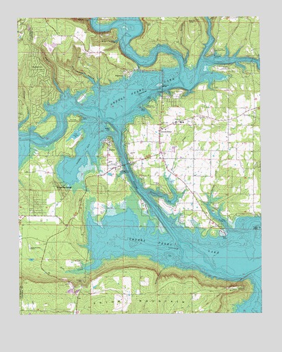
Greers Ferry, AR USGS Topographic Map
Click on map above to begin viewing in our Map Viewer.

This topographic map contains these locations and features:
Feature Name Type Latitude Longitude GNIS ID View Map
Bailey CemeteryCemeteryN35.5437°W92.2082°46011View Map
Bird HollowValleyN35.6159°W92.1982°46631View Map
Bondair AirportAirportN35.5468°W92.1857°83724View Map
Chalk (historical)Populated PlaceN35.5417°W92.2471°68650View Map
City of Greers FerryCivilN35.5674°W92.1687°2403759View Map
Cove Creek Volunteer Fire Department Station 2BuildingN35.5102°W92.1788°2116320View Map
Devils Fork Little Red RiverStreamN35.5987°W92.1668°48490View Map
Devils Fork Recreation AreaParkN35.5881°W92.1854°48491View Map
Diamond Bluff AirportAirportN35.5047°W92.1941°2650729View Map
Dunaway LakeReservoirN35.5116°W92.2112°79790View Map
Dunaway Lake DamDamN35.5117°W92.2118°79789View Map
EdgemontPopulated PlaceN35.6023°W92.1963°57700View Map
Edgemont BridgeBridgeN35.5962°W92.1757°48817View Map
Eva Turnley HollowValleyN35.5970°W92.2104°48928View Map
Fairfield Bay Volunteer Fire Department Station 3 Indian HillsBuildingN35.6083°W92.2439°2116616View Map
Goodin HollowValleyN35.6056°W92.1643°49498View Map
Greers FerryPopulated PlaceN35.5770°W92.1774°49672View Map
Greers Ferry AmbulanceBuildingN35.5777°W92.1742°2119134View Map
Greers Ferry Fire Department Station 1BuildingN35.5774°W92.1775°2116509View Map
Greers Ferry Fire Department Station 2BuildingN35.5856°W92.1269°2116510View Map
Greers Ferry Fire Department Station 3BuildingN35.5419°W92.2308°2116511View Map
Greers Ferry LakeReservoirN35.5325°W92.2044°75245View Map
Greers Ferry Nursery PondReservoirN35.5754°W92.2210°79620View Map
Greers Ferry Nursery Pond DamDamN35.5767°W92.2202°79619View Map
Greers Ferry Police DepartmentBuildingN35.5773°W92.1775°2118764View Map
HigdenPopulated PlaceN35.5734°W92.2032°50091View Map
Higden BayBayN35.5673°W92.2168°50092View Map
Higden ChurchChurchN35.5640°W92.2040°50093View Map
Higden-McLahaney ChapelChurchN35.5279°W92.2446°50094View Map
Hill CreekStreamN35.6076°W92.1557°50119View Map
Hill Creek MarinaLocaleN35.6090°W92.1485°50120View Map
Hill Creek Recreation AreaParkN35.6109°W92.1493°50121View Map
Holiday Hills United Methodist ChurchChurchN35.5798°W92.1765°77198View Map
Hurricane BayBayN35.5498°W92.1749°50425View Map
Hurricane CreekStreamN35.5498°W92.1852°50439View Map
Indian Hills Country ClubLocaleN35.6195°W92.2499°68673View Map
Jake HollowValleyN35.6237°W92.1507°50576View Map
Lone PinePopulated PlaceN35.5742°W92.1418°69502View Map
Lone Pine Baptist ChurchChurchN35.5754°W92.1415°77542View Map
Mill Creek Recreation AreaParkN35.5829°W92.2182°52034View Map
Millers PointCapeN35.5101°W92.1377°52071View Map
Narrows MarinaLocaleN35.5604°W92.1957°52574View Map
Narrows Recreation AreaParkN35.5640°W92.1982°52575View Map
Poker HillIslandN35.5784°W92.2021°53652View Map
Post OakPopulated PlaceN35.5723°W92.1771°69516View Map
Post Oak Baptist ChurchChurchN35.5723°W92.1779°78081View Map
Salt CreekStreamN35.5242°W92.2096°54517View Map
Shiloh (historical)Populated PlaceN35.5356°W92.1396°69522View Map
Shiloh ChurchChurchN35.5442°W92.1488°54797View Map
Shiloh CreekStreamN35.5342°W92.1357°78353View Map
Shiloh MarinaLocaleN35.5392°W92.1463°54802View Map
Shiloh Recreation AreaParkN35.5376°W92.1460°54804View Map
Skypoint Estates AirportAirportN35.6027°W92.1437°2650748View Map
Stewart HollowValleyN35.6237°W92.2124°55216View Map
Taylor IslandIslandN35.5359°W92.1268°55475View Map
Town of HigdenCivilN35.5666°W92.2048°2405826View Map
Township of GilesCivilN35.5660°W92.1456°66918View Map
Township of MorganCivilN35.6104°W92.2077°66923View Map
Township of SalineCivilN35.5492°W92.2123°66930View Map
Upper Ferry (historical)CrossingN35.5170°W92.1310°69534View Map
Verser's LandingAirportN35.5560°W92.1327°2650780View Map
Wagon BranchStreamN35.5931°W92.2271°55940View Map
West Side Baptist ChurchChurchN35.5829°W92.1565°78729View Map
West Side Elementary SchoolSchoolN35.5807°W92.1662°69536View Map
West Side High SchoolSchoolN35.5808°W92.1649°83527View Map
Whispering SpringsPopulated PlaceN35.5542°W92.2315°56239View Map
Wilburn KnobSummitN35.6234°W92.1596°58885View Map
Wildcat HollowValleyN35.5206°W92.1746°56363View Map

Note: Coordinates in the location and feature list above are referenced to NAD83 datum.


Copyright (C) 2008-2024 Ryan Niemi / Sunset Dynamics ... All Rights Reserved