TopoQuest Logo
Do you find TopoQuest useful?
Help keep TopoQuest running and adding new maps/features by donating!
Bitcoin:  19c7KJd3qBynnjoSw5npx9KScwjBe4ifkT
Litecoin:  LXs6TkuXGGXo1vDsWCkWVdjQX94eUKd6ui
Home View Maps Find Maps Find Places Resources & Links


Brownsville, Arkansas Topographic Map

USGS Map Title: Brownsville, AR
USGS Map MRC: 35092E1
DRG (GeoTIFF) Download: o35092e1.tif


Neighboring USGS Topographic Map Quads:


  Parma, AR  
35092F2
 

  Prim, AR  
35092F1
 

  Drasco, AR  
35091F8
 

  Greers Ferry, AR  
35092E2
 

  Brownsville, AR  
35092E1
 

  Greers Ferry Dam, AR  
35091E8
 

  Quitman, AR  
35092D2
 

  Heber Springs, AR  
35092D1
 

  West Pangburn, AR  
35091D8


Map MRC Location:

N36°
W93°
N36°
W92°
H8 H7 H6 H5 H4 H3 H2 H1
G8 G7 G6 G5 G4 G3 G2 G1
F8 F7 F6 F5 F4 F3 F2 F1
E8 E7 E6 E5 E4 E3 E2 E1
D8 D7 D6 D5 D4 D3 D2 D1
C8 C7 C6 C5 C4 C3 C2 C1
B8 B7 B6 B5 B4 B3 B2 B1
A8 A7 A6 A5 A4 A3 A2 A1
N35°
W93°
N35°
W92°

Brownsville, AR USGS 1:24K Topographic Map Preview:
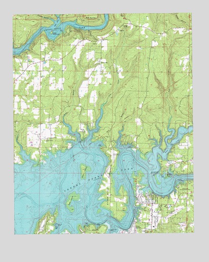
Brownsville, AR USGS Topographic Map
Click on map above to begin viewing in our Map Viewer.

This topographic map contains these locations and features:
Feature Name Type Latitude Longitude GNIS ID View Map
Aaron BranchStreamN35.5454°W92.0479°45769View Map
Bear MountainSummitN35.6231°W92.0677°57348View Map
BrownsvillePopulated PlaceN35.5981°W92.0654°76434View Map
Brownsville Baptist ChurchChurchN35.6101°W92.0629°76435View Map
Brownsville SpringSpringN35.6081°W92.0691°69467View Map
Budd CreekPopulated PlaceN35.5554°W92.1188°69468View Map
Budd CreekStreamN35.5417°W92.1146°47152View Map
Cases Ferry (historical)CrossingN35.5431°W92.0424°69469View Map
Cherokee Recreation AreaParkN35.5587°W92.0771°47721View Map
City of Heber SpringsCivilN35.5003°W92.0340°2404673View Map
Cleburne CountyCivilN35.5381°W92.0267°66983View Map
Copperas Spring HollowValleyN35.5492°W92.0246°48034View Map
Cove CreekStreamN35.5159°W92.1093°48104View Map
Dam Site MarinaLocaleN35.5295°W92.0076°48337View Map
Drip CreekStreamN35.5459°W92.0710°48605View Map
Dripping SpringSpringN35.6186°W92.0453°48606View Map
Eden IsleIslandN35.5059°W92.1035°76856View Map
Eden Isle MarinaLocaleN35.5059°W92.0957°76857View Map
Goat IslandIslandN35.5187°W92.0860°49460View Map
Greers Ferry (historical)CrossingN35.5309°W92.0129°69492View Map
Greers Ferry Fire Department Station 4BuildingN35.5867°W92.0762°2116512View Map
Heber Springs MarinaLocaleN35.5020°W92.0593°49983View Map
Heber Springs Municipal AirportAirportN35.5131°W92.0126°83720View Map
Heber Springs Post OfficePost OfficeN35.5047°W92.0286°2781855View Map
Heber Springs Recreation AreaParkN35.5040°W92.0665°49984View Map
Holland CemeteryCemeteryN35.6112°W92.0807°50196View Map
Hoover HollowValleyN35.6240°W92.0929°50293View Map
Lake RidgePopulated PlaceN35.5548°W92.0871°69499View Map
Little Goat IslandIslandN35.6145°W92.0979°51272View Map
Little Peter CreekStreamN35.5487°W92.0171°51307View Map
Lone Star Baptist ChurchChurchN35.5895°W92.1063°77547View Map
Lower Ferry (historical)CrossingN35.5254°W92.0927°69504View Map
Miller (historical)Populated PlaceN35.5070°W92.1238°69507View Map
Old Highway 25 Recreation AreasParkN35.5342°W92.0221°53000View Map
Peter CreekStreamN35.5345°W92.0310°53299View Map
Phalanx AirportAirportN35.5433°W92.0554°83719View Map
Pleasant Ridge Baptist ChurchChurchN35.5548°W92.0993°78056View Map
Pleasant Ridge CemeteryCemeteryN35.5534°W92.1032°53590View Map
Pleasant Ridge School (historical)SchoolN35.5629°W92.1057°69515View Map
Rocky BranchStreamN35.5476°W92.0765°54123View Map
Rodgers LakeReservoirN35.5517°W92.1135°80950View Map
Rodgers Lake DamDamN35.5517°W92.1135°80949View Map
Scout IslandIslandN35.5367°W92.0771°54650View Map
Silver Ridge PeninsulaCapeN35.5292°W92.0593°54851View Map
Sugar Camp CreekStreamN35.6154°W92.1013°55292View Map
TannenbaumPopulated PlaceN35.5590°W92.0571°69529View Map
Thunderbird Golf CourseLocaleN35.5267°W92.0385°82568View Map
Township of FrancisCivilN35.5758°W92.0568°66917View Map
Wildcat HollowValleyN35.6212°W92.0963°56367View Map
Wilsons Ford (historical)CrossingN35.6167°W92.0924°69540View Map

Note: Coordinates in the location and feature list above are referenced to NAD83 datum.


Copyright (C) 2008-2025 Ryan Niemi / Sunset Dynamics ... All Rights Reserved