TopoQuest Logo
Do you find TopoQuest useful?
Help keep TopoQuest running and adding new maps/features by donating!
Bitcoin:  19c7KJd3qBynnjoSw5npx9KScwjBe4ifkT
Litecoin:  LXs6TkuXGGXo1vDsWCkWVdjQX94eUKd6ui
Home View Maps Find Maps Find Places Resources & Links


Shirley, Arkansas Topographic Map

USGS Map Title: Shirley, AR
USGS Map MRC: 35092F3
DRG (GeoTIFF) Download: o35092f3.tif


Neighboring USGS Topographic Map Quads:


  Oxley, AR  
35092G4
 

  Fox, AR  
35092G3
 

  Mountain View SW, AR  
35092G2
 

  Old Lexington, AR  
35092F4
 

  Shirley, AR  
35092F3
 

  Parma, AR  
35092F2
 

  Clinton, AR  
35092E4
 

  Fairfield Bay, AR  
35092E3
 

  Greers Ferry, AR  
35092E2


Map MRC Location:

N36°
W93°
N36°
W92°
H8 H7 H6 H5 H4 H3 H2 H1
G8 G7 G6 G5 G4 G3 G2 G1
F8 F7 F6 F5 F4 F3 F2 F1
E8 E7 E6 E5 E4 E3 E2 E1
D8 D7 D6 D5 D4 D3 D2 D1
C8 C7 C6 C5 C4 C3 C2 C1
B8 B7 B6 B5 B4 B3 B2 B1
A8 A7 A6 A5 A4 A3 A2 A1
N35°
W93°
N35°
W92°

Shirley, AR USGS 1:24K Topographic Map Preview:
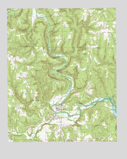
Shirley, AR USGS Topographic Map
Click on map above to begin viewing in our Map Viewer.

This topographic map contains these locations and features:
Feature Name Type Latitude Longitude GNIS ID View Map
Anderson HollowValleyN35.6551°W92.2557°45868View Map
Antioch ChurchChurchN35.7306°W92.2660°45899View Map
Arnold HollowValleyN35.7470°W92.3663°45936View Map
Bat Cave HollowValleyN35.6829°W92.3007°46143View Map
Bear BranchStreamN35.6926°W92.3227°46199View Map
Bud Brown HillSummitN35.6629°W92.3449°57462View Map
Buffalo HumpCliffN35.6429°W92.2957°47158View Map
Chimney RocksPillarN35.6915°W92.3396°47747View Map
Collins CemeteryCemeteryN35.6573°W92.2910°47932View Map
Deer Drive HollowValleyN35.7295°W92.3502°48456View Map
Dodd MountainSummitN35.6648°W92.3688°57665View Map
Fairfield BayBayN35.6267°W92.2740°48957View Map
Files HollowValleyN35.7492°W92.3065°49045View Map
Fox Fire Department Station 1BuildingN35.7476°W92.2831°2116457View Map
Full Gospel TabernacleChurchN35.6634°W92.3432°49287View Map
Gannon RidgeRidgeN35.6795°W92.3338°49322View Map
Good Spur HollowValleyN35.6590°W92.3243°49494View Map
Greenbrier CreekStreamN35.6654°W92.2615°49650View Map
Harper BluffsCliffN35.7395°W92.3246°49878View Map
Harris HollowValleyN35.7379°W92.3738°49903View Map
Hump HollowValleyN35.6440°W92.2971°50406View Map
Indian CreekStreamN35.6692°W92.2502°50499View Map
John Henry MountainSummitN35.6820°W92.3196°57993View Map
Johnson HollowValleyN35.6962°W92.2515°50701View Map
KFFB-FM (Fairfield Bay)TowerN35.6829°W92.2799°85387View Map
KFFB-FM (Fairfield Bay)TowerN35.7334°W92.2604°85388View Map
Kinder SloughStreamN35.7034°W92.3065°50846View Map
Little CreekStreamN35.6345°W92.3729°51245View Map
Lost CreekStreamN35.7412°W92.3396°51462View Map
Lute CemeteryCemeteryN35.6990°W92.3429°51517View Map
Lute MountainSummitN35.7192°W92.3354°58105View Map
LydaliskPopulated PlaceN35.7440°W92.3343°77565View Map
McCann HollowValleyN35.7009°W92.2657°51784View Map
Moccasin HollowValleyN35.6731°W92.3024°52124View Map
Moon BluffsCliffN35.7470°W92.3593°52147View Map
Mule HollowValleyN35.7334°W92.3254°52542View Map
Nubbin RidgeRidgeN35.7406°W92.3129°52858View Map
Payne MountainSummitN35.7076°W92.2824°58337View Map
Pekin (historical)Populated PlaceN35.7381°W92.3627°65841View Map
Poe (historical)Populated PlaceN35.6623°W92.2682°68689View Map
Porter HollowValleyN35.7326°W92.2946°53703View Map
Pour Off HollowValleyN35.7101°W92.2971°53733View Map
RushingPopulated PlaceN35.7354°W92.2646°58560View Map
Rushing CemeteryCemeteryN35.7298°W92.2674°54283View Map
Sally FlatsFlatN35.7348°W92.3657°54510View Map
Settlement (historical)Populated PlaceN35.6445°W92.3149°68697View Map
Settlement CemeteryCemeteryN35.6437°W92.3138°54675View Map
Ship BranchStreamN35.6656°W92.2629°54807View Map
ShirleyPopulated PlaceN35.6562°W92.3193°54811View Map
Shirley Elementary SchoolSchoolN35.6607°W92.3112°68699View Map
Shirley Fire Department Station 1BuildingN35.6549°W92.3190°2117122View Map
Shirley Fire Department Station 2BuildingN35.6825°W92.3530°2117123View Map
Shirley High SchoolSchoolN35.6593°W92.3130°68700View Map
Shirley Post OfficePost OfficeN35.6579°W92.3197°2781886View Map
Simkins PointSummitN35.6906°W92.3143°54853View Map
Still HollowValleyN35.7076°W92.2977°55221View Map
Tick CreekStreamN35.6987°W92.3085°45766View Map
Town of ShirleyCivilN35.6445°W92.3137°2407328View Map
Township of UnionCivilN35.6603°W92.3091°69776View Map
Weaver CreekStreamN35.6501°W92.2924°78710View Map

Note: Coordinates in the location and feature list above are referenced to NAD83 datum.


Copyright (C) 2008-2025 Ryan Niemi / Sunset Dynamics ... All Rights Reserved