TopoQuest Logo
Do you find TopoQuest useful?
Help keep TopoQuest running and adding new maps/features by donating!
Bitcoin:  19c7KJd3qBynnjoSw5npx9KScwjBe4ifkT
Litecoin:  LXs6TkuXGGXo1vDsWCkWVdjQX94eUKd6ui
Home View Maps Find Maps Find Places Resources & Links


Greers Ferry Dam, Arkansas Topographic Map

USGS Map Title: Greers Ferry Dam, AR
USGS Map MRC: 35091E8
DRG (GeoTIFF) Download: o35091e8.tif


Neighboring USGS Topographic Map Quads:


  Prim, AR  
35092F1
 

  Drasco, AR  
35091F8
 

  Concord, AR  
35091F7
 

  Brownsville, AR  
35092E1
 

  Greers Ferry Dam, AR  
35091E8
 

  Floral, AR  
35091E7
 

  Heber Springs, AR  
35092D1
 

  West Pangburn, AR  
35091D8
 

  Pangburn, AR  
35091D7


Map MRC Location:

N36°
W92°
N36°
W91°
H8 H7 H6 H5 H4 H3 H2 H1
G8 G7 G6 G5 G4 G3 G2 G1
F8 F7 F6 F5 F4 F3 F2 F1
E8 E7 E6 E5 E4 E3 E2 E1
D8 D7 D6 D5 D4 D3 D2 D1
C8 C7 C6 C5 C4 C3 C2 C1
B8 B7 B6 B5 B4 B3 B2 B1
A8 A7 A6 A5 A4 A3 A2 A1
N35°
W92°
N35°
W91°

Greers Ferry Dam, AR USGS 1:24K Topographic Map Preview:
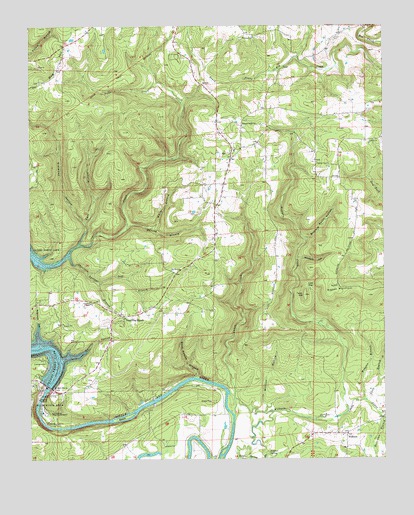
Greers Ferry Dam, AR USGS Topographic Map
Click on map above to begin viewing in our Map Viewer.

This topographic map contains these locations and features:
Feature Name Type Latitude Longitude GNIS ID View Map
Abrams BranchStreamN35.5223°W91.8774°45774View Map
Antioch Baptist ChurchChurchN35.6215°W91.9235°76178View Map
Antioch CemeteryCemeteryN35.6212°W91.9251°69465View Map
Baptist Health Medical Center Heber SpringsHospitalN35.5044°W91.9981°69475View Map
Beech IslandIslandN35.5126°W91.9663°46333View Map
Betty Brown LakeReservoirN35.5001°W91.9618°79784View Map
Betty Brown Lake DamDamN35.5001°W91.9618°79783View Map
Buzzard Roost HollowValleyN35.5631°W91.9029°47250View Map
Canoe CreekStreamN35.5129°W91.9276°47450View Map
Carr HollowValleyN35.5623°W91.9826°47479View Map
Cedar BranchStreamN35.5170°W91.8821°47576View Map
Chastain Chapel Baptist ChurchChurchN35.5451°W91.9788°76593View Map
Chastain Springs BranchStreamN35.5587°W91.9863°47713View Map
Cleburne County LandfillLocaleN35.5114°W91.9128°2726683View Map
Dam Site Recreation AreaParkN35.5220°W91.9976°48339View Map
Dill BranchStreamN35.5512°W91.9751°48516View Map
Greers Ferry DamDamN35.5209°W91.9932°74865View Map
Greers Ferry National Fish HatcheryParkN35.5135°W91.9949°2765323View Map
Holliman BranchStreamN35.5131°W91.8771°50201View Map
IdaPopulated PlaceN35.5881°W91.9279°50480View Map
Ida Post OfficePost OfficeN35.5801°W91.9307°84496View Map
Liberty CreekStreamN35.5129°W91.8901°51112View Map
Low GapGapN35.5501°W91.9021°51489View Map
Miller CemeteryCemeteryN35.5851°W91.8938°52058View Map
Murray BranchStreamN35.5665°W91.9654°52558View Map
Pleasant Ridge Baptist ChurchChurchN35.5962°W91.9240°78057View Map
R-T45/p124SchoolN35.5434°W91.9571°69531View Map
Rigdon MountainSummitN35.5492°W91.8932°58491View Map
Ritchie ShoalsBarN35.5120°W91.9288°69520View Map
Robinson HollowValleyN35.5331°W91.9957°54078View Map
Rock House HollowValleyN35.5242°W91.9410°54103View Map
Simmons HollowValleyN35.5687°W91.9807°54859View Map
Slate BranchStreamN35.5173°W91.8818°54896View Map
Sulphur SpringSpringN35.5017°W91.9154°55323View Map
Tater HillSummitN35.5473°W91.9024°55445View Map
Township of East Peter CreekCivilN35.5955°W91.9427°2406948View Map
Township of Peter CreekCivilN35.5802°W91.9370°66925View Map
Township of West Peter CreekCivilN35.5481°W91.9624°2407401View Map
Tumbling ShoalsPopulated PlaceN35.5420°W91.9674°55697View Map
Tumbling Shoals Census Designated PlaceCensusN35.5479°W91.9689°2612133View Map
Tumbling Shoals Ida Volunteer Fire DepartmentBuildingN35.5427°W91.9592°2117228View Map
Tumbling Shoals Methodist ChurchChurchN35.5409°W91.9668°69530View Map
Tumbling Shoals Post OfficePost OfficeN35.5419°W91.9637°84497View Map
Tumbling Shoals Volunteer Emergency Medical ServicesBuildingN35.5942°W91.9256°2119133View Map
Tumbling Shoals Volunteer Fire DepartmentBuildingN35.5942°W91.9256°2117229View Map
United States Fish and Wildlife Greers Ferry National Fish Hatchery Park SecurityBuildingN35.5138°W91.9957°2118769View Map
Wackley HollowValleyN35.5292°W91.9879°55931View Map
Webster BranchStreamN35.5170°W91.8826°56136View Map
White BranchStreamN35.5670°W91.9563°56244View Map
WilburnPopulated PlaceN35.5073°W91.8882°56348View Map
Wilburn CreekStreamN35.5176°W91.9279°56349View Map
Wilburn Elementary SchoolSchoolN35.5032°W91.8886°69537View Map
Wilburn High SchoolSchoolN35.5032°W91.8894°69538View Map
Wilburn RescueBuildingN35.5078°W91.8904°2119136View Map
Wilburn Volunteer Fire DepartmentBuildingN35.5078°W91.8905°2117318View Map
Wildcat HollowValleyN35.5154°W91.9174°56362View Map
Woodam HollowValleyN35.5581°W91.9051°56516View Map

Note: Coordinates in the location and feature list above are referenced to NAD83 datum.


Copyright (C) 2008-2024 Ryan Niemi / Sunset Dynamics ... All Rights Reserved