TopoQuest Logo
Do you find TopoQuest useful?
Help keep TopoQuest running and adding new maps/features by donating!
Bitcoin:  19c7KJd3qBynnjoSw5npx9KScwjBe4ifkT
Litecoin:  LXs6TkuXGGXo1vDsWCkWVdjQX94eUKd6ui
Home View Maps Find Maps Find Places Resources & Links


Pangburn, Arkansas Topographic Map

USGS Map Title: Pangburn, AR
USGS Map MRC: 35091D7
DRG (GeoTIFF) Download: o35091d7.tif


Neighboring USGS Topographic Map Quads:


  Greers Ferry Dam, AR  
35091E8
 

  Floral, AR  
35091E7
 

  Pleasant Plains, AR  
35091E6
 

  West Pangburn, AR  
35091D8
 

  Pangburn, AR  
35091D7
 

  Steprock, AR  
35091D6
 

  Sidon, AR  
35091C8
 

  Letona, AR  
35091C7
 

  Judsonia, AR  
35091C6


Map MRC Location:

N36°
W92°
N36°
W91°
H8 H7 H6 H5 H4 H3 H2 H1
G8 G7 G6 G5 G4 G3 G2 G1
F8 F7 F6 F5 F4 F3 F2 F1
E8 E7 E6 E5 E4 E3 E2 E1
D8 D7 D6 D5 D4 D3 D2 D1
C8 C7 C6 C5 C4 C3 C2 C1
B8 B7 B6 B5 B4 B3 B2 B1
A8 A7 A6 A5 A4 A3 A2 A1
N35°
W92°
N35°
W91°

Pangburn, AR USGS 1:24K Topographic Map Preview:
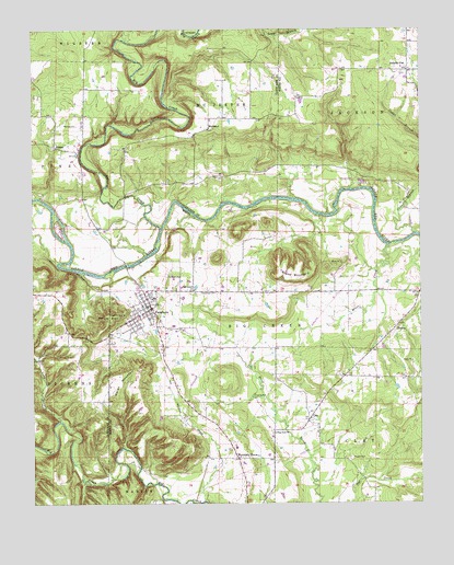
Pangburn, AR USGS Topographic Map
Click on map above to begin viewing in our Map Viewer.

This topographic map contains these locations and features:
Feature Name Type Latitude Longitude GNIS ID View Map
Barnett CemeteryCemeteryN35.4751°W91.8610°46111View Map
Big CreekStreamN35.4476°W91.8340°46534View Map
Brier CreekStreamN35.4431°W91.7601°46949View Map
Bruce MountainSummitN35.4342°W91.7888°47032View Map
Cedar BranchStreamN35.4587°W91.7501°47574View Map
City of PangburnCivilN35.4261°W91.8387°2404470View Map
ClayPopulated PlaceN35.3967°W91.7863°47811View Map
DeweyPopulated PlaceN35.4212°W91.7582°57651View Map
Dripping Springs LandingLocaleN35.4356°W91.8585°69483View Map
Faulkner CemeteryCemeteryN35.4351°W91.8318°49012View Map
Full Gospel ChurchChurchN35.4312°W91.8232°49285View Map
Henderson CemeteryCemeteryN35.4306°W91.8226°50007View Map
Hickory FlatPopulated PlaceN35.4892°W91.7538°50053View Map
Hickory Flat Volunteer Fire DepartmentBuildingN35.4910°W91.7542°2116560View Map
HiramPopulated PlaceN35.4692°W91.8679°50151View Map
Howell CemeteryCemeteryN35.3870°W91.7726°50367View Map
Long BranchStreamN35.3967°W91.8668°77549View Map
Marsh MountainSummitN35.4029°W91.8493°58129View Map
McJesterPopulated PlaceN35.4740°W91.8185°58151View Map
Mount ZionSummitN35.4245°W91.8504°58229View Map
Mountain HomePopulated PlaceN35.3867°W91.8090°77765View Map
PangburnPopulated PlaceN35.4267°W91.8368°53143View Map
Pangburn Elementary SchoolSchoolN35.4292°W91.8352°65101View Map
Pangburn High SchoolSchoolN35.4293°W91.8359°65102View Map
Pangburn Police DepartmentBuildingN35.4269°W91.8373°2118626View Map
Pangburn Post OfficePost OfficeN35.4247°W91.8398°84968View Map
Pangburn Volunteer Fire StationBuildingN35.4270°W91.8374°2116927View Map
Pine View ChurchChurchN35.3934°W91.7971°53472View Map
Rainbow IslandPopulated PlaceN35.4479°W91.8668°75296View Map
Ramsey LandingLocaleN35.4523°W91.7763°65105View Map
Township of Big CreekCivilN35.4186°W91.8013°69816View Map
Township of ClayCivilN35.3769°W91.7512°69820View Map
Township of McJesterCivilN35.4872°W91.8130°66922View Map
Township of PineCivilN35.4760°W91.8727°66927View Map

Note: Coordinates in the location and feature list above are referenced to NAD83 datum.


Copyright (C) 2008-2025 Ryan Niemi / Sunset Dynamics ... All Rights Reserved