TopoQuest Logo
Do you find TopoQuest useful?
Help keep TopoQuest running and adding new maps/features by donating!
Bitcoin:  19c7KJd3qBynnjoSw5npx9KScwjBe4ifkT
Litecoin:  LXs6TkuXGGXo1vDsWCkWVdjQX94eUKd6ui
Home View Maps Find Maps Find Places Resources & Links


Grimesland, North Carolina Topographic Map

USGS Map Title: Grimesland, NC
USGS Map MRC: 35077E2
DRG (GeoTIFF) Download: o35077e2.tif


Neighboring USGS Topographic Map Quads:


  Greenville NE, NC  
35077F3
 

  Leggetts Crossroads, NC  
35077F2
 

  Old Ford, NC  
35077F1
 

  Greenville SE, NC  
35077E3
 

  Grimesland, NC  
35077E2
 

  Washington, NC  
35077E1
 

  Gardnerville, NC  
35077D3
 

  Wilmar, NC  
35077D2
 

  Hackney, NC  
35077D1


Map MRC Location:

N36°
W78°
N36°
W77°
H8 H7 H6 H5 H4 H3 H2 H1
G8 G7 G6 G5 G4 G3 G2 G1
F8 F7 F6 F5 F4 F3 F2 F1
E8 E7 E6 E5 E4 E3 E2 E1
D8 D7 D6 D5 D4 D3 D2 D1
C8 C7 C6 C5 C4 C3 C2 C1
B8 B7 B6 B5 B4 B3 B2 B1
A8 A7 A6 A5 A4 A3 A2 A1
N35°
W78°
N35°
W77°

Grimesland, NC USGS 1:24K Topographic Map Preview:
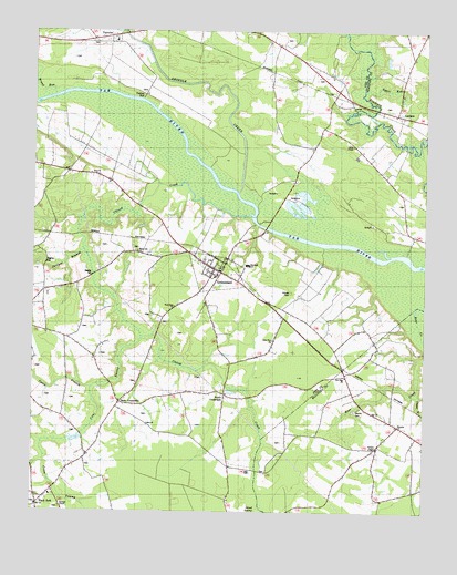
Grimesland, NC USGS Topographic Map
Click on map above to begin viewing in our Map Viewer.

This topographic map contains these locations and features:
Feature Name Type Latitude Longitude GNIS ID View Map
Aggie RunStreamN35.6102°W77.1447°980062View Map
Avon Landing (historical)LocaleN35.5904°W77.2186°1008194View Map
Bible Way ChurchChurchN35.5449°W77.1730°981293View Map
Black JackPopulated PlaceN35.5018°W77.2477°1008235View Map
Black Jack Volunteer Fire DepartmentBuildingN35.5002°W77.2478°2639549View Map
Blakleys Fishery (historical)LocaleN35.5746°W77.1783°1008193View Map
Boyd CrossroadsPopulated PlaceN35.5307°W77.1886°1006137View Map
Boyd Ferry (historical)LocaleN35.5754°W77.1783°1023598View Map
Boyd FieldAirportN35.5309°W77.1992°2679189View Map
Broad RunStreamN35.6088°W77.2427°981948View Map
BryanLocaleN35.5541°W77.1744°1007388View Map
Burneys ChapelChurchN35.5013°W77.2405°982286View Map
Cabin BranchStreamN35.5324°W77.2308°1023868View Map
Chapel BranchStreamN35.5307°W77.1280°983004View Map
Chicod CreekStreamN35.5777°W77.1805°1019660View Map
Clarks Landing (historical)LocaleN35.5674°W77.1308°1008203View Map
Clarks Neck Volunteer Fire Department Station 1BuildingN35.5885°W77.1393°2638213View Map
Cow SwampStreamN35.5457°W77.2152°1023927View Map
Cross SwampStreamN35.5135°W77.2458°983792View Map
First Born ChurchChurchN35.5535°W77.2047°985085View Map
G R Whitefield SchoolSchoolN35.5643°W77.1816°1024406View Map
Grimes CemeteryCemeteryN35.5574°W77.1677°986160View Map
Grimes Landing (historical)LocaleN35.5691°W77.1572°1023599View Map
Grimes MillpondLakeN35.5293°W77.1786°1008186View Map
GrimeslandPopulated PlaceN35.5635°W77.1922°1020564View Map
Grimesland Fire DepartmentBuildingN35.5621°W77.1916°1007453View Map
Grimesland Pentecostal ChurchChurchN35.5683°W77.2003°2506145View Map
Grimesland Post OfficePost OfficeN35.5631°W77.1906°2774101View Map
Grindle CreekStreamN35.5832°W77.1847°1024012View Map
Hams CrossroadsPopulated PlaceN35.5285°W77.2216°1006228View Map
Hodges ChapelChurchN35.5168°W77.1394°986870View Map
Holy Ghost Deliverance ChurchChurchN35.5647°W77.1917°2506158View Map
Island SwampStreamN35.5024°W77.1769°1024564View Map
Jones ChapelChurchN35.5957°W77.1483°987736View Map
Juniper BranchStreamN35.5679°W77.2338°1024070View Map
LathamPopulated PlaceN35.6035°W77.1341°1006271View Map
One Way ChurchChurchN35.5354°W77.1497°991660View Map
Pactolus Elementary SchoolSchoolN35.6226°W77.2217°1007454View Map
Pactolus Emergency Medical ServicesBuildingN35.6227°W77.2293°2720523View Map
Pactolus Volunteer Fire DepartmentBuildingN35.6226°W77.2298°2639142View Map
Panther CreekStreamN35.5668°W77.1355°1008215View Map
Piney Grove ChurchChurchN35.5160°W77.1408°1008160View Map
Town of GrimeslandCivilN35.5623°W77.1915°2406622View Map
Township of GrimeslandCivilN35.5564°W77.2204°1027064View Map
Triumph ChurchChurchN35.6060°W77.1486°996264View Map
Wayside ChurchChurchN35.5227°W77.1333°996896View Map
Wesley CemeteryCemeteryN35.5265°W77.1469°996960View Map
White Oak ChurchChurchN35.5677°W77.2166°997163View Map
Yankee HallLocaleN35.6085°W77.2150°1000800View Map

Note: Coordinates in the location and feature list above are referenced to NAD83 datum.


Copyright (C) 2008-2024 Ryan Niemi / Sunset Dynamics ... All Rights Reserved