TopoQuest Logo
Do you find TopoQuest useful?
Help keep TopoQuest running and adding new maps/features by donating!
Bitcoin:  19c7KJd3qBynnjoSw5npx9KScwjBe4ifkT
Litecoin:  LXs6TkuXGGXo1vDsWCkWVdjQX94eUKd6ui
Home View Maps Find Maps Find Places Resources & Links


Grundy, Virginia Topographic Map

USGS Map Title: Grundy, VA
USGS Map MRC: 37082C1
DRG (GeoTIFF) Download: o37082c1.tif


Neighboring USGS Topographic Map Quads:


  Jamboree, KY  
37082D2
 

  Hurley, VA  
37082D1
 

  Panther, WV  
37081D8
 

  Harman, VA  
37082C2
 

  Grundy, VA  
37082C1
 

  Patterson, VA  
37081C8
 

  Prater, VA  
37082B2
 

  Vansant, VA  
37082B1
 

  Keen Mountain, VA  
37081B8


Map MRC Location:

N38°
W83°
N38°
W82°
H8 H7 H6 H5 H4 H3 H2 H1
G8 G7 G6 G5 G4 G3 G2 G1
F8 F7 F6 F5 F4 F3 F2 F1
E8 E7 E6 E5 E4 E3 E2 E1
D8 D7 D6 D5 D4 D3 D2 D1
C8 C7 C6 C5 C4 C3 C2 C1
B8 B7 B6 B5 B4 B3 B2 B1
A8 A7 A6 A5 A4 A3 A2 A1
N37°
W83°
N37°
W82°

Grundy, VA USGS 1:24K Topographic Map Preview:
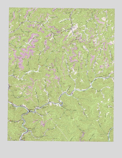
Grundy, VA USGS Topographic Map
Click on map above to begin viewing in our Map Viewer.

This topographic map contains these locations and features:
Feature Name Type Latitude Longitude GNIS ID View Map
Anderson BranchStreamN37.3548°W82.1132°1462456View Map
Bear HollowValleyN37.3705°W82.0514°1462895View Map
Belcher CemeteryCemeteryN37.3157°W82.0890°1463016View Map
Booth BranchStreamN37.2840°W82.0607°1463671View Map
Brushy ForkStreamN37.3654°W82.0268°1463950View Map
Brushy SchoolSchoolN37.3657°W82.0265°1463955View Map
Buchanan ChurchChurchN37.2643°W82.1068°1463969View Map
Buchanan CountyCivilN37.2666°W82.0360°1497431View Map
Buchanan County CourthouseBuildingN37.2776°W82.0990°1497432View Map
Buchanan County Sheriff's OfficeBuildingN37.2776°W82.0992°2767080View Map
Buchanan County Technology and Career CenterSchoolN37.2780°W82.0966°2498455View Map
Buchanan General HospitalHospitalN37.2853°W82.0655°1497433View Map
Dave BranchStreamN37.2804°W82.0887°1465624View Map
Elkins BranchStreamN37.2979°W82.0454°1466235View Map
Elkins School (historical)SchoolN37.3023°W82.0454°1497444View Map
Elswick ForkStreamN37.3626°W82.1043°1466267View Map
Enochs BranchStreamN37.2962°W82.0585°1466309View Map
F B Fowler HeliportAirportN37.2809°W82.1021°1480228View Map
Feds Camp BranchStreamN37.3212°W82.0818°1466516View Map
Fletcher CemeteryCemeteryN37.3590°W82.0865°1466704View Map
Fletcher CemeteryCemeteryN37.3287°W82.1101°1497445View Map
Grape BranchStreamN37.2562°W82.0054°1467354View Map
GrundyPopulated PlaceN37.2779°W82.0990°1498485View Map
Grundy High SchoolSchoolN37.2833°W82.0613°1467579View Map
Grundy Post OfficePost OfficeN37.2780°W82.0983°2766370View Map
Grundy Volunteer Fire DepartmentBuildingN37.2837°W82.1183°2721032View Map
Hobbs BranchStreamN37.2934°W82.0512°1468081View Map
Home CreekPopulated PlaceN37.3504°W82.0707°1495709View Map
Home Creek School (historical)SchoolN37.3618°W82.0890°1497452View Map
Horse BranchStreamN37.3068°W82.0462°1468257View Map
J M Bevins Elementary SchoolSchoolN37.2692°W82.1049°2498473View Map
Left Fork Looney CreekStreamN37.3118°W82.1201°1469295View Map
Left Fork School (historical)SchoolN37.3590°W82.0343°1497466View Map
Lick BranchStreamN37.3012°W82.0279°1469390View Map
Licklog BranchStreamN37.3598°W82.0849°1469420View Map
Linn Camp School (historical)SchoolN37.3379°W82.1157°1497468View Map
Little Prater CreekStreamN37.2512°W82.1087°1469623View Map
LongbottomPopulated PlaceN37.2818°W82.0854°1495869View Map
Looney CemeteryCemeteryN37.2970°W82.0535°1469858View Map
Looney Creek SchoolSchoolN37.3112°W82.1187°1469863View Map
Lower Mill BranchStreamN37.2865°W82.0757°1469916View Map
McClanahan CemeteryCemeteryN37.3120°W82.0065°1470228View Map
Mountain Mission SchoolSchoolN37.2819°W82.0889°1471173View Map
Mule HollowValleyN37.3503°W82.0720°1471252View Map
New Wolfpen BranchStreamN37.3159°W82.0993°1471505View Map
Newhouse BranchStreamN37.2773°W82.0932°1471517View Map
North Grundy DistrictCivilN37.3157°W82.0130°1927426View Map
Old Wolfpen BranchStreamN37.3193°W82.0874°1471885View Map
Peeled Poplar ForkStreamN37.3648°W82.0518°1472175View Map
PoetownPopulated PlaceN37.2829°W82.1085°1496099View Map
Raitt TunnelTunnelN37.3529°W82.0654°1472949View Map
RoseannPopulated PlaceN37.3559°W82.0510°1496167View Map
Roseann SchoolSchoolN37.3532°W82.0562°1473542View Map
Rowe MountainSummitN37.2721°W82.0096°1496177View Map
Rowe Mountain School (historical)SchoolN37.2834°W82.0124°1497480View Map
Royal CityPopulated PlaceN37.2598°W82.1007°1473609View Map
Shortridge CemeteryCemeteryN37.3140°W82.1037°1474560View Map
Shortridge CemeteryCemeteryN37.3620°W82.0865°1474561View Map
Slate CreekStreamN37.2787°W82.1004°1474669View Map
Spencer ForkStreamN37.3596°W82.1110°1474940View Map
Stillhouse HollowValleyN37.2959°W82.0568°1475148View Map
Stonecoal BranchStreamN37.3101°W82.0210°1475188View Map
Stonecoal School (historical)SchoolN37.3104°W82.0137°1475190View Map
Three and Twentymile BranchStreamN37.2709°W82.1074°1474288View Map
TooklandPopulated PlaceN37.2504°W82.1085°1496319View Map
Town of GrundyCivilN37.2754°W82.0988°2390222View Map
Upper Mill BranchStreamN37.3048°W82.0268°1476118View Map
Watkins BranchStreamN37.2596°W82.1015°1476380View Map
White Oak BranchStreamN37.3112°W82.0060°1476597View Map
WMJD-FM (Grundy)TowerN37.3023°W82.1176°1498989View Map
WNRG-AM (Grundy)TowerN37.3023°W82.1176°1498939View Map

Note: Coordinates in the location and feature list above are referenced to NAD83 datum.


Copyright (C) 2008-2024 Ryan Niemi / Sunset Dynamics ... All Rights Reserved