TopoQuest Logo
Do you find TopoQuest useful?
Help keep TopoQuest running and adding new maps/features by donating!
Bitcoin:  19c7KJd3qBynnjoSw5npx9KScwjBe4ifkT
Litecoin:  LXs6TkuXGGXo1vDsWCkWVdjQX94eUKd6ui
Home View Maps Find Maps Find Places Resources & Links


Vansant, Virginia Topographic Map

USGS Map Title: Vansant, VA
USGS Map MRC: 37082B1
DRG (GeoTIFF) Download: o37082b1.tif


Neighboring USGS Topographic Map Quads:


  Harman, VA  
37082C2
 

  Grundy, VA  
37082C1
 

  Patterson, VA  
37081C8
 

  Prater, VA  
37082B2
 

  Vansant, VA  
37082B1
 

  Keen Mountain, VA  
37081B8
 

  Duty, VA  
37082A2
 

  Big A Mountain, VA  
37082A1
 

  Honaker, VA  
37081A8


Map MRC Location:

N38°
W83°
N38°
W82°
H8 H7 H6 H5 H4 H3 H2 H1
G8 G7 G6 G5 G4 G3 G2 G1
F8 F7 F6 F5 F4 F3 F2 F1
E8 E7 E6 E5 E4 E3 E2 E1
D8 D7 D6 D5 D4 D3 D2 D1
C8 C7 C6 C5 C4 C3 C2 C1
B8 B7 B6 B5 B4 B3 B2 B1
A8 A7 A6 A5 A4 A3 A2 A1
N37°
W83°
N37°
W82°

Vansant, VA USGS 1:24K Topographic Map Preview:
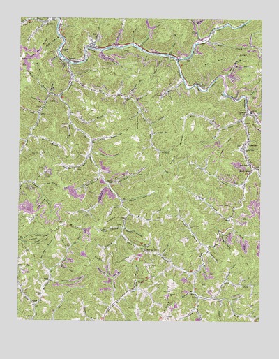
Vansant, VA USGS Topographic Map
Click on map above to begin viewing in our Map Viewer.

This topographic map contains these locations and features:
Feature Name Type Latitude Longitude GNIS ID View Map
Arminta Post Office (historical)Post OfficeN37.1586°W82.0243°2336239View Map
Arwood HollowValleyN37.1342°W82.0195°1462572View Map
Baldwin BranchStreamN37.1807°W82.0782°1462714View Map
Baldwin BranchStreamN37.1951°W82.0521°1462715View Map
Baldwin CemeteryCemeteryN37.1718°W82.0868°1462717View Map
Baldwin MountainSummitN37.2001°W82.0396°1499085View Map
Bens BranchStreamN37.2354°W82.0868°1463078View Map
Berry HollowValleyN37.1337°W82.0146°1463107View Map
Big Cedar BranchStreamN37.2023°W82.0554°1463335View Map
Big ForkStreamN37.2068°W82.0974°1463351View Map
Big HollowValleyN37.1814°W82.1240°1463361View Map
Big Lick BranchStreamN37.2190°W82.1090°1463374View Map
Big Prater CreekStreamN37.2318°W82.0990°1463392View Map
Big Rock BranchStreamN37.2184°W82.1035°1463396View Map
Box BranchStreamN37.1379°W82.0099°1463721View Map
Box Camp CreekStreamN37.1693°W82.0674°1463722View Map
Boyd BranchStreamN37.1315°W82.1160°1463724View Map
Boyd CemeteryCemeteryN37.1470°W82.1226°1463726View Map
Boyd CemeteryCemeteryN37.1554°W82.0987°1463727View Map
Boyd CemeteryCemeteryN37.1682°W82.1162°1463728View Map
Boyd ForkStreamN37.1537°W82.0987°1463730View Map
Boyd RidgeRidgeN37.1632°W82.0874°1463732View Map
Boyd SchoolSchoolN37.1265°W82.1162°1463734View Map
Breeden BranchStreamN37.1557°W82.0268°1463778View Map
Breeding CemeteryCemeteryN37.1357°W82.1124°1463784View Map
Breeding ChapelChurchN37.1321°W82.1151°1463785View Map
Childress CreekStreamN37.2365°W82.0629°1464846View Map
Clear Fork BranchStreamN37.2254°W82.0974°1464969View Map
Coleman BranchStreamN37.1540°W82.0265°1465080View Map
Coleman CemeteryCemeteryN37.1643°W82.0360°1465081View Map
Cook CemeteryCemeteryN37.1623°W82.0899°1465188View Map
Cook ForkStreamN37.1537°W82.0987°1465189View Map
Copper Mine BranchStreamN37.2262°W82.0190°1465233View Map
Cox BranchStreamN37.2068°W82.0565°1465355View Map
Cripple CreekStreamN37.2462°W82.1126°1465437View Map
Crooked BranchStreamN37.1693°W82.0679°1465456View Map
Dark HollowValleyN37.2354°W82.0586°1465611View Map
DeelPopulated PlaceN37.2362°W82.0882°1499332View Map
DeskinsPopulated PlaceN37.1815°W82.0774°1477260View Map
Deskins ChurchChurchN37.1668°W82.0690°1465736View Map
Devil BranchStreamN37.2109°W82.0985°1465739View Map
Dismal CreekStreamN37.2334°W82.0426°1465819View Map
Dry ForkStreamN37.2254°W82.0976°1465993View Map
Fletcher BranchStreamN37.1379°W82.0337°1466695View Map
Fletcher ChurchChurchN37.1357°W82.0457°1466705View Map
Fletcher RidgeRidgeN37.1587°W82.1137°1466707View Map
Garden CreekStreamN37.2126°W82.0060°1466980View Map
Garden Creek ChurchChurchN37.1901°W82.0051°1466981View Map
Garden High School (historical)SchoolN37.2114°W82.0052°1466982View Map
Garden Mission ChurchChurchN37.1918°W82.0068°1466983View Map
Garden School (historical)SchoolN37.2125°W82.0069°1497447View Map
George HollowValleyN37.2252°W82.1159°1467035View Map
Grave HollowValleyN37.2094°W82.0649°1467379View Map
Graveyard HollowValleyN37.1617°W82.0191°1467405View Map
Guiding Light ChurchChurchN37.1971°W82.0104°1467583View Map
Hairpin BranchStreamN37.1634°W82.0701°1467637View Map
HangerPopulated PlaceN37.2168°W82.0068°1497450View Map
Happy BranchStreamN37.1434°W82.0776°1467725View Map
Harper CreekStreamN37.2407°W82.0312°1467765View Map
Indian Gap Post OfficePost OfficeN37.1543°W82.0587°1498496View Map
Indian Grave BranchStreamN37.1601°W82.0718°1468472View Map
Indian Grave GapGapN37.1543°W82.0587°1468473View Map
Jackson BranchStreamN37.1582°W82.1232°1468591View Map
Jackson CemeteryCemeteryN37.1648°W82.1021°1468597View Map
JaneyPopulated PlaceN37.2221°W82.0304°1468641View Map
Jerusalem ChurchChurchN37.1882°W82.0029°1468704View Map
Jim Street BranchStreamN37.2121°W82.0618°1468747View Map
Keen CemeteryCemeteryN37.1970°W82.0104°1468924View Map
Kennel BranchStreamN37.2098°W82.0024°1468955View Map
Laurel BranchStreamN37.2373°W82.0660°1469165View Map
Left Fork Little Garden CreekStreamN37.2048°W82.0210°1469293View Map
Lester BranchStreamN37.1634°W82.0699°1469310View Map
Lester CemeteryCemeteryN37.1643°W82.0712°1469313View Map
Licklog BranchStreamN37.1951°W82.0874°1469419View Map
Little Garden CreekStreamN37.2084°W82.0090°1469549View Map
Little Prater School (historical)SchoolN37.2473°W82.1126°1497470View Map
Little Rock BranchStreamN37.2187°W82.1076°1469632View Map
Long BranchStreamN37.2365°W82.0821°1469774View Map
Long BranchStreamN37.1348°W82.0310°1469787View Map
Looney BranchStreamN37.2154°W82.1112°1469855View Map
Looney CemeteryCemeteryN37.2120°W82.1146°1469856View Map
Looney CemeteryCemeteryN37.2345°W82.1026°1469857View Map
Looney ChapelChurchN37.2101°W82.1143°1469859View Map
Low GapGapN37.1787°W82.1024°1469890View Map
Low Gap HollowValleyN37.1800°W82.1139°1469898View Map
Matney BranchStreamN37.2471°W82.0329°1470186View Map
MavisdalePopulated PlaceN37.1984°W82.0079°1499716View Map
Mavisdale Post OfficePost OfficeN37.1966°W82.0083°2766388View Map
McGlothlin CemeteryCemeteryN37.1615°W82.0198°1470257View Map
Mill BranchStreamN37.2415°W82.0282°1470470View Map
Mill Branch RidgeRidgeN37.2329°W82.0051°1470471View Map
Moody BranchStreamN37.2298°W82.0135°1470696View Map
Mott BranchStreamN37.2018°W82.1190°1470792View Map
Mount HeronPopulated PlaceN37.1879°W82.0046°1499773View Map
Murphy ForkStreamN37.1743°W82.0707°1471273View Map
New Camp BranchStreamN37.1457°W82.1085°1471403View Map
North Branch Right Fork Garden CreekStreamN37.1640°W82.0137°1471583View Map
OakwoodPopulated PlaceN37.2134°W82.0062°1499817View Map
Oakwood Post OfficePost OfficeN37.2096°W82.0023°2766405View Map
Oakwood Volunteer Fire Department Station 1BuildingN37.2134°W82.0074°2721080View Map
Oakwood Volunteer Fire Department Station 2BuildingN37.1357°W82.0314°2721084View Map
Otter Slide BranchStreamN37.2340°W82.0468°1471968View Map
Ox HollowValleyN37.2386°W82.0057°1472002View Map
Pigeon BranchStreamN37.2182°W82.0076°1472289View Map
Quillen SchoolSchoolN37.2126°W82.0065°1472905View Map
Ratcliff ChapelChurchN37.1415°W82.1085°1473001View Map
Ratcliff ForkStreamN37.1415°W82.1076°1473002View Map
Ratliff CemeteryCemeteryN37.1818°W82.0107°1473006View Map
Rattlesnake BranchStreamN37.1859°W82.0829°1473013View Map
Right Fork Garden CreekStreamN37.1887°W82.0040°1473220View Map
Right Fork Little Garden CreekStreamN37.2048°W82.0210°1473222View Map
Robinson ForkStreamN37.1451°W82.0335°1473346View Map
Rosin Camp ForkStreamN37.1348°W82.0226°1473555View Map
RowePopulated PlaceN37.1362°W82.0326°1499998View Map
Rowe ForkStreamN37.1487°W82.0287°1473603View Map
Rowe Post OfficePost OfficeN37.1457°W82.0332°2766289View Map
Sad BranchStreamN37.1423°W82.0760°1473679View Map
Shortridge BranchStreamN37.1934°W82.0887°1474558View Map
Shortridge BranchStreamN37.1993°W82.1210°1474559View Map
SkeggsPopulated PlaceN37.1673°W82.0146°1500111View Map
Skeggs BranchStreamN37.1682°W82.0137°1474645View Map
Slim HollowValleyN37.1750°W82.1109°1474691View Map
South Branch Rosin Camp ForkStreamN37.1418°W82.0171°1474840View Map
South Grundy DistrictCivilN37.2441°W82.0761°1927507View Map
Stagger BranchStreamN37.2346°W82.1043°1475054View Map
Steep HollowValleyN37.2345°W82.0523°1475110View Map
Stilton BranchStreamN37.2365°W82.0751°1475154View Map
Street CemeteryCemeteryN37.1526°W82.0496°1475247View Map
Street ForkStreamN37.1523°W82.0504°1475248View Map
Street SchoolSchoolN37.1354°W82.0310°1498397View Map
Sulphur LickStreamN37.1382°W82.0637°1475307View Map
Three Fork BranchStreamN37.1815°W82.0771°1475691View Map
Trace ForkStreamN37.2118°W82.1140°1475826View Map
Triangular Mountain Institute (historical)SchoolN37.1904°W82.0051°1497484View Map
Turkey Pen BranchStreamN37.2404°W82.1040°1475951View Map
Turkey Pen RidgeRidgeN37.2332°W82.1165°1475952View Map
Twin Valley Elementary and Middle SchoolSchoolN37.2116°W82.0054°2498492View Map
Van Dyke BranchStreamN37.2173°W82.0679°1476145View Map
Vance BranchStreamN37.1996°W82.0871°1476146View Map
Vance ForkStreamN37.1951°W82.0521°1476147View Map
VansantPopulated PlaceN37.2323°W82.0990°1500252View Map
Vansant Census Designated PlaceCensusN37.2358°W82.0960°2390428View Map
Vansant Elementary School (historical)SchoolN37.2370°W82.1043°1497485View Map
Vansant Post OfficePost OfficeN37.2202°W82.1014°2766428View Map
Virginia State Police Division 4 Area 29 OfficeBuildingN37.2280°W82.0994°2767154View Map
Wade ForkStreamN37.1479°W82.1035°1476211View Map
Wade Ratliff School (historical)SchoolN37.1459°W82.1082°1497486View Map
Walnut BranchStreamN37.2159°W82.0649°1476270View Map
Webb BranchStreamN37.2243°W82.0396°1476421View Map
Weeks HollowValleyN37.1880°W82.0014°1476432View Map
Whiteface HollowValleyN37.2376°W82.0010°1476652View Map
Whitt BranchStreamN37.1723°W82.0712°1476692View Map
Whitt BranchStreamN37.1304°W82.0326°1476693View Map
Winding RidgeRidgeN37.1532°W82.0760°1476846View Map
Youngs BranchStreamN37.1821°W82.0076°1474367View Map
Youngs RidgeRidgeN37.1973°W82.0179°1474370View Map

Note: Coordinates in the location and feature list above are referenced to NAD83 datum.


Copyright (C) 2008-2025 Ryan Niemi / Sunset Dynamics ... All Rights Reserved