TopoQuest Logo
Do you find TopoQuest useful?
Help keep TopoQuest running and adding new maps/features by donating!
Bitcoin:  19c7KJd3qBynnjoSw5npx9KScwjBe4ifkT
Litecoin:  LXs6TkuXGGXo1vDsWCkWVdjQX94eUKd6ui
Home View Maps Find Maps Find Places Resources & Links


Guadalupe Peak, Texas Topographic Map

USGS Map Title: Guadalupe Peak, TX
USGS Map MRC: 31104H7
DRG (GeoTIFF) Download: o31104h7.tif


Neighboring USGS Topographic Map Quads:


  Panther Canyon, NM  
32104A8
 

  El Paso Gap, NM  
32104A7
 

  Gunsight Canyon, NM  
32104A6
 

  P X Flat, TX  
31104H8
 

  Guadalupe Peak, TX  
31104H7
 

  Independence Spring, TX  
31104H6
 

  Patterson Hills, TX  
31104G8
 

  Guadalupe Pass, TX  
31104G7
 

  Long Point, TX  
31104G6


Map MRC Location:

N32°
W105°
N32°
W104°
H8 H7 H6 H5 H4 H3 H2 H1
G8 G7 G6 G5 G4 G3 G2 G1
F8 F7 F6 F5 F4 F3 F2 F1
E8 E7 E6 E5 E4 E3 E2 E1
D8 D7 D6 D5 D4 D3 D2 D1
C8 C7 C6 C5 C4 C3 C2 C1
B8 B7 B6 B5 B4 B3 B2 B1
A8 A7 A6 A5 A4 A3 A2 A1
N31°
W105°
N31°
W104°

Guadalupe Peak, TX USGS 1:24K Topographic Map Preview:
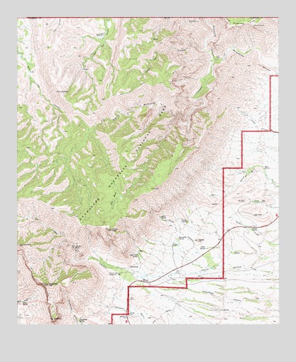
Guadalupe Peak, TX USGS Topographic Map
Click on map above to begin viewing in our Map Viewer.

This topographic map contains these locations and features:
Feature Name Type Latitude Longitude GNIS ID View Map
Bell SpringSpringN31.9385°W104.7573°1351844View Map
Bone SpringSpringN31.8846°W104.8727°1352647View Map
Bowl TrailTrailN31.9162°W104.8363°2032947View Map
Choza SpringSpringN31.9059°W104.7858°1354466View Map
Devils Den CanyonValleyN31.9868°W104.7860°1355959View Map
Devils HallBasinN31.9068°W104.8474°1355962View Map
Dog Canyon Ranger StationLocaleN31.9929°W104.8344°1356117View Map
El CapitanSummitN31.8775°W104.8582°1356864View Map
Frijole (historical)Populated PlaceN31.9054°W104.7830°2034634View Map
Frijole RanchLocaleN31.9076°W104.8008°1357761View Map
Guadalupe MountainsRangeN31.8912°W104.8605°912587View Map
Guadalupe Mountains National Park Fire DepartmentBuildingN31.8908°W104.8117°2551371View Map
Guadalupe Mountains WildernessReserveN31.9518°W104.8480°2035141View Map
Guadalupe PeakSummitN31.8914°W104.8607°1358489View Map
Guadalupe RanchLocaleN31.9076°W104.8005°2032113View Map
Guadalupe SpringSpringN31.8770°W104.8458°1358493View Map
Hunter PeakSummitN31.9138°W104.8303°1359842View Map
Juniper SpringSpringN31.9173°W104.7943°1360472View Map
Ligon RanchLocaleN31.9248°W104.7586°1361189View Map
Lost PeakSummitN31.9701°W104.8549°1361837View Map
Manzanita SpringSpringN31.9104°W104.7983°1362156View Map
Marcus TrailTrailN31.9618°W104.8677°2033428View Map
McKittrick CanyonValleyN31.9787°W104.7520°1350808View Map
Nipple HillSummitN31.9094°W104.7891°1363912View Map
North McKittrick CanyonValleyN31.9827°W104.7806°909171View Map
Pine SpringSpringN31.8987°W104.8220°1365309View Map
Pine Spring CampgroundLocaleN31.8959°W104.8274°1365310View Map
Pine Spring CanyonValleyN31.8948°W104.8181°1365311View Map
Pine SpringsSpringN31.9084°W104.8255°1998687View Map
Pine SpringsPopulated PlaceN31.8926°W104.8155°1380360View Map
Pinery (historical)Populated PlaceN31.8926°W104.8174°2034657View Map
Pinery StationLocaleN31.8940°W104.8174°2032050View Map
Pratt ArchArchN31.9567°W104.7925°2678375View Map
Rader RidgeRidgeN31.9282°W104.7910°1365942View Map
Shumard PeakSummitN31.9076°W104.8744°1368245View Map
Smith CanyonValleyN31.9055°W104.7742°1368462View Map
Smith SpringSpringN31.9188°W104.8071°1368504View Map
Soldier SpringSpringN31.9140°W104.7635°1368594View Map
South McKittrick CanyonValleyN31.9829°W104.7804°1368717View Map
Tejas ArchArchN31.9064°W104.8369°2678373View Map
Tejas TrailTrailN31.9882°W104.8358°2033153View Map
The BowlBasinN31.9257°W104.8286°1369770View Map
Upper Pine SpringSpringN31.9032°W104.8178°1370520View Map
Wallace Pratt LodgeParkN31.9836°W104.7806°1365750View Map
Wilderness Ridge - Shumard TrailTrailN31.9973°W104.7686°2033109View Map

Note: Coordinates in the location and feature list above are referenced to NAD83 datum.


Copyright (C) 2008-2024 Ryan Niemi / Sunset Dynamics ... All Rights Reserved