TopoQuest Logo
Do you find TopoQuest useful?
Help keep TopoQuest running and adding new maps/features by donating!
Bitcoin:  19c7KJd3qBynnjoSw5npx9KScwjBe4ifkT
Litecoin:  LXs6TkuXGGXo1vDsWCkWVdjQX94eUKd6ui
Home View Maps Find Maps Find Places Resources & Links


Gunsight Canyon, New Mexico Topographic Map

USGS Map Title: Gunsight Canyon, NM
USGS Map MRC: 32104A6
DRG (GeoTIFF) Download: o32104a6.tif


Neighboring USGS Topographic Map Quads:


  Pickett Hill, NM  
32104B7
 

  Queen, NM  
32104B6
 

  Serpentine Bends, NM  
32104B5
 

  El Paso Gap, NM  
32104A7
 

  Gunsight Canyon, NM  
32104A6
 

  Grapevine Draw, NM  
32104A5
 

  Guadalupe Peak, TX  
31104H7
 

  Independence Spring, TX  
31104H6
 

  South Rector Canyon, TX  
31104H5


Map MRC Location:

N33°
W105°
N33°
W104°
H8 H7 H6 H5 H4 H3 H2 H1
G8 G7 G6 G5 G4 G3 G2 G1
F8 F7 F6 F5 F4 F3 F2 F1
E8 E7 E6 E5 E4 E3 E2 E1
D8 D7 D6 D5 D4 D3 D2 D1
C8 C7 C6 C5 C4 C3 C2 C1
B8 B7 B6 B5 B4 B3 B2 B1
A8 A7 A6 A5 A4 A3 A2 A1
N32°
W105°
N32°
W104°

Gunsight Canyon, NM USGS 1:24K Topographic Map Preview:
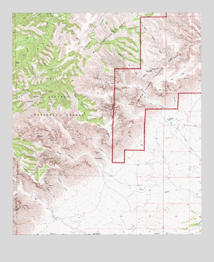
Gunsight Canyon, NM USGS Topographic Map
Click on map above to begin viewing in our Map Viewer.

This topographic map contains these locations and features:
Feature Name Type Latitude Longitude GNIS ID View Map
Aqua Dulce SeepSpringN32.1192°W104.6902°913275View Map
Black CanyonValleyN32.0362°W104.6913°903853View Map
Calamity CoveValleyN32.0131°W104.7068°904299View Map
Cave CanyonValleyN32.1215°W104.7135°904842View Map
Dark Canyon Lookout TowerTowerN32.0815°W104.7400°913277View Map
Double TrailTrailN32.0971°W104.6744°905838View Map
Franks CanyonValleyN32.0576°W104.7347°906378View Map
Franks SpringSpringN32.0430°W104.6965°906383View Map
Goat CanyonValleyN32.1229°W104.7230°906579View Map
Golden Stairway TrailTrailN32.0279°W104.7277°906624View Map
Gunsight CanyonValleyN32.0386°W104.6857°906780View Map
Helton CreekStreamN32.1073°W104.7469°906922View Map
Helton TankReservoirN32.0970°W104.7456°906923View Map
Hidden SeepSpringN32.0753°W104.7413°906954View Map
Lefthook CanyonValleyN32.0695°W104.6411°907929View Map
Lonesome Ridge Wilderness Study AreaParkN32.0162°W104.7422°935852View Map
Middle Fork Big CanyonValleyN32.0318°W104.7497°908692View Map
Munson ReservationLocaleN32.1143°W104.6819°908988View Map
North Fork Big CanyonValleyN32.0260°W104.7457°909137View Map
Old Helper RanchLocaleN32.1212°W104.7191°913353View Map
Open Hollow GulchValleyN32.0994°W104.6431°909359View Map
Pacific SlopeRidgeN32.0820°W104.7112°909425View Map
South SeepSpringN32.0968°W104.7325°1983630View Map
Spring CanyonValleyN32.1167°W104.7146°911309View Map
Spring SeepSpringN32.1118°W104.7097°913274View Map
Stone CanyonValleyN32.1248°W104.7282°911429View Map
Thurman TanksReservoirN32.0649°W104.6476°911694View Map
Ussery TrailTrailN32.0748°W104.7061°912011View Map
Wild Cow MesaSummitN32.0638°W104.6981°912369View Map
XT SpringSpringN32.0060°W104.6298°912511View Map

Note: Coordinates in the location and feature list above are referenced to NAD83 datum.


Copyright (C) 2008-2025 Ryan Niemi / Sunset Dynamics ... All Rights Reserved