TopoQuest Logo
Do you find TopoQuest useful?
Help keep TopoQuest running and adding new maps/features by donating!
Bitcoin:  19c7KJd3qBynnjoSw5npx9KScwjBe4ifkT
Litecoin:  LXs6TkuXGGXo1vDsWCkWVdjQX94eUKd6ui
Home View Maps Find Maps Find Places Resources & Links


Gueydan, Louisiana Topographic Map

USGS Map Title: Gueydan, LA
USGS Map MRC: 30092A5
DRG (GeoTIFF) Download: o30092a5.tif


Neighboring USGS Topographic Map Quads:


  Jennings, LA  
30092B6
 

  Mermentau, LA  
30092B5
 

  Crowley West, LA  
30092B4
 

  Lake Arthur, LA  
30092A6
 

  Gueydan, LA  
30092A5
 

  Wright, LA  
30092A4


Map MRC Location:

N31°
W93°
N31°
W92°
H8 H7 H6 H5 H4 H3 H2 H1
G8 G7 G6 G5 G4 G3 G2 G1
F8 F7 F6 F5 F4 F3 F2 F1
E8 E7 E6 E5 E4 E3 E2 E1
D8 D7 D6 D5 D4 D3 D2 D1
C8 C7 C6 C5 C4 C3 C2 C1
B8 B7 B6 B5 B4 B3 B2 B1
A8 A7 A6 A5 A4 A3 A2 A1
N30°
W93°
N30°
W92°

Gueydan, LA USGS 1:24K Topographic Map Preview:
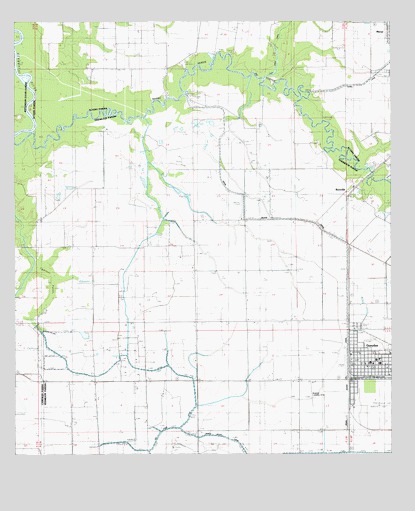
Gueydan, LA USGS Topographic Map
Click on map above to begin viewing in our Map Viewer.

This topographic map contains these locations and features:
Feature Name Type Latitude Longitude GNIS ID View Map
Boatner Landing StripAirportN30.0174°W92.5265°557071View Map
Cypress PointSwampN30.0493°W92.6125°534375View Map
First Baptist ChurchChurchN30.0255°W92.5082°544198View Map
GueydanPopulated PlaceN30.0260°W92.5085°543266View Map
Gueydan Elementary School (historical)SchoolN30.0272°W92.5051°544208View Map
Gueydan Fire DepartmentBuildingN30.0255°W92.5101°2332587View Map
Gueydan Head Start SchoolSchoolN30.0255°W92.5013°2600222View Map
Gueydan High SchoolSchoolN30.0263°W92.5040°544209View Map
Gueydan Museum and Cultural Arts CenterBuildingN30.0255°W92.5115°2603215View Map
Gueydan Police DepartmentBuildingN30.0254°W92.5095°2334125View Map
Gueydan Post OfficePost OfficeN30.0260°W92.5099°1630071View Map
Gueydan Sewage Treatment FacilityLocaleN30.0294°W92.5001°2603435View Map
Gueydan United Methodist ChurchChurchN30.0258°W92.5090°544210View Map
Hubbard United Church of ChristChurchN30.0230°W92.5010°544217View Map
Istre CemeteryCemeteryN30.1160°W92.5654°535968View Map
Lazy Point CanalCanalN30.1222°W92.5365°536365View Map
Moon Island CanalCanalN30.0130°W92.5146°537188View Map
Morse Water Treatment FacilityLocaleN30.1085°W92.5079°2603383View Map
RicevillePopulated PlaceN30.0763°W92.5143°555797View Map
Riceville BridgeBridgeN30.0813°W92.5062°544269View Map
Riceville Gas FieldOilfieldN30.0822°W92.5532°538581View Map
Saint Peter Catholic ChurchChurchN30.0260°W92.5062°544280View Map
Saint Peter SchoolSchoolN30.0266°W92.5074°544281View Map
South Riceville Gas FieldOilfieldN30.0460°W92.5565°544292View Map
Town of GueydanCivilN30.0290°W92.5070°2406625View Map
Venissat AirstripAirportN30.0897°W92.5322°2676766View Map
Vermilion Parish Library Gueydan BranchBuildingN30.0282°W92.5037°2603166View Map
Ward EightCivilN30.0241°W92.5090°545245View Map
West Gueydan Oil and Gas FieldOilfieldN30.0230°W92.5843°540325View Map

Note: Coordinates in the location and feature list above are referenced to NAD83 datum.


Copyright (C) 2008-2024 Ryan Niemi / Sunset Dynamics ... All Rights Reserved