TopoQuest Logo
Do you find TopoQuest useful?
Help keep TopoQuest running and adding new maps/features by donating!
Bitcoin:  19c7KJd3qBynnjoSw5npx9KScwjBe4ifkT
Litecoin:  LXs6TkuXGGXo1vDsWCkWVdjQX94eUKd6ui
Home View Maps Find Maps Find Places Resources & Links


Wright, Louisiana Topographic Map

USGS Map Title: Wright, LA
USGS Map MRC: 30092A4
DRG (GeoTIFF) Download: o30092a4.tif


Neighboring USGS Topographic Map Quads:


  Mermentau, LA  
30092B5
 

  Crowley West, LA  
30092B4
 

  Crowley East, LA  
30092B3
 

  Gueydan, LA  
30092A5
 

  Wright, LA  
30092A4
 

  Kaplan North, LA  
30092A3


Map MRC Location:

N31°
W93°
N31°
W92°
H8 H7 H6 H5 H4 H3 H2 H1
G8 G7 G6 G5 G4 G3 G2 G1
F8 F7 F6 F5 F4 F3 F2 F1
E8 E7 E6 E5 E4 E3 E2 E1
D8 D7 D6 D5 D4 D3 D2 D1
C8 C7 C6 C5 C4 C3 C2 C1
B8 B7 B6 B5 B4 B3 B2 B1
A8 A7 A6 A5 A4 A3 A2 A1
N30°
W93°
N30°
W92°

Wright, LA USGS 1:24K Topographic Map Preview:
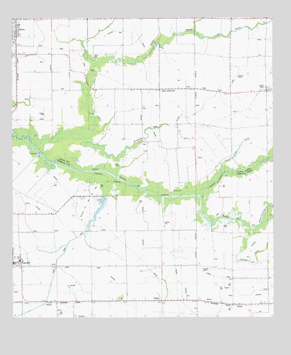
Wright, LA USGS Topographic Map
Click on map above to begin viewing in our Map Viewer.

This topographic map contains these locations and features:
Feature Name Type Latitude Longitude GNIS ID View Map
Acadia Parish Library Morse BranchBuildingN30.1232°W92.4994°2603014View Map
Avrico CanalCanalN30.0216°W92.4379°532261View Map
Bayou Grand MaraisStreamN30.0391°W92.3815°553463View Map
Castille GullyStreamN30.0377°W92.3862°544180View Map
Coulee Des IlesStreamN30.0513°W92.4104°534174View Map
East Gueydan Oil and Gas FieldOilfieldN30.0549°W92.3921°544191View Map
Ferre CanalCanalN30.0991°W92.4512°534939View Map
Gueydan Oil and Gas FieldOilfieldN30.0424°W92.4682°535438View Map
Hanks CemeteryCemeteryN30.1096°W92.4615°535518View Map
Jesse Owens Elementary SchoolSchoolN30.0232°W92.4996°1629859View Map
Le Blanc School (historical)SchoolN30.1188°W92.4210°544722View Map
Leger CemeteryCemeteryN30.0480°W92.4396°544233View Map
Lyons PointPopulated PlaceN30.0946°W92.3782°536789View Map
Lyons Point GullyStreamN30.1072°W92.4451°536790View Map
Lyons Point School (historical)SchoolN30.0955°W92.4515°544726View Map
Maree Michel CanalCanalN30.0044°W92.4907°536895View Map
Merrit Landing Strip (historical)AirportN30.0952°W92.4254°1630076View Map
MorsePopulated PlaceN30.1219°W92.4982°555378View Map
Morse Post OfficePost OfficeN30.1243°W92.4973°1630111View Map
MulveyPopulated PlaceN30.0063°W92.4040°541148View Map
Prime GullyStreamN30.0608°W92.3999°538405View Map
Saint Johns ChurchChurchN30.0952°W92.3779°544409View Map
Simmons GullyStreamN30.0733°W92.4643°539386View Map
Simon CemeteryCemeteryN30.0641°W92.4493°539388View Map
Sixteenth Section School (historical)SchoolN30.0941°W92.3782°544743View Map
Village of MorseCivilN30.1221°W92.4984°2407507View Map
WrightPopulated PlaceN30.0074°W92.4287°556477View Map
Wright Oil and Gas FieldOilfieldN30.0083°W92.3876°544309View Map
Wright Post Office (historical)Post OfficeN30.0069°W92.4285°1631620View Map

Note: Coordinates in the location and feature list above are referenced to NAD83 datum.


Copyright (C) 2008-2025 Ryan Niemi / Sunset Dynamics ... All Rights Reserved