TopoQuest Logo
Do you find TopoQuest useful?
Help keep TopoQuest running and adding new maps/features by donating!
Bitcoin:  19c7KJd3qBynnjoSw5npx9KScwjBe4ifkT
Litecoin:  LXs6TkuXGGXo1vDsWCkWVdjQX94eUKd6ui
Home View Maps Find Maps Find Places Resources & Links


Lake Arthur, Louisiana Topographic Map

USGS Map Title: Lake Arthur, LA
USGS Map MRC: 30092A6
DRG (GeoTIFF) Download: o30092a6.tif


Neighboring USGS Topographic Map Quads:


  Welsh South, LA  
30092B7
 

  Jennings, LA  
30092B6
 

  Mermentau, LA  
30092B5
 

  Thornwell, LA  
30092A7
 

  Lake Arthur, LA  
30092A6
 

  Gueydan, LA  
30092A5


Map MRC Location:

N31°
W93°
N31°
W92°
H8 H7 H6 H5 H4 H3 H2 H1
G8 G7 G6 G5 G4 G3 G2 G1
F8 F7 F6 F5 F4 F3 F2 F1
E8 E7 E6 E5 E4 E3 E2 E1
D8 D7 D6 D5 D4 D3 D2 D1
C8 C7 C6 C5 C4 C3 C2 C1
B8 B7 B6 B5 B4 B3 B2 B1
A8 A7 A6 A5 A4 A3 A2 A1
N30°
W93°
N30°
W92°

Lake Arthur, LA USGS 1:24K Topographic Map Preview:
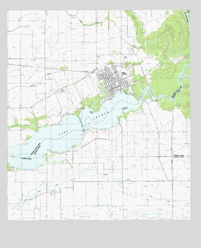
Lake Arthur, LA USGS Topographic Map
Click on map above to begin viewing in our Map Viewer.

This topographic map contains these locations and features:
Feature Name Type Latitude Longitude GNIS ID View Map
Andress CoveStreamN30.1002°W92.6276°532169View Map
Andress Cove CemeteryCemeteryN30.1074°W92.6632°532170View Map
Antioch Baptist ChurchChurchN30.0859°W92.6862°2600536View Map
Bayou Queue de TortueStreamN30.0927°W92.6260°559653View Map
First Baptist ChurchChurchN30.0791°W92.6751°2601742View Map
First United Methodist ChurchChurchN30.0785°W92.6813°2601992View Map
Gaithes PointCapeN30.0647°W92.6904°535148View Map
Jefferson Davis Parish Library Lake Arthur BranchBuildingN30.0803°W92.6780°2603076View Map
Klondike CanalCanalN30.0297°W92.6960°536218View Map
Klondike SchoolSchoolN30.0235°W92.6371°536221View Map
Klondike Volunteer Fire DepartmentBuildingN30.0231°W92.6373°2332487View Map
Lake Air ServiceAirportN30.0945°W92.6978°2676786View Map
Lake ArthurLakeN30.0343°W92.7329°559623View Map
Lake ArthurPopulated PlaceN30.0808°W92.6715°543371View Map
Lake Arthur Elementary SchoolSchoolN30.0844°W92.6766°545857View Map
Lake Arthur Fire DepartmentBuildingN30.0849°W92.6969°2332395View Map
Lake Arthur High SchoolSchoolN30.0969°W92.6694°545858View Map
Lake Arthur Police StationBuildingN30.0801°W92.6786°2334000View Map
Lake Arthur Post OfficePost OfficeN30.0788°W92.6770°1630367View Map
Lake Arthur Volunteer Fire DepartmentBuildingN30.0848°W92.6810°2332356View Map
Laurents PastureFlatN30.0583°W92.6721°558914View Map
Laurents PointCapeN30.0658°W92.6715°536357View Map
Laurents PointPopulated PlaceN30.0619°W92.6710°544232View Map
Mitchell BayouStreamN30.0530°W92.7285°537164View Map
Our Lady of the Lake ChurchChurchN30.0767°W92.6794°2602553View Map
Rivillons PastureFlatN30.0394°W92.6901°558916View Map
Rivillons Wharf (historical)LocaleN30.0555°W92.6951°558917View Map
Saint Theresa ChurchChurchN30.0647°W92.6571°539076View Map
South Lake Arthur Gas FieldOilfieldN30.0530°W92.6835°544291View Map
South Lake Arthur Gas FieldOilfieldN30.0947°W92.6571°545876View Map
Talens Marine and Fuel Lake Arthur DockLocaleN30.0775°W92.6726°2601237View Map
The NarrowsGutN30.0549°W92.6968°539855View Map
Town of Lake ArthurCivilN30.0795°W92.6773°2405969View Map
Ward OneCivilN30.0899°W92.6835°545079View Map
West Lake Arthur Gas FieldOilfieldN30.0780°W92.7154°558363View Map
West Lake Arthur Oil FieldOilfieldN30.0755°W92.7138°540326View Map

Note: Coordinates in the location and feature list above are referenced to NAD83 datum.


Copyright (C) 2008-2025 Ryan Niemi / Sunset Dynamics ... All Rights Reserved