TopoQuest Logo
Do you find TopoQuest useful?
Help keep TopoQuest running and adding new maps/features by donating!
Bitcoin:  19c7KJd3qBynnjoSw5npx9KScwjBe4ifkT
Litecoin:  LXs6TkuXGGXo1vDsWCkWVdjQX94eUKd6ui
Home View Maps Find Maps Find Places Resources & Links


Aurora, Ohio Topographic Map

USGS Map Title: Aurora, OH
USGS Map MRC: 41081C3
DRG (GeoTIFF) Download: o41081c3.tif


Neighboring USGS Topographic Map Quads:


  Chagrin Falls, OH  
41081D4
 

  South Russell, OH  
41081D3
 

  Burton, OH  
41081D2
 

  Twinsburg, OH  
41081C4
 

  Aurora, OH  
41081C3
 

  Mantua, OH  
41081C2
 

  Hudson, OH  
41081B4
 

  Kent, OH  
41081B3
 

  Ravenna, OH  
41081B2


Map MRC Location:

N42°
W82°
N42°
W81°
H8 H7 H6 H5 H4 H3 H2 H1
G8 G7 G6 G5 G4 G3 G2 G1
F8 F7 F6 F5 F4 F3 F2 F1
E8 E7 E6 E5 E4 E3 E2 E1
D8 D7 D6 D5 D4 D3 D2 D1
C8 C7 C6 C5 C4 C3 C2 C1
B8 B7 B6 B5 B4 B3 B2 B1
A8 A7 A6 A5 A4 A3 A2 A1
N41°
W82°
N41°
W81°

Aurora, OH USGS 1:24K Topographic Map Preview:
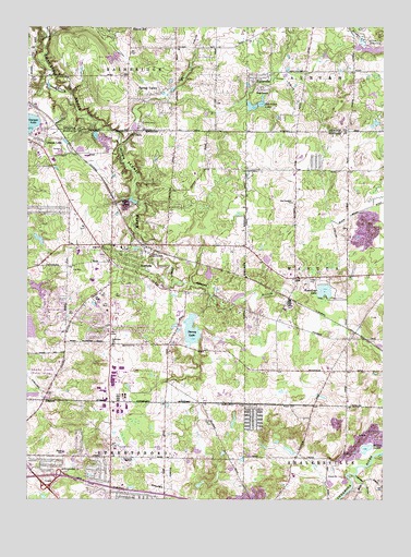
Aurora, OH USGS Topographic Map
Click on map above to begin viewing in our Map Viewer.

This topographic map contains these locations and features:
Feature Name Type Latitude Longitude GNIS ID View Map
Ashbrook FarmLocaleN41.3611°W81.2819°2547146View Map
AuroraPopulated PlaceN41.3176°W81.3454°1064359View Map
Aurora CemeteryCemeteryN41.3148°W81.3490°1963994View Map
Aurora Center Historic DistrictParkN41.3153°W81.3457°1077456View Map
Aurora Country ClubLocaleN41.3151°W81.3329°1080033View Map
Aurora Fire Department Station 1BuildingN41.3125°W81.3483°2550405View Map
Aurora High SchoolSchoolN41.3078°W81.3521°1058303View Map
Aurora Police DepartmentBuildingN41.3146°W81.3475°2732509View Map
Aurora Post OfficePost OfficeN41.3181°W81.3457°2043848View Map
Aurora Post Office (historical)Post OfficeN41.3181°W81.3457°2056316View Map
Aurora Station (historical)LocaleN41.3173°W81.3346°1058299View Map
BeartownPopulated PlaceN41.3584°W81.2901°1048499View Map
Beartown Lake DamDamN41.3546°W81.2979°1078246View Map
Beartown LakesReservoirN41.3540°W81.2965°1070673View Map
Camelot VillagePopulated PlaceN41.2639°W81.3406°2513576View Map
City of AuroraCivilN41.3119°W81.3450°1086822View Map
Colebrook LakeReservoirN41.2955°W81.3742°1078793View Map
Colebrook Lake DamDamN41.2934°W81.3748°1078792View Map
Craddock Elementary SchoolSchoolN41.3167°W81.3421°1058300View Map
Crestwood-Laraham SchoolSchoolN41.2562°W81.2812°1058298View Map
Fowler CemeteryCemeteryN41.3614°W81.3229°1040627View Map
Geauga LakeLakeN41.3494°W81.3739°1040805View Map
Geauga Lake Wild Water Kingdom Emergency Medical ServicesBuildingN41.3465°W81.3687°2550836View Map
Hannum Airport (historical)AirportN41.2645°W81.3273°1083034View Map
Harmon Middle SchoolSchoolN41.3153°W81.3568°1058301View Map
Henry CemeteryCemeteryN41.3548°W81.3593°1963338View Map
Hollow LakesLakeN41.2633°W81.2577°1041670View Map
Interchange 13CrossingN41.2562°W81.3637°1080246View Map
Julia (historical)Populated PlaceN41.3476°W81.2626°1065701View Map
Julia Post Office (historical)Post OfficeN41.3473°W81.2623°1988344View Map
Lower Bear LakeReservoirN41.3540°W81.2965°1840243View Map
Melco LakeLakeN41.3290°W81.3380°1043211View Map
Middle Bear LakeReservoirN41.3547°W81.2931°1840244View Map
Miller Elementary SchoolSchoolN41.3109°W81.3507°1058302View Map
Minnow PondLakeN41.3552°W81.2909°1840245View Map
Plainview CemeteryCemeteryN41.2912°W81.3445°1964005View Map
Round-up LakeLakeN41.3053°W81.2707°1045223View Map
SiloPopulated PlaceN41.3089°W81.2812°1063018View Map
Silo Post Office (historical)Post OfficeN41.3084°W81.2818°2055551View Map
Spring CreekStreamN41.3567°W81.3268°1840246View Map
Spring ValleyPopulated PlaceN41.3562°W81.3398°1049202View Map
Sunny LakeLakeN41.2948°W81.3172°1046862View Map
TaborvillePopulated PlaceN41.3617°W81.2954°1049239View Map
The Country ChurchChurchN41.3284°W81.2818°1047005View Map
Twinsburg Post OfficePost OfficeN41.3126°W81.2743°2056320View Map
Upper Bear LakeReservoirN41.3564°W81.2926°1840242View Map
Waite Elementary SchoolSchoolN41.2628°W81.3621°1084082View Map
Walden DamDamN41.3067°W81.3748°1079319View Map
Walden LakeReservoirN41.3056°W81.3710°1079320View Map
Wintergreen Tree FarmLocaleN41.3358°W81.2528°2650304View Map
YMCA CampLocaleN41.3498°W81.3348°1048391View Map

Note: Coordinates in the location and feature list above are referenced to NAD83 datum.


Copyright (C) 2008-2024 Ryan Niemi / Sunset Dynamics ... All Rights Reserved