TopoQuest Logo
Do you find TopoQuest useful?
Help keep TopoQuest running and adding new maps/features by donating!
Bitcoin:  19c7KJd3qBynnjoSw5npx9KScwjBe4ifkT
Litecoin:  LXs6TkuXGGXo1vDsWCkWVdjQX94eUKd6ui
Home View Maps Find Maps Find Places Resources & Links


South Russell, Ohio Topographic Map

USGS Map Title: South Russell, OH
USGS Map MRC: 41081D3
DRG (GeoTIFF) Download: o41081d3.tif


Neighboring USGS Topographic Map Quads:


  Mayfield Heights, OH  
41081E4
 

  Chesterland, OH  
41081E3
 

  Chardon, OH  
41081E2
 

  Chagrin Falls, OH  
41081D4
 

  South Russell, OH  
41081D3
 

  Burton, OH  
41081D2
 

  Twinsburg, OH  
41081C4
 

  Aurora, OH  
41081C3
 

  Mantua, OH  
41081C2


Map MRC Location:

N42°
W82°
N42°
W81°
H8 H7 H6 H5 H4 H3 H2 H1
G8 G7 G6 G5 G4 G3 G2 G1
F8 F7 F6 F5 F4 F3 F2 F1
E8 E7 E6 E5 E4 E3 E2 E1
D8 D7 D6 D5 D4 D3 D2 D1
C8 C7 C6 C5 C4 C3 C2 C1
B8 B7 B6 B5 B4 B3 B2 B1
A8 A7 A6 A5 A4 A3 A2 A1
N41°
W82°
N41°
W81°

South Russell, OH USGS 1:24K Topographic Map Preview:
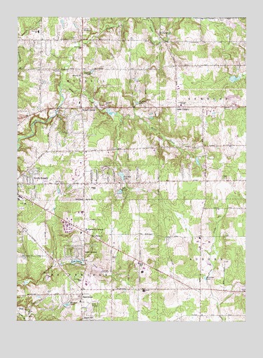
South Russell, OH USGS Topographic Map
Click on map above to begin viewing in our Map Viewer.

This topographic map contains these locations and features:
Feature Name Type Latitude Longitude GNIS ID View Map
Auburn AirportAirportN41.4114°W81.2817°1082558View Map
Auburn Industrial ParkLocaleN41.4081°W81.2708°2547139View Map
Auburn Pointe GreenhousesBuildingN41.3886°W81.2814°2630671View Map
BainbridgePopulated PlaceN41.3864°W81.3396°1064373View Map
Bainbridge Census Designated PlaceCensusN41.3944°W81.3366°2393325View Map
Bainbridge Community ChurchChurchN41.3859°W81.3390°1963327View Map
Bainbridge Township Fire DepartmentBuildingN41.3843°W81.3399°2550533View Map
Bainbridge Township PoliceBuildingN41.3849°W81.3432°2732914View Map
Beacon HillPopulated PlaceN41.3756°W81.3387°1048494View Map
Bellwood LakeReservoirN41.4380°W81.3272°1078252View Map
Bellwood Lake DamDamN41.4386°W81.3265°1078251View Map
Beudale (historical)Populated PlaceN41.4901°W81.2748°1067572View Map
Briar Hill CemeteryCemeteryN41.4904°W81.3417°1963329View Map
Briar Hill CornersPopulated PlaceN41.4906°W81.3398°1067573View Map
Chagrin Falls Airport (historical)AirportN41.4289°W81.3315°1988518View Map
Chagrin Valley FarmsLocaleN41.4039°W81.3119°2547144View Map
Cross Creek Industrial ParkLocaleN41.4594°W81.2681°2547142View Map
Crosswind FarmLocaleN41.4200°W81.2761°2547143View Map
Derecsky AirportAirportN41.3757°W81.2568°1082472View Map
Eagle Park Country ClubLocaleN41.3956°W81.3248°1080085View Map
Eastview LakeLakeN41.3928°W81.2720°1040037View Map
Fairweathers FarmLocaleN41.3756°W81.2819°2547145View Map
Faith Baptist ChurchChurchN41.4797°W81.3405°2723894View Map
Fullerton Post Office (historical)Post OfficeN41.4931°W81.2984°1988337View Map
FullertownPopulated PlaceN41.4926°W81.2984°1064693View Map
Gardiner Elementary SchoolSchoolN41.3878°W81.3059°1081343View Map
Gottschalk Industrial ParkLocaleN41.4028°W81.2764°2547140View Map
Kenston High SchoolSchoolN41.3956°W81.3065°1042230View Map
Kenston Intermediate SchoolSchoolN41.3831°W81.3401°1057751View Map
Kenston LakeReservoirN41.3818°W81.3474°1078258View Map
Kenston Lake DamDamN41.3810°W81.3489°1078257View Map
Kenston Middle SchoolSchoolN41.3967°W81.3057°1057752View Map
Kingdom Hall ChurchChurchN41.4101°W81.3337°1042276View Map
Knowles Industrial ParkLocaleN41.4131°W81.3483°2547141View Map
Lake LouiseReservoirN41.4283°W81.3187°1078254View Map
Lake Louise DamDamN41.4290°W81.3179°1078253View Map
Lake LucernePopulated PlaceN41.4051°W81.3382°1048895View Map
Lake LucerneReservoirN41.3994°W81.3426°1078248View Map
Lake Lucerne DamDamN41.3993°W81.3452°1078247View Map
Lake TaylorLakeN41.3798°W81.3349°1046973View Map
Lighthouse for God ChurchChurchN41.4153°W81.3462°1042562View Map
Matthew Cemetery (historical)CemeteryN41.4451°W81.3387°1963341View Map
McConoughey Cemetery (historical)CemeteryN41.3998°W81.3079°1963342View Map
McConougheys HillSummitN41.4051°W81.3015°1067578View Map
McFarlands CornersPopulated PlaceN41.4117°W81.3382°1043106View Map
Morton CemeteryCemeteryN41.4342°W81.2621°1043502View Map
Munn CemeteryCemeteryN41.4467°W81.2779°1043734View Map
NoveltyPopulated PlaceN41.4948°W81.3407°1049029View Map
Novelty LakeLakeN41.4777°W81.3343°1044009View Map
Novelty NurseryBuildingN41.4758°W81.3422°2651843View Map
Novelty Post OfficePost OfficeN41.4759°W81.3409°1044010View Map
Ohnoname 15 DamDamN41.4417°W81.2765°1078255View Map
Ohnoname 15 ReservoirReservoirN41.4409°W81.2765°1078256View Map
Old Bainbridge CemeteryCemeteryN41.4014°W81.3370°1963346View Map
Paw Paw LakeReservoirN41.4348°W81.3177°1079356View Map
Paw Paw Lake DamDamN41.4351°W81.3182°1079355View Map
Queens Industrial ParkLocaleN41.3981°W81.2786°2547138View Map
Rataiczak AirportAirportN41.4773°W81.3173°1082986View Map
Red Raider CampLocaleN41.4648°W81.3279°1044899View Map
Red Wing CampLocaleN41.4776°W81.3529°1044904View Map
Restland CemeteryCemeteryN41.3862°W81.3370°1963352View Map
Riverview CemeteryCemeteryN41.4916°W81.3430°1045069View Map
Riverview ChurchChurchN41.4876°W81.3412°1045071View Map
Russell CenterPopulated PlaceN41.4626°W81.3407°1065261View Map
Russell Post Office (historical)Post OfficeN41.4626°W81.3401°1988360View Map
Russell Township Fire DepartmentBuildingN41.4652°W81.3409°2549436View Map
Silver CreekStreamN41.4723°W81.3518°1046273View Map
Snake Hill FarmLocaleN41.3756°W81.3692°2570569View Map
South RussellPopulated PlaceN41.4314°W81.3654°1049194View Map
South Russell CemeteryCemeteryN41.4312°W81.3504°1046496View Map
Tanglewood LakeReservoirN41.3967°W81.3382°1078250View Map
Tanglewood Lake DamDamN41.3967°W81.3382°1078249View Map
Tanglewood Square Shopping CenterLocaleN41.4117°W81.3365°1069487View Map
Township of BainbridgeCivilN41.3863°W81.3447°1086148View Map
Township of RussellCivilN41.4693°W81.3418°1086160View Map
Valley Presbyterian ChurchChurchN41.3920°W81.3401°1047013View Map
Village of South RussellCivilN41.4318°W81.3351°2399857View Map
Vincent Cemetery (historical)CemeteryN41.4128°W81.3718°1963357View Map
Westwood Elementary SchoolSchoolN41.4939°W81.3640°1082053View Map
Wiegand LakeLakeN41.4647°W81.3093°1047897View Map
WKHR-FM (Bainbridge)TowerN41.3951°W81.3068°1083773View Map
WPHR-FM (Cleveland)TowerN41.4651°W81.2868°1083803View Map
WPHR-FM (Cleveland)TowerN41.4676°W81.2901°1083804View Map
Yates CornersPopulated PlaceN41.4631°W81.2887°1080510View Map

Note: Coordinates in the location and feature list above are referenced to NAD83 datum.


Copyright (C) 2008-2025 Ryan Niemi / Sunset Dynamics ... All Rights Reserved