TopoQuest Logo
Do you find TopoQuest useful?
Help keep TopoQuest running and adding new maps/features by donating!
Bitcoin:  19c7KJd3qBynnjoSw5npx9KScwjBe4ifkT
Litecoin:  LXs6TkuXGGXo1vDsWCkWVdjQX94eUKd6ui
Home View Maps Find Maps Find Places Resources & Links


Guttenberg, Iowa Topographic Map

USGS Map Title: Guttenberg, IA
USGS Map MRC: 42091G1
DRG (GeoTIFF) Download: o42091g1.tif


Neighboring USGS Topographic Map Quads:


  Clayton, IA  
42091H2
 

  Brodtville, WI  
42091H1
 

  Bloomington, WI  
42090H8
 

  Garnavillo, IA  
42091G2
 

  Guttenberg, IA  
42091G1
 

  Beetown, WI  
42090G8
 

  Colesburg, IA  
42091F2
 

  Turkey River, IA  
42091F1
 

  Cassville, WI  
42090F8


Map MRC Location:

N43°
W92°
N43°
W91°
H8 H7 H6 H5 H4 H3 H2 H1
G8 G7 G6 G5 G4 G3 G2 G1
F8 F7 F6 F5 F4 F3 F2 F1
E8 E7 E6 E5 E4 E3 E2 E1
D8 D7 D6 D5 D4 D3 D2 D1
C8 C7 C6 C5 C4 C3 C2 C1
B8 B7 B6 B5 B4 B3 B2 B1
A8 A7 A6 A5 A4 A3 A2 A1
N42°
W92°
N42°
W91°

Guttenberg, IA USGS 1:24K Topographic Map Preview:
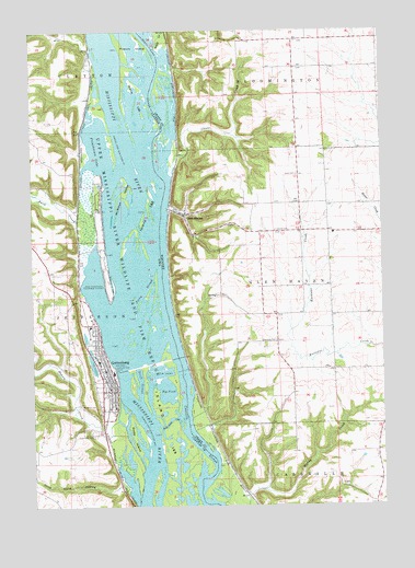
Guttenberg, IA USGS Topographic Map
Click on map above to begin viewing in our Map Viewer.

This topographic map contains these locations and features:
Feature Name Type Latitude Longitude GNIS ID View Map
Abel-Essman IslandIslandN42.8192°W91.1004°2746998View Map
Ackerman CutGutN42.7728°W91.0765°454082View Map
Big PondReservoirN42.7820°W91.0821°454620View Map
Buck CreekStreamN42.8369°W91.1071°454920View Map
Bussey LakeLakeN42.8058°W91.1047°2729979View Map
Cassville SloughChannelN42.7692°W91.0701°455205View Map
Charlotte CemeteryCemeteryN42.7933°W91.0382°1562958View Map
Chase CreekStreamN42.8372°W91.0760°1562961View Map
City of GuttenbergCivilN42.7887°W91.1059°2394262View Map
Clayton Ridge Elementary SchoolSchoolN42.7852°W91.0965°2719854View Map
Clayton Ridge High SchoolSchoolN42.7845°W91.0962°1949153View Map
Duck LakeLakeN42.8742°W91.0905°2729975View Map
EckardsPopulated PlaceN42.8564°W91.1043°464088View Map
Eckards (historical)LocaleN42.8564°W91.1043°1949009View Map
Family Medicine Associates CenterHospitalN42.7858°W91.0993°1949143View Map
Ferry SloughChannelN42.8069°W91.0851°456579View Map
French IslandIslandN42.8714°W91.0865°456774View Map
French Town Lake AccessLocaleN42.8486°W91.1071°1949001View Map
Frenchtown LakeLakeN42.8444°W91.1015°456775View Map
GAA Private AirportAirportN42.8121°W91.0995°466810View Map
Glen HavenPopulated PlaceN42.8264°W91.0710°1565560View Map
Glen Haven Census Designated PlaceCensusN42.8313°W91.0633°2586491View Map
Glen Haven Volunteer Fire DepartmentBuildingN42.8057°W91.0578°2697840View Map
Gockel CemeteryCemeteryN42.8225°W91.0387°1565595View Map
Goetz IslandIslandN42.7683°W91.0885°456945View Map
Goose PondLakeN42.8281°W91.0925°2729978View Map
GuttenbergPopulated PlaceN42.7858°W91.0996°457187View Map
GuttenbergLocaleN42.7900°W91.1029°1949134View Map
Guttenberg Care CenterHospitalN42.7958°W91.1112°1949146View Map
Guttenberg CemeteryCemeteryN42.7691°W91.1037°457188View Map
Guttenberg Chiropractic and Sports Medicine ClinicHospitalN42.7755°W91.1001°1949145View Map
Guttenberg City HallBuildingN42.7817°W91.0951°1949136View Map
Guttenberg City ParkParkN42.7833°W91.1118°1949155View Map
Guttenberg Fire DepartmentBuildingN42.7839°W91.0994°2577201View Map
Guttenberg Golf and Country ClubLocaleN42.8194°W91.1240°1949142View Map
Guttenberg Municipal HospitalHospitalN42.7860°W91.0995°1949144View Map
Guttenberg Police DepartmentBuildingN42.7814°W91.0974°1949138View Map
Guttenberg Ponds SanctuaryParkN42.7832°W91.0824°2730006View Map
Guttenberg Post OfficePost OfficeN42.7811°W91.0960°1949137View Map
Guttenberg Public LibraryBuildingN42.7800°W91.0968°1949140View Map
Historic Old BreweryBuildingN42.7917°W91.1065°1949141View Map
Iowa State Fish Aquarium and HatcheryLocaleN42.7830°W91.0951°1949154View Map
Island 186IslandN42.8578°W91.0849°457867View Map
Island 188IslandN42.8228°W91.0879°457868View Map
Jimore LakeLakeN42.8596°W91.0764°2729976View Map
Kline Hunt HollowValleyN42.7555°W91.0942°458124View Map
Lock and Dam 10DamN42.7851°W91.0952°463467View Map
Lock and Dam NoDamN42.7858°W91.0935°458548View Map
Lockmasters House Heritage MuseumBuildingN42.7875°W91.0974°1949135View Map
McMillan IslandIslandN42.8322°W91.0921°458933View Map
Miners CreekStreamN42.7725°W91.0949°459129View Map
Mount Olivet CemeteryCemeteryN42.7763°W91.1086°459325View Map
Otis LakeLakeN42.8498°W91.0738°2729977View Map
Pool 10ReservoirN42.7884°W91.0947°2746772View Map
Saint Johns Lutheran ChurchChurchN42.7847°W91.0993°1949151View Map
Saint Mary's Catholic SchoolSchoolN42.7812°W91.0978°1949152View Map
Saint Marys Catholic ChurchChurchN42.7811°W91.0976°1949147View Map
Saint Pauls Lutheran ChurchChurchN42.7842°W91.0976°1949150View Map
Sandy CreekStreamN42.8708°W91.0807°1573719View Map
Scott CemeteryCemeteryN42.8370°W91.0304°1573837View Map
Swift SloughGutN42.7830°W91.0868°462156View Map
Town of Glen HavenCivilN42.8085°W91.0098°1583284View Map
Trinity Lutheran ChurchChurchN42.7858°W91.0974°1949148View Map
United Methodist ChurchChurchN42.7844°W91.0976°1949149View Map
Walters HeliportAirportN42.8058°W91.1182°466811View Map
Willow IslandIslandN42.7970°W91.0969°2746999View Map

Note: Coordinates in the location and feature list above are referenced to NAD83 datum.


Copyright (C) 2008-2024 Ryan Niemi / Sunset Dynamics ... All Rights Reserved