TopoQuest Logo
Do you find TopoQuest useful?
Help keep TopoQuest running and adding new maps/features by donating!
Bitcoin:  19c7KJd3qBynnjoSw5npx9KScwjBe4ifkT
Litecoin:  LXs6TkuXGGXo1vDsWCkWVdjQX94eUKd6ui
Home View Maps Find Maps Find Places Resources & Links


Hamilton Draw, Montana Topographic Map

USGS Map Title: Hamilton Draw, MT
USGS Map MRC: 45106B3
DRG (GeoTIFF) Download: o45106b3.tif


Neighboring USGS Topographic Map Quads:


  Browns Mountain, MT  
45106C4
 

  Poker Jim Butte, MT  
45106C3
 

  Fort Howes, MT  
45106C2
 

  Stroud Creek, MT  
45106B4
 

  Hamilton Draw, MT  
45106B3
 

  Otter, MT  
45106B2
 

  Forks Ranch, MT  
45106A4
 

  Quietus, MT  
45106A3
 

  Bear Creek School, MT  
45106A2


Map MRC Location:

N46°
W107°
N46°
W106°
H8 H7 H6 H5 H4 H3 H2 H1
G8 G7 G6 G5 G4 G3 G2 G1
F8 F7 F6 F5 F4 F3 F2 F1
E8 E7 E6 E5 E4 E3 E2 E1
D8 D7 D6 D5 D4 D3 D2 D1
C8 C7 C6 C5 C4 C3 C2 C1
B8 B7 B6 B5 B4 B3 B2 B1
A8 A7 A6 A5 A4 A3 A2 A1
N45°
W107°
N45°
W106°

Hamilton Draw, MT USGS 1:24K Topographic Map Preview:
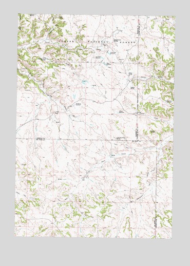
Hamilton Draw, MT USGS Topographic Map
Click on map above to begin viewing in our Map Viewer.

This topographic map contains these locations and features:
Feature Name Type Latitude Longitude GNIS ID View Map
07S44E25DDDA01 WellWellN45.1953°W106.2809°808386View Map
07S44E25DDDA02 SpringSpringN45.1954°W106.2797°808388View Map
07S44E26CDDC01 WellWellN45.1947°W106.3128°808383View Map
07S44E33BBCA01 SpringSpringN45.1919°W106.3598°808374View Map
07S44E34BAAD01 WellWellN45.1936°W106.3309°808379View Map
07S44E34BAAD02 WellWellN45.1936°W106.3309°808380View Map
07S44E35DCCA01 WellWellN45.1808°W106.3086°808325View Map
07S44E35DCCA02 WellWellN45.1808°W106.3086°808326View Map
07S44E36CCDA01 SpringSpringN45.1811°W106.2959°808327View Map
07S44E36DADB01 WellWellN45.1853°W106.2817°808349View Map
07S44E36DADB02 WellWellN45.1853°W106.2817°808350View Map
07S45E19CAAA01 WellWellN45.2153°W106.2706°808455View Map
07S45E31CCBA01 SpringSpringN45.1830°W106.2778°808339View Map
07S45E31DBDA01 SpringSpringN45.1850°W106.2657°808346View Map
07S45E32BDAB01 WellWellN45.1900°W106.2511°808363View Map
07S45E32BDAD01 WellWellN45.1892°W106.2500°808357View Map
07S45E32BDAD02 WellWellN45.1894°W106.2503°808359View Map
07S45E32CADD01 WellWellN45.1839°W106.2500°808341View Map
07S45E32CADD02 WellWellN45.1839°W106.2500°808342View Map
08S44E02AADC01 WellWellN45.1708°W106.2861°808292View Map
08S44E02ADAB01 WellWellN45.1700°W106.2864°808285View Map
08S44E02BACA01 WellWellN45.1717°W106.2978°808300View Map
08S44E02BACA02 WellWellN45.1717°W106.2978°808301View Map
08S44E02BACD01 WellWellN45.1711°W106.2975°808294View Map
08S44E02BACD02 WellWellN45.1705°W106.2973°808290View Map
08S44E02BACD03 WellWellN45.1711°W106.2975°808295View Map
08S44E02BACD04 WellWellN45.1711°W106.2975°808296View Map
08S44E02BBDA01 SpringSpringN45.1718°W106.2999°808303View Map
08S44E02BDAB01 WellWellN45.1700°W106.2970°808286View Map
08S44E03ADDB01 WellWellN45.1675°W106.3064°808270View Map
08S44E03ADDB02 WellWellN45.1680°W106.3067°808274View Map
08S44E03ADDC01 WellWellN45.1672°W106.3061°808269View Map
08S44E03ADDC02 WellWellN45.1669°W106.3059°808267View Map
08S44E03CBBD01 WellWellN45.1630°W106.3217°808247View Map
08S44E03CBBD02 WellWellN45.1630°W106.3217°808248View Map
08S44E05BABB01 WellWellN45.1744°W106.3603°808309View Map
08S44E09DABB01 WellWellN45.1517°W106.3298°808194View Map
08S44E09DABC02 WellWellN45.1514°W106.3295°808192View Map
08S44E09DCAD01 SpringSpringN45.1467°W106.3298°808178View Map
08S44E12ACAA01 SpringSpringN45.1553°W106.2698°808213View Map
08S44E12ACDC01 WellWellN45.1525°W106.2709°808195View Map
08S44E12ACDC02 WellWellN45.1525°W106.2709°808196View Map
08S44E12ADBC02 WellWellN45.1542°W106.2678°808210View Map
08S44E12ADBD01 WellWellN45.1542°W106.2675°808209View Map
08S44E12ADCA01 WellWellN45.1542°W106.2670°808208View Map
08S44E14AACC01 WellWellN45.1417°W106.2889°808152View Map
08S44E14ABAB01 WellWellN45.1442°W106.2917°808168View Map
08S44E14ABAB02 WellWellN45.1442°W106.2917°808169View Map
08S44E14ABAB03 WellWellN45.1442°W106.2917°808170View Map
08S44E15BCCA01 WellWellN45.1389°W106.3223°808134View Map
08S44E15BCDC01 WellWellN45.1386°W106.3214°808132View Map
08S44E15BCDC02 WellWellN45.1386°W106.3214°808133View Map
08S44E18ABAC01 WellWellN45.1433°W106.3725°808164View Map
08S44E18ABDB01 WellWellN45.1428°W106.3728°808160View Map
08S45E06BBAA01 SpringSpringN45.1755°W106.2595°808312View Map
08S45E06BCDA01 WellWellN45.1683°W106.2603°808275View Map
08S45E06BCDB01 WellWellN45.1683°W106.2609°808276View Map
Boyce Meadow SpringSpringN45.2355°W106.2992°780331View Map
Boyce ReservoirReservoirN45.2225°W106.3058°780332View Map
Davidson DrawValleyN45.1747°W106.2617°782099View Map
Fossil SpringSpringN45.2482°W106.3430°783629View Map
Gopher (historical)Populated PlaceN45.2233°W106.3006°1716688View Map
Gopher Post Office (historical)Post OfficeN45.2233°W106.3006°1716689View Map
Gopher School (historical)SchoolN45.2236°W106.3211°1716539View Map
Hamilton DrawValleyN45.2305°W106.3689°784499View Map
Hamilton Draw ReservoirReservoirN45.2246°W106.3527°784500View Map
Handley SpringSpringN45.1850°W106.2650°784513View Map
Holdbrook DrawValleyN45.2367°W106.3531°784930View Map
Hoover ReservoirReservoirN45.1952°W106.2943°784997View Map
Lee Creek ReservoirReservoirN45.2262°W106.3083°786022View Map
Little Bear Creek SpringSpringN45.1810°W106.2958°786229View Map
Loggins SpringSpringN45.2093°W106.2853°786463View Map
Round Cow ReservoirReservoirN45.2284°W106.3026°793879View Map
Stevens Number 1 DamDamN45.2117°W106.3239°797911View Map
Tooley Creek ReservoirReservoirN45.2019°W106.2522°792272View Map
Tooley SpringSpringN45.2173°W106.2870°792275View Map
Woodbury ReservoirReservoirN45.1993°W106.3295°793492View Map

Note: Coordinates in the location and feature list above are referenced to NAD83 datum.


Copyright (C) 2008-2024 Ryan Niemi / Sunset Dynamics ... All Rights Reserved