TopoQuest Logo
Do you find TopoQuest useful?
Help keep TopoQuest running and adding new maps/features by donating!
Bitcoin:  19c7KJd3qBynnjoSw5npx9KScwjBe4ifkT
Litecoin:  LXs6TkuXGGXo1vDsWCkWVdjQX94eUKd6ui
Home View Maps Find Maps Find Places Resources & Links


Hamlet, Arkansas Topographic Map

USGS Map Title: Hamlet, AR
USGS Map MRC: 35092A3
DRG (GeoTIFF) Download: o35092a3.tif


Neighboring USGS Topographic Map Quads:


  Greenbrier, AR  
35092B4
 

  Holland, AR  
35092B3
 

  Enola, AR  
35092B2
 

  Conway, AR  
35092A4
 

  Hamlet, AR  
35092A3
 

  Vilonia, AR  
35092A2
 

  Mayflower, AR  
34092H4
 

  Cato, AR  
34092H3
 

  Olmstead, AR  
34092H2


Map MRC Location:

N36°
W93°
N36°
W92°
H8 H7 H6 H5 H4 H3 H2 H1
G8 G7 G6 G5 G4 G3 G2 G1
F8 F7 F6 F5 F4 F3 F2 F1
E8 E7 E6 E5 E4 E3 E2 E1
D8 D7 D6 D5 D4 D3 D2 D1
C8 C7 C6 C5 C4 C3 C2 C1
B8 B7 B6 B5 B4 B3 B2 B1
A8 A7 A6 A5 A4 A3 A2 A1
N35°
W93°
N35°
W92°

Hamlet, AR USGS 1:24K Topographic Map Preview:
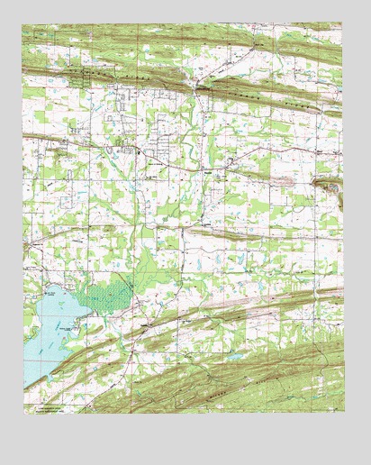
Hamlet, AR USGS Topographic Map
Click on map above to begin viewing in our Map Viewer.

This topographic map contains these locations and features:
Feature Name Type Latitude Longitude GNIS ID View Map
Art Pond LandingLocaleN35.0387°W92.3663°62722View Map
Bass CreekStreamN35.1095°W92.2746°46137View Map
Beaverdam Ford (historical)CrossingN35.0151°W92.3682°62728View Map
Bentley CreekStreamN35.0609°W92.3304°46392View Map
Berry GapGapN35.1181°W92.2838°46409View Map
BerylPopulated PlaceN35.0831°W92.2602°56928View Map
Beryl Baptist ChurchChurchN35.0829°W92.2524°62731View Map
Beryl CemeteryCemeteryN35.0826°W92.2568°62732View Map
Blacks LakeReservoirN35.0493°W92.2902°79401View Map
Blacks Lake DamDamN35.0484°W92.2902°79400View Map
Blacks Lake Number TwoReservoirN35.0406°W92.2826°79403View Map
Blacks Lake Number Two DamDamN35.0418°W92.2835°79402View Map
Brazears Store (historical)LocaleN35.0468°W92.3668°62741View Map
Browns School (historical)SchoolN35.1118°W92.2957°78912View Map
Cadron RidgeRidgeN35.0990°W92.2721°47268View Map
Carter CemeteryCemeteryN35.1106°W92.3032°47493View Map
Church of ChristChurchN35.0798°W92.3210°62762View Map
Crest Lawn Memorial ParkParkN35.0851°W92.3335°48158View Map
Davis School (historical)SchoolN35.0598°W92.3543°62777View Map
Deihl Lake DamDamN35.1034°W92.2518°79392View Map
Duncan School (historical)SchoolN35.0759°W92.3263°76110View Map
Emmanuel Baptist ChurchChurchN35.0551°W92.3718°76876View Map
Fourmile HillSummitN35.0093°W92.2863°57245View Map
Friendship Baptist ChurchChurchN35.0606°W92.3046°76984View Map
Graham Chapel Methodist ChurchChurchN35.0862°W92.3354°77050View Map
HamletPopulated PlaceN35.0781°W92.3052°77110View Map
Haw CreekStreamN35.0643°W92.3077°62823View Map
Jeffries School (historical)SchoolN35.0890°W92.2918°62833View Map
Jones Chapel (historical)ChurchN35.0593°W92.3499°62834View Map
Knap ChurchChurchN35.1070°W92.2688°77414View Map
Liberty CemeteryCemeteryN35.0756°W92.3274°78917View Map
Liberty SchoolSchoolN35.0815°W92.3057°51122View Map
Liberty Volunteer Fire Department Station 1BuildingN35.0789°W92.3150°2116712View Map
Liberty Volunteer Fire Department Station 2BuildingN35.1044°W92.3566°2116713View Map
Little Cypress CreekStreamN35.0609°W92.3274°51259View Map
Little Palarm CreekStreamN35.0640°W92.3163°51303View Map
Metropolitan Emergency Medical Service - LibertyBuildingN35.0789°W92.3148°2119107View Map
Mount Tabor ChurchChurchN35.0309°W92.3388°52421View Map
Muns Store (historical)LocaleN35.0856°W92.3488°62863View Map
New Liberty CemeteryCemeteryN35.0759°W92.2996°52710View Map
New Liberty Church (historical)ChurchN35.0754°W92.3002°62865View Map
Oak Bowery Baptist ChurchChurchN35.0304°W92.3138°77869View Map
Oak Bowery CemeteryCemeteryN35.0298°W92.3140°62868View Map
Oak Bowery School (historical)SchoolN35.0301°W92.3146°76119View Map
Old Liberty Baptist ChurchChurchN35.0762°W92.3257°77907View Map
Palarm Creek LandingLocaleN35.0315°W92.3515°62875View Map
Panther CreekStreamN35.0362°W92.3418°53160View Map
Parks LakeReservoirN35.0475°W92.3066°79398View Map
Parks Lake DamDamN35.0451°W92.3068°79397View Map
Pleasant Grove Church (historical)ChurchN35.0798°W92.3529°62881View Map
Poe's AirportAirportN35.0552°W92.3554°83667View Map
Rocky Ridge School (historical)SchoolN35.0195°W92.3438°62893View Map
Rodans Mill (historical)LocaleN35.1015°W92.3071°62894View Map
Roden Mill GapGapN35.1043°W92.3071°54154View Map
SaltilloPopulated PlaceN35.0276°W92.3265°78288View Map
Saltillo Volunteer Fire DepartmentBuildingN35.0026°W92.3513°2117091View Map
Sunny Gap (historical)Populated PlaceN35.0954°W92.3368°62917View Map
Sunny Gap School (historical)SchoolN35.0948°W92.3365°62918View Map
Township of EagleCivilN35.1060°W92.2814°66528View Map
Township of PalarmCivilN35.0464°W92.2795°66537View Map
Tucker School (historical)SchoolN35.0606°W92.3052°62922View Map
Vilonia Primary SchoolSchoolN35.0807°W92.2891°2039171View Map

Note: Coordinates in the location and feature list above are referenced to NAD83 datum.


Copyright (C) 2008-2025 Ryan Niemi / Sunset Dynamics ... All Rights Reserved