TopoQuest Logo
Do you find TopoQuest useful?
Help keep TopoQuest running and adding new maps/features by donating!
Bitcoin:  19c7KJd3qBynnjoSw5npx9KScwjBe4ifkT
Litecoin:  LXs6TkuXGGXo1vDsWCkWVdjQX94eUKd6ui
Home View Maps Find Maps Find Places Resources & Links


Holland, Arkansas Topographic Map

USGS Map Title: Holland, AR
USGS Map MRC: 35092B3
DRG (GeoTIFF) Download: o35092b3.tif


Neighboring USGS Topographic Map Quads:


  Damascus, AR  
35092C4
 

  Guy, AR  
35092C3
 

  Barney, AR  
35092C2
 

  Greenbrier, AR  
35092B4
 

  Holland, AR  
35092B3
 

  Enola, AR  
35092B2
 

  Conway, AR  
35092A4
 

  Hamlet, AR  
35092A3
 

  Vilonia, AR  
35092A2


Map MRC Location:

N36°
W93°
N36°
W92°
H8 H7 H6 H5 H4 H3 H2 H1
G8 G7 G6 G5 G4 G3 G2 G1
F8 F7 F6 F5 F4 F3 F2 F1
E8 E7 E6 E5 E4 E3 E2 E1
D8 D7 D6 D5 D4 D3 D2 D1
C8 C7 C6 C5 C4 C3 C2 C1
B8 B7 B6 B5 B4 B3 B2 B1
A8 A7 A6 A5 A4 A3 A2 A1
N35°
W93°
N35°
W92°

Holland, AR USGS 1:24K Topographic Map Preview:
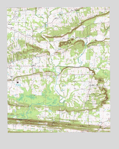
Holland, AR USGS Topographic Map
Click on map above to begin viewing in our Map Viewer.

This topographic map contains these locations and features:
Feature Name Type Latitude Longitude GNIS ID View Map
Acklin GapGapN35.1348°W92.3196°45777View Map
Acklin Gap (historical)Populated PlaceN35.1368°W92.3190°76102View Map
Acklin GraveyardCemeteryN35.1311°W92.3232°2709434View Map
Antioch CemeteryCemeteryN35.2434°W92.3085°62718View Map
Arkavalley AirportAirportN35.1784°W92.3354°2650716View Map
Bailey GapGapN35.2137°W92.3007°46017View Map
Bailey MountainSummitN35.2143°W92.3032°57300View Map
Baileys Chapel (historical)ChurchN35.2073°W92.3024°62723View Map
Bald HillSummitN35.2059°W92.3643°57309View Map
Bass GapGapN35.1309°W92.2829°46138View Map
Bayou MountainSummitN35.1779°W92.2624°57344View Map
Big BranchStreamN35.1862°W92.3207°46513View Map
Black ForkStreamN35.1859°W92.3160°46669View Map
Brushy PondSwampN35.1604°W92.3390°47089View Map
Cadron ValleyValleyN35.2184°W92.2802°47269View Map
Cadron Valley CemeteryCemeteryN35.2195°W92.2910°47270View Map
Cantrell Farms AirportAirportN35.2318°W92.3428°2650786View Map
Caples HollowValleyN35.1637°W92.2721°47461View Map
City of HollandCivilN35.1661°W92.2771°2404711View Map
Clinton MountainRidgeN35.2317°W92.2882°47858View Map
Cold Springs ChurchChurchN35.1331°W92.3193°47910View Map
Cow FordCrossingN35.2220°W92.2563°62773View Map
DeBerry BranchStreamN35.1631°W92.3554°76758View Map
Duck PondSwampN35.1631°W92.3554°48678View Map
Dun HillRidgeN35.1343°W92.3254°76829View Map
Faulkner CountyCivilN35.1470°W92.3320°66852View Map
Goose PondSwampN35.1429°W92.3568°49512View Map
Happy Hollow Baptist ChurchChurchN35.1343°W92.2596°77116View Map
Happy Hollow School (historical)SchoolN35.1343°W92.2593°62813View Map
Happy ValleyValleyN35.2168°W92.2774°62814View Map
Hardin BridgeBridgeN35.2184°W92.2790°62815View Map
Hardin CemeteryCemeteryN35.2120°W92.2721°49850View Map
Hardin HillSummitN35.2137°W92.2729°57881View Map
Harve CreekStreamN35.1520°W92.3065°62819View Map
Henderson CemeteryCemeteryN35.2387°W92.3174°62828View Map
HollandPopulated PlaceN35.1715°W92.2738°77199View Map
Holland Fire DepartmentBuildingN35.1715°W92.2744°2116587View Map
Holland HillSummitN35.1695°W92.2627°57932View Map
Holland Methodist ChurchChurchN35.1718°W92.2732°62830View Map
Hopewell Church (historical)ChurchN35.1551°W92.3715°62831View Map
LinderPopulated PlaceN35.1904°W92.3729°77501View Map
Lost CreekStreamN35.1590°W92.3632°51467View Map
Mabry GapGapN35.1293°W92.2624°51535View Map
McGinty CemeteryCemeteryN35.2292°W92.2813°62851View Map
McGintytownPopulated PlaceN35.2473°W92.2918°77633View Map
McGintytown Assembly of God ChurchChurchN35.2467°W92.2954°76114View Map
Melrose School (historical)SchoolN35.1326°W92.3196°62852View Map
Mill CreekStreamN35.2345°W92.3282°52018View Map
Muddy BayouStreamN35.1904°W92.2863°52527View Map
Needs CreekStreamN35.1876°W92.3240°52592View Map
Needs Creek Baptist ChurchChurchN35.1918°W92.3443°77798View Map
Needs Creek CemeteryCemeteryN35.1923°W92.3446°62864View Map
Negro HillRidgeN35.1523°W92.3674°52599View Map
New Hope School (historical)SchoolN35.1276°W92.2649°76118View Map
Oakland CemeteryCemeteryN35.1565°W92.2796°62870View Map
Oakland Methodist ChurchChurchN35.1568°W92.2782°77889View Map
Oakland School (historical)SchoolN35.1570°W92.2782°76120View Map
Old Salem Church (historical)ChurchN35.2062°W92.3710°62874View Map
Prairie CreekStreamN35.2240°W92.3352°62884View Map
Shady Grove Baptist Church (historical)ChurchN35.2206°W92.3468°62903View Map
Shady Grove CemeteryCemeteryN35.2212°W92.3460°78320View Map
Shady Grove School (historical)SchoolN35.2206°W92.3468°78924View Map
Tarkington CreekStreamN35.2484°W92.3157°62919View Map
Tater HillSummitN35.2176°W92.2954°58729View Map
Township of HardinCivilN35.2295°W92.3542°66531View Map
Township of HarveCivilN35.1593°W92.2788°66532View Map
Township of MatthewsCivilN35.2435°W92.2705°66533View Map

Note: Coordinates in the location and feature list above are referenced to NAD83 datum.


Copyright (C) 2008-2025 Ryan Niemi / Sunset Dynamics ... All Rights Reserved