TopoQuest Logo
Do you find TopoQuest useful?
Help keep TopoQuest running and adding new maps/features by donating!
Bitcoin:  19c7KJd3qBynnjoSw5npx9KScwjBe4ifkT
Litecoin:  LXs6TkuXGGXo1vDsWCkWVdjQX94eUKd6ui
Home View Maps Find Maps Find Places Resources & Links


Mayflower, Arkansas Topographic Map

USGS Map Title: Mayflower, AR
USGS Map MRC: 34092H4
DRG (GeoTIFF) Download: o34092h4.tif


Neighboring USGS Topographic Map Quads:


  Gleason, AR  
35092A5
 

  Conway, AR  
35092A4
 

  Hamlet, AR  
35092A3
 

  Fourche, AR  
34092H5
 

  Mayflower, AR  
34092H4
 

  Cato, AR  
34092H3
 

  Ferndale, AR  
34092G5
 

  Pinnacle Mountain, AR  
34092G4
 

  North Little Rock, AR  
34092G3


Map MRC Location:

N35°
W93°
N35°
W92°
H8 H7 H6 H5 H4 H3 H2 H1
G8 G7 G6 G5 G4 G3 G2 G1
F8 F7 F6 F5 F4 F3 F2 F1
E8 E7 E6 E5 E4 E3 E2 E1
D8 D7 D6 D5 D4 D3 D2 D1
C8 C7 C6 C5 C4 C3 C2 C1
B8 B7 B6 B5 B4 B3 B2 B1
A8 A7 A6 A5 A4 A3 A2 A1
N34°
W93°
N34°
W92°

Mayflower, AR USGS 1:24K Topographic Map Preview:
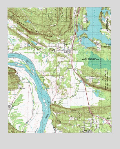
Mayflower, AR USGS Topographic Map
Click on map above to begin viewing in our Map Viewer.

This topographic map contains these locations and features:
Feature Name Type Latitude Longitude GNIS ID View Map
Arkansas Game and Fish EnforcementBuildingN34.9598°W92.3800°2118760View Map
Ballard LandingLocaleN34.9634°W92.4113°57321View Map
Beaver CreekStreamN34.9545°W92.4582°46263View Map
Beaverdam CreekStreamN34.9362°W92.4663°46278View Map
Beaverdam IslandIslandN34.9470°W92.4882°46279View Map
Bell SloughGutN34.9548°W92.4074°46359View Map
Bell Slough State Wildlife Management AreaParkN34.9506°W92.4004°62729View Map
Bibleway ChurchChurchN34.9320°W92.4454°62735View Map
Catorce (historical)Populated PlaceN34.8823°W92.4338°67450View Map
Cedar RidgeRidgeN34.9806°W92.4993°47624View Map
City of MayflowerCivilN34.9682°W92.4227°2405041View Map
Cobb Lake (historical)LakeN34.9765°W92.4021°75604View Map
Conway Lake ChurchChurchN34.9670°W92.3988°62768View Map
Crafton LandingLocaleN34.9745°W92.4077°57597View Map
Davis LakeReservoirN34.9862°W92.4751°75692View Map
Davis Lake DamDamN34.9876°W92.4757°79412View Map
Devils BendBendN34.9454°W92.4735°2784707View Map
Edwards LandingLocaleN34.9645°W92.4118°57703View Map
Flag PondSwampN34.9676°W92.4953°76934View Map
Fletcher BendBendN34.9043°W92.4510°67502View Map
Fletcher Bend Public Use AreaParkN34.9290°W92.4615°49127View Map
Grassy LakeLakeN34.9454°W92.3909°76631View Map
Greens Lake (historical)LakeN34.9898°W92.3927°62810View Map
Haydens Store (historical)LocaleN34.9926°W92.4946°62827View Map
Hi-way LandingLocaleN34.9704°W92.4096°77612View Map
Interchange 135CrossingN34.9706°W92.4190°59003View Map
Interchange 142CrossingN34.8856°W92.3799°59004View Map
Jacks LandingLocaleN34.9895°W92.4040°57975View Map
Jewell LakeReservoirN34.9629°W92.4744°79418View Map
Jewell Lake DamDamN34.9618°W92.4735°79417View Map
Jones HillRidgeN34.8984°W92.3779°67548View Map
Jones Hill Baptist ChurchChurchN34.9618°W92.4760°78915View Map
L D Rogers LakeReservoirN34.9277°W92.4044°79433View Map
L D Rogers Lake DamDamN34.9284°W92.4052°79432View Map
Lake ConwayReservoirN34.9593°W92.4052°75680View Map
Lake Conway DamDamN34.9608°W92.4062°79421View Map
Lake Conway Nursery PondReservoirN34.9901°W92.3835°79411View Map
Lake Conway Nursey Pond DamDamN34.9901°W92.3835°79410View Map
Lake Maumelle Fire DepartmentBuildingN34.9044°W92.4968°2119076View Map
Lake Maumelle Volunteer Fire Department District 8 Station 1BuildingN34.9044°W92.4968°2116686View Map
Maumelle Police DepartmentBuildingN34.8782°W92.3927°2118779View Map
MayflowerPopulated PlaceN34.9570°W92.4274°77619View Map
Mayflower CemeteryCemeteryN34.9598°W92.4396°51761View Map
Mayflower Elementary SchoolSchoolN34.9583°W92.4244°62849View Map
Mayflower High SchoolSchoolN34.9570°W92.4438°62850View Map
Mayflower Middle SchoolSchoolN34.9558°W92.4419°2039169View Map
Mayflower Police DepartmentBuildingN34.9601°W92.4249°2118757View Map
Mayflower Post OfficePost OfficeN34.9591°W92.4250°2781929View Map
Mayflower Volunteer Fire DepartmentBuildingN34.9597°W92.4249°2116774View Map
Methodist Behavioral HospitalHospitalN34.8766°W92.3945°2092864View Map
Monnie SpringsPopulated PlaceN34.9195°W92.4860°52133View Map
Mount PilgrimPopulated PlaceN34.8945°W92.4415°58225View Map
New Zion ChurchChurchN34.8881°W92.3968°52749View Map
Northside ChurchChurchN34.9629°W92.4296°62866View Map
Northwest Assembly ChurchChurchN34.8840°W92.4004°67614View Map
PalarmPopulated PlaceN34.9051°W92.4477°58318View Map
Palarm Public Use AreaParkN34.9026°W92.4493°77942View Map
Paradise LandingLocaleN34.9773°W92.4088°58322View Map
Pierce Creek Public Boat LandingParkN34.9626°W92.3785°62880View Map
Pine Village AirportAirportN34.9831°W92.4445°83771View Map
Pine Village Volunteer Fire DepartmentBuildingN34.9861°W92.4343°2116973View Map
Pooles LandingLocaleN34.9759°W92.4154°58411View Map
Reynolds MountainSummitN34.9759°W92.4718°58483View Map
Roberts Minnow Pond DamDamN34.9901°W92.4068°81167View Map
Roberts PondReservoirN34.9901°W92.4068°81168View Map
Rocky GapGapN34.9901°W92.4954°62892View Map
RolandPopulated PlaceN34.9006°W92.4982°54168View Map
Sport Haven LandingLocaleN34.9712°W92.4038°58669View Map
State of ArkansasCivilN34.8998°W92.4392°68085View Map
Stone LakeReservoirN34.9651°W92.4683°79420View Map
Stone Lake DamDamN34.9634°W92.4652°79419View Map
Township of DanleyCivilN34.9575°W92.3962°66527View Map
Township of Roland (historical)CivilN34.9001°W92.4988°68500View Map
Trinity Grove ChurchChurchN34.8837°W92.4077°55655View Map
Tupelo Gum PondSwampN34.9118°W92.3890°78596View Map
Washam School (historical)SchoolN34.9673°W92.3990°62931View Map
West MarchePopulated PlaceN34.8804°W92.4079°78726View Map
White City ChurchChurchN34.9331°W92.4493°78746View Map

Note: Coordinates in the location and feature list above are referenced to NAD83 datum.


Copyright (C) 2008-2025 Ryan Niemi / Sunset Dynamics ... All Rights Reserved