TopoQuest Logo
Do you find TopoQuest useful?
Help keep TopoQuest running and adding new maps/features by donating!
Bitcoin:  19c7KJd3qBynnjoSw5npx9KScwjBe4ifkT
Litecoin:  LXs6TkuXGGXo1vDsWCkWVdjQX94eUKd6ui
Home View Maps Find Maps Find Places Resources & Links


Hampstead, Maryland Topographic Map

USGS Map Title: Hampstead, MD
USGS Map MRC: 39076E7
DRG (GeoTIFF) Download: o39076e7.tif


Neighboring USGS Topographic Map Quads:


  Manchester, MD  
39076F8
 

  Lineboro, MD  
39076F7
 

  New Freedom, PA  
39076F6
 

  Westminster, MD  
39076E8
 

  Hampstead, MD  
39076E7
 

  Hereford, MD  
39076E6
 

  Finksburg, MD  
39076D8
 

  Reisterstown, MD  
39076D7
 

  Cockeysville, MD  
39076D6


Map MRC Location:

N40°
W77°
N40°
W76°
H8 H7 H6 H5 H4 H3 H2 H1
G8 G7 G6 G5 G4 G3 G2 G1
F8 F7 F6 F5 F4 F3 F2 F1
E8 E7 E6 E5 E4 E3 E2 E1
D8 D7 D6 D5 D4 D3 D2 D1
C8 C7 C6 C5 C4 C3 C2 C1
B8 B7 B6 B5 B4 B3 B2 B1
A8 A7 A6 A5 A4 A3 A2 A1
N39°
W77°
N39°
W76°

Hampstead, MD USGS 1:24K Topographic Map Preview:
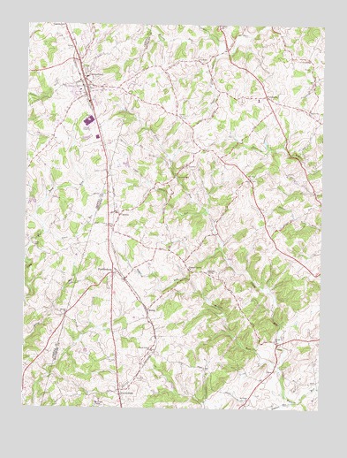
Hampstead, MD USGS Topographic Map
Click on map above to begin viewing in our Map Viewer.

This topographic map contains these locations and features:
Feature Name Type Latitude Longitude GNIS ID View Map
Alma MeadowsPopulated PlaceN39.5865°W76.8622°1695953View Map
Arcadia Volunteer Fire Company Station 43BuildingN39.5633°W76.8367°2087008View Map
Arched Bow ValleyPopulated PlaceN39.6234°W76.8305°1695954View Map
ArmacostPopulated PlaceN39.6134°W76.8039°589652View Map
Aspen RunStreamN39.5570°W76.8672°582944View Map
Berrywood VillagePopulated PlaceN39.5070°W76.8728°1695956View Map
Black and Decker Manufacturing Company DamDamN39.5868°W76.8547°594510View Map
Black and Decker Manufacturing Company ReservoirReservoirN39.5868°W76.8547°594511View Map
Black and Decker Stormwater Pond DamDamN39.5884°W76.8480°594512View Map
Blue Grass ManorPopulated PlaceN39.5665°W76.8597°1695957View Map
BoringPopulated PlaceN39.5318°W76.8228°589789View Map
Boring Post OfficePost OfficeN39.5300°W76.8224°595541View Map
Boring United Methodist ChurchChurchN39.5332°W76.8239°593545View Map
Boring Volunteer Fire Company Station 42BuildingN39.5304°W76.8221°2087009View Map
Brilhart TerracePopulated PlaceN39.6101°W76.8728°1695958View Map
Brookmead FarmsLocaleN39.5107°W76.8650°1695959View Map
Buena Vista EstatesPopulated PlaceN39.6132°W76.8214°593560View Map
Carroll County Fire Department Station 2 Hampstead Volunteer CompanyBuildingN39.6103°W76.8519°2085684View Map
Carrs Store (historical)Populated PlaceN39.5673°W76.7775°593570View Map
Castle OaksPopulated PlaceN39.5895°W76.8644°1695963View Map
CedarbrookPopulated PlaceN39.6054°W76.8319°1695964View Map
Clear ViewPopulated PlaceN39.5959°W76.8411°1695965View Map
Clydesdale AcresPopulated PlaceN39.5226°W76.8647°1695966View Map
Crestview MeadowsPopulated PlaceN39.6145°W76.8389°1695967View Map
Delaware RunStreamN39.5020°W76.7622°584084View Map
District 5CivilN39.5892°W76.7716°1929622View Map
District 8, HampsteadCivilN39.6004°W76.8721°1929692View Map
DoverPopulated PlaceN39.5123°W76.7694°590106View Map
Dover ChurchChurchN39.5223°W76.7689°584143View Map
Emory CemeteryCemeteryN39.5307°W76.8580°1695969View Map
Emory ChurchChurchN39.5304°W76.8572°584303View Map
England EstatesPopulated PlaceN39.6220°W76.8255°1695970View Map
Fenwood HeightsPopulated PlaceN39.5148°W76.8716°1695971View Map
Fifth District Elementary SchoolSchoolN39.6010°W76.7773°593611View Map
Forest ChurchChurchN39.6109°W76.7555°584441View Map
ForestonPopulated PlaceN39.6137°W76.7553°590218View Map
FowblesburgPopulated PlaceN39.5440°W76.8375°590236View Map
Grace United Methodist ChurchChurchN39.5948°W76.8100°584681View Map
Gunpowder Game FarmLocaleN39.6178°W76.7969°2519175View Map
HaletownPopulated PlaceN39.5968°W76.7561°590402View Map
HampsteadPopulated PlaceN39.6048°W76.8500°590408View Map
Hampstead Elementary SchoolSchoolN39.6022°W76.8623°1695974View Map
Hampstead HeightsPopulated PlaceN39.6193°W76.8511°1695975View Map
Hampstead Memorial ParkParkN39.6184°W76.8555°1695976View Map
Hampstead Police DepartmentBuildingN39.6048°W76.8501°2087290View Map
Hampstead Post OfficePost OfficeN39.6085°W76.8526°1695977View Map
Hampstead Town HallBuildingN39.6029°W76.8533°1695978View Map
Hampstead ValleyPopulated PlaceN39.6001°W76.8466°1695979View Map
Hampstead Wastewater Treatment PlantLocaleN39.5976°W76.8333°2503342View Map
Highfield EstatesPopulated PlaceN39.6023°W76.8553°1695980View Map
Hunter GreenPopulated PlaceN39.5970°W76.7650°593671View Map
KempfieldPopulated PlaceN39.6204°W76.8453°1695981View Map
Kingston RidingPopulated PlaceN39.5484°W76.8636°1695982View Map
Lees MillPopulated PlaceN39.5532°W76.8711°590651View Map
Little Piney RunStreamN39.5643°W76.7986°585501View Map
Loblolly FarmLocaleN39.5969°W76.8269°2651778View Map
Loblolly FarmLocaleN39.5967°W76.8228°2519173View Map
Martins Tree FarmLocaleN39.6206°W76.7906°2519176View Map
McGill RunStreamN39.5134°W76.7675°585762View Map
Melanie AcresPopulated PlaceN39.5993°W76.8528°1695985View Map
Montrose ChapelChurchN39.5007°W76.8441°585943View Map
Morning Star Christian SchoolSchoolN39.5850°W76.8424°2132393View Map
Mount Gilead CemeteryCemeteryN39.5158°W76.8391°585997View Map
Mount Zion ChurchChurchN39.5748°W76.7805°586063View Map
Murphy RunStreamN39.6218°W76.7991°586118View Map
North Carroll High SchoolSchoolN39.6102°W76.8613°1695986View Map
Oakdale ManorPopulated PlaceN39.5926°W76.8633°1695988View Map
Peggys RunStreamN39.6159°W76.7930°586464View Map
Piney Branch Golf CourseLocaleN39.5790°W76.8358°593769View Map
Piney Grove ChurchChurchN39.5190°W76.8208°586547View Map
Piney RunStreamN39.5257°W76.7669°586567View Map
Pleasant GrovePopulated PlaceN39.5440°W76.7980°591024View Map
Pleasant Grove Methodist ChurchChurchN39.5451°W76.8058°586588View Map
Pleasant RunPopulated PlaceN39.5382°W76.8094°593773View Map
Roberts FieldPopulated PlaceN39.5993°W76.8400°1695989View Map
Roberts Field Business CenterLocaleN39.5945°W76.8436°1695990View Map
Saint Johns CemeteryCemeteryN39.6073°W76.8486°587034View Map
Saint Johns ChurchChurchN39.5026°W76.7805°587048View Map
Saint Johns United Methodist ChurchChurchN39.6070°W76.8505°1695991View Map
Saint Mark Lutheran ChurchChurchN39.6104°W76.8519°1695992View Map
Saint Pauls Lutheran ChurchChurchN39.5593°W76.8386°593796View Map
Scotts RidgePopulated PlaceN39.6087°W76.8316°1695993View Map
Shiloh Middle SchoolSchoolN39.5991°W76.8613°2132710View Map
Singer HeightsPopulated PlaceN39.5968°W76.8586°1695994View Map
Small CrossingsPopulated PlaceN39.6134°W76.8508°1695995View Map
Southglenn FarmsPopulated PlaceN39.5209°W76.8650°1695997View Map
SouthwoodPopulated PlaceN39.5523°W76.8555°1695998View Map
Spring Garden Elementary SchoolSchoolN39.5930°W76.8405°1695999View Map
SteeplechasePopulated PlaceN39.6198°W76.7747°593815View Map
Town of HampsteadCivilN39.6109°W76.8552°2390228View Map
TrentonPopulated PlaceN39.5790°W76.8078°591428View Map
Trenton MillPopulated PlaceN39.5754°W76.8111°591429View Map
Trenton Mills FarmLocaleN39.5831°W76.8194°2519178View Map
UppercoPopulated PlaceN39.5629°W76.8353°591461View Map
Upperco Post OfficePost OfficeN39.5639°W76.8374°595555View Map
Waterspout RunStreamN39.5032°W76.7575°588078View Map
WGRX-FM (Westminster)TowerN39.6165°W76.8600°598504View Map
WhitehousePopulated PlaceN39.6018°W76.7741°591549View Map
Wolf HillPopulated PlaceN39.5768°W76.8455°1696001View Map
WoodensburgPopulated PlaceN39.5057°W76.8341°591590View Map

Note: Coordinates in the location and feature list above are referenced to NAD83 datum.


Copyright (C) 2008-2024 Ryan Niemi / Sunset Dynamics ... All Rights Reserved