TopoQuest Logo
Do you find TopoQuest useful?
Help keep TopoQuest running and adding new maps/features by donating!
Bitcoin:  19c7KJd3qBynnjoSw5npx9KScwjBe4ifkT
Litecoin:  LXs6TkuXGGXo1vDsWCkWVdjQX94eUKd6ui
Home View Maps Find Maps Find Places Resources & Links


Manchester, Maryland Topographic Map

USGS Map Title: Manchester, MD
USGS Map MRC: 39076F8
DRG (GeoTIFF) Download: o39076f8.tif


Neighboring USGS Topographic Map Quads:


  McSherrystown, PA  
39077G1
 

  Hanover, PA  
39076G8
 

  Seven Valleys, PA  
39076G7
 

  Littlestown, PA  
39077F1
 

  Manchester, MD  
39076F8
 

  Lineboro, MD  
39076F7
 

  New Windsor, MD  
39077E1
 

  Westminster, MD  
39076E8
 

  Hampstead, MD  
39076E7


Map MRC Location:

N40°
W77°
N40°
W76°
H8 H7 H6 H5 H4 H3 H2 H1
G8 G7 G6 G5 G4 G3 G2 G1
F8 F7 F6 F5 F4 F3 F2 F1
E8 E7 E6 E5 E4 E3 E2 E1
D8 D7 D6 D5 D4 D3 D2 D1
C8 C7 C6 C5 C4 C3 C2 C1
B8 B7 B6 B5 B4 B3 B2 B1
A8 A7 A6 A5 A4 A3 A2 A1
N39°
W77°
N39°
W76°

Manchester, MD USGS 1:24K Topographic Map Preview:
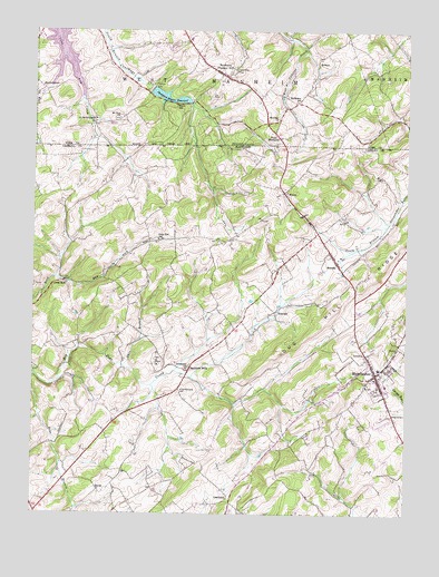
Manchester, MD USGS Topographic Map
Click on map above to begin viewing in our Map Viewer.

This topographic map contains these locations and features:
Feature Name Type Latitude Longitude GNIS ID View Map
Advocates ChoicePopulated PlaceN39.6418°W76.9830°1695461View Map
Allana AcresPopulated PlaceN39.7137°W76.9150°1695411View Map
Bachman MillsPopulated PlaceN39.6626°W76.9469°589674View Map
Bachman Valley EstatesPopulated PlaceN39.6651°W76.9386°1695464View Map
Bamberger FarmsLocaleN39.6870°W76.9516°1695415View Map
BandannaPopulated PlaceN39.7387°W76.9372°1213132View Map
Bethel CemeteryCemeteryN39.6579°W76.8844°1695465View Map
Bethel United Methodist ChurchChurchN39.6582°W76.8841°1695466View Map
BixlerPopulated PlaceN39.6312°W76.9772°589761View Map
Bixler CemeteryCemeteryN39.6648°W76.9578°1695467View Map
Bixler ChurchChurchN39.6648°W76.9580°583259View Map
Bixler Valley EstatesPopulated PlaceN39.6815°W76.9700°1695468View Map
Bixlers United Brethren of Christ Church (historical)ChurchN39.6648°W76.9580°1695469View Map
Brook Hill AcresPopulated PlaceN39.7123°W76.8844°1695471View Map
Cape Hill FarmsPopulated PlaceN39.6365°W76.8836°1695473View Map
Carroll County Fire Department Station 4 Manchester Volunteer Fire DepartmentBuildingN39.6618°W76.8848°2085685View Map
Christmas Tree ParkParkN39.6668°W76.8764°1695474View Map
Country Life EstatesPopulated PlaceN39.6487°W76.8830°1695475View Map
Country TrailsPopulated PlaceN39.6918°W76.9500°1695422View Map
CranberryPopulated PlaceN39.6295°W76.9336°590038View Map
Cranberry Meadow FarmsLocaleN39.6290°W76.9250°1695476View Map
Dayspring EstatesPopulated PlaceN39.6348°W76.9005°1695477View Map
Deep RunPopulated PlaceN39.6851°W76.9897°588641View Map
Deep Run Boy Scout CampLocaleN39.6832°W76.9819°1695424View Map
Deep Run SchoolSchoolN39.6959°W76.9583°584077View Map
District 6, ManchesterCivilN39.6735°W76.8932°1929655View Map
Dug HillPopulated PlaceN39.6801°W76.8919°1695478View Map
Dug Hill RidgeRidgeN39.6784°W76.8984°584179View Map
Dug Hill Rod and Gun ClubLocaleN39.6848°W76.9411°1695425View Map
EbbvalePopulated PlaceN39.6773°W76.9189°590127View Map
Ebbvale EstatesPopulated PlaceN39.6954°W76.9228°1695479View Map
Fridinger EstatesPopulated PlaceN39.6551°W76.9294°1695481View Map
Germans Mill (historical)LocaleN39.6515°W76.9830°1695482View Map
Glasers HillPopulated PlaceN39.6393°W76.8847°1695483View Map
Grace Bible Christian PreschoolSchoolN39.6485°W76.8858°2131889View Map
Grace Bible ChurchChurchN39.6495°W76.8864°1695484View Map
Grand Valley AcresPopulated PlaceN39.7051°W76.9689°1695428View Map
Grand Valley FarmsLocaleN39.7112°W76.9741°1695429View Map
Hanover DamDamN39.7351°W76.9600°1176477View Map
Hanover Watershed Wildlife Management AreaParkN39.7182°W76.9325°1695485View Map
Hash FarmLocaleN39.6762°W76.9483°1695431View Map
Hashawha Environmental CenterParkN39.6473°W76.9903°1695486View Map
Hideaway EstatesPopulated PlaceN39.6837°W76.9678°1695488View Map
HobartPopulated PlaceN39.7429°W76.9044°1203820View Map
Hoffacker SchoolSchoolN39.7320°W76.9119°1177157View Map
Holland HillsPopulated PlaceN39.6662°W76.8933°1695489View Map
Immanuel Lutheran ChurchChurchN39.6612°W76.8830°1695490View Map
Irving College (historical)SchoolN39.6584°W76.8819°1695491View Map
Jerusalem CemeteryCemeteryN39.6626°W76.9478°1695492View Map
Jerusalem ChurchChurchN39.6623°W76.9480°585229View Map
Lake HashawhaReservoirN39.6462°W76.9914°1695487View Map
Long View Nursing HomeBuildingN39.6649°W76.8877°2503448View Map
Lutheran CemeteryCemeteryN39.6629°W76.8768°1695498View Map
Maces SchoolSchoolN39.7307°W76.9525°1180152View Map
ManchesterPopulated PlaceN39.6612°W76.8850°590726View Map
Manchester Baptist ChurchChurchN39.6857°W76.8897°1695499View Map
Manchester Elementary SchoolSchoolN39.6632°W76.8839°1695500View Map
Manchester FarmsLocaleN39.6440°W76.8916°1695501View Map
Manchester Police DepartmentBuildingN39.6622°W76.8843°2087291View Map
Manchester Post OfficePost OfficeN39.6613°W76.8861°1695437View Map
Manchester SpringSpringN39.6607°W76.8844°1696296View Map
Manchester Town OfficeBuildingN39.6620°W76.8841°2503456View Map
Manchester United Brethren in Christ Church (historical)ChurchN39.6582°W76.8841°1695503View Map
Manchester Wastewater Treatment PlantLocaleN39.6578°W76.8798°2503457View Map
Martin SpringSpringN39.6473°W76.9897°1696299View Map
Meadow ViewPopulated PlaceN39.7173°W76.8789°1695505View Map
MelrosePopulated PlaceN39.6898°W76.8978°590787View Map
Mich-Trace EstatesPopulated PlaceN39.7093°W76.9664°1695438View Map
Miller Memorial CemeteryCemeteryN39.6568°W76.9508°585885View Map
Mount Zion ChurchChurchN39.7273°W76.9714°1181907View Map
Mountain View Bible CampLocaleN39.7015°W76.9194°1695442View Map
North Carroll Assembly of God CemeteryCemeteryN39.6480°W76.8760°2712206View Map
North Carroll Christian AcademySchoolN39.6468°W76.8767°2132713View Map
Oakleigh RidgePopulated PlaceN39.6987°W76.9258°1695443View Map
Ohio BranchStreamN39.6632°W76.9700°586291View Map
Park RidgePopulated PlaceN39.6504°W76.8947°1695508View Map
Pine Valley ParkParkN39.6687°W76.8855°1695510View Map
Pineridge FarmsPopulated PlaceN39.7098°W76.9575°1695444View Map
Pleasant AcresPopulated PlaceN39.6670°W76.8955°1695511View Map
Pleasant Hill Volunteer Fire Company Station 52BuildingN39.7369°W76.9339°2100063View Map
Rarjem AcresPopulated PlaceN39.7137°W76.9078°1695446View Map
RaubenstinePopulated PlaceN39.7343°W76.9961°1204464View Map
Reeds VillagePopulated PlaceN39.6520°W76.8964°1695512View Map
Ross Run EstatesPopulated PlaceN39.6432°W76.9280°1695513View Map
Royal HeightsPopulated PlaceN39.6559°W76.8872°1695514View Map
Saint Bartholomew ChurchChurchN39.7262°W76.9794°1185809View Map
Saint Bartholomews CemeteryCemeteryN39.6579°W76.8875°1695516View Map
Saint Bartholomews Roman Catholic ChurchChurchN39.6584°W76.8878°1695515View Map
Saint George ChapelChurchN39.6432°W76.8775°1695517View Map
Sheppard-Meyers DamDamN39.7318°W76.9547°1194340View Map
Sheppard-Meyers ReservoirReservoirN39.7320°W76.9543°1187472View Map
Sherman ChurchChurchN39.7273°W76.9180°1187486View Map
Spring MeadowPopulated PlaceN39.6482°W76.9711°1695518View Map
Sterner Heights EstatesPopulated PlaceN39.7015°W76.8755°1695520View Map
Sunnyside FarmsLocaleN39.6447°W76.9703°2519179View Map
Taylors ChoicePopulated PlaceN39.6943°W76.9161°1695521View Map
Town of ManchesterCivilN39.6584°W76.8880°2391284View Map
Township of West ManheimCivilN39.7458°W76.9431°1217311View Map
Trinity CemeteryCemeteryN39.6612°W76.8822°1695522View Map
Trinity United Church of ChristChurchN39.6618°W76.8836°1695523View Map
Twin FarmsLocaleN39.7170°W76.9928°1695454View Map
Valley ViewPopulated PlaceN39.7048°W76.9216°1695459View Map
Valley Vista NorthPopulated PlaceN39.6945°W76.8766°1695525View Map
WentzPopulated PlaceN39.7084°W76.9164°591511View Map
West Annapolis Volunteer Fire Company 40BuildingN39.6603°W76.8894°2085681View Map
West HillPopulated PlaceN39.6343°W76.8844°1695527View Map
West ManheimPopulated PlaceN39.7226°W76.9178°1204930View Map
West Manheim Township Police DepartmentBuildingN39.7479°W76.9475°2099985View Map
Westchester SquarePopulated PlaceN39.6604°W76.8886°1695528View Map
Westside Memorial ParkParkN39.6618°W76.8914°1695529View Map
Whispering ValleyPopulated PlaceN39.6709°W76.8939°1695530View Map

Note: Coordinates in the location and feature list above are referenced to NAD83 datum.


Copyright (C) 2008-2025 Ryan Niemi / Sunset Dynamics ... All Rights Reserved