TopoQuest Logo
Do you find TopoQuest useful?
Help keep TopoQuest running and adding new maps/features by donating!
Bitcoin:  19c7KJd3qBynnjoSw5npx9KScwjBe4ifkT
Litecoin:  LXs6TkuXGGXo1vDsWCkWVdjQX94eUKd6ui
Home View Maps Find Maps Find Places Resources & Links


Big Bend, Missouri Topographic Map

USGS Map Title: Big Bend, MO
USGS Map MRC: 38092A1
DRG (GeoTIFF) Download: o38092a1.tif


Neighboring USGS Topographic Map Quads:


  Van Cleve, MO  
38092B2
 

  Brinktown, MO  
38092B1
 

  Vienna, MO  
38091B8
 

  Brays, MO  
38092A2
 

  Big Bend, MO  
38092A1
 

  Nagogami Lodge, MO  
38091A8
 

  Hancock, MO  
37092H2
 

  Dixon, MO  
37092H1
 

  Newburg, MO  
37091H8


Map MRC Location:

N39°
W93°
N39°
W92°
H8 H7 H6 H5 H4 H3 H2 H1
G8 G7 G6 G5 G4 G3 G2 G1
F8 F7 F6 F5 F4 F3 F2 F1
E8 E7 E6 E5 E4 E3 E2 E1
D8 D7 D6 D5 D4 D3 D2 D1
C8 C7 C6 C5 C4 C3 C2 C1
B8 B7 B6 B5 B4 B3 B2 B1
A8 A7 A6 A5 A4 A3 A2 A1
N38°
W93°
N38°
W92°

Big Bend, MO USGS 1:24K Topographic Map Preview:
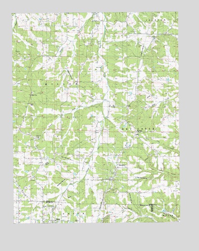
Big Bend, MO USGS Topographic Map
Click on map above to begin viewing in our Map Viewer.

This topographic map contains these locations and features:
Feature Name Type Latitude Longitude GNIS ID View Map
Big BendPopulated PlaceN38.0542°W92.0324°714129View Map
Big V Ranch LakeReservoirN38.0769°W92.0366°765121View Map
Branson School (historical)SchoolN38.0923°W92.0660°744508View Map
Bronson SchoolSchoolN38.0975°W92.0685°714740View Map
Bumpass CemeteryCemeteryN38.1181°W92.0616°715033View Map
Clifty SchoolSchoolN38.0314°W92.0079°715988View Map
Dobbs HollowValleyN38.0012°W92.0013°716936View Map
Dodd CemeteryCemeteryN38.1139°W92.0804°716935View Map
Knoblauch LakeReservoirN38.0070°W92.0124°765324View Map
Knoblauch Lake DamDamN38.0067°W92.0118°765323View Map
Prairie CreekStreamN38.0720°W92.0577°724833View Map
Salem School (historical)SchoolN38.1206°W92.0982°725946View Map
Santee SchoolSchoolN38.0425°W92.1068°726052View Map
ShantytownPopulated PlaceN38.0339°W92.0460°737978View Map
Sherrell Lake DamDamN38.0317°W92.1152°765320View Map
Township of MillerCivilN38.0912°W92.1168°766997View Map
Veasmann Lake DamDamN38.1217°W92.1035°765319View Map
Vogt DamDamN38.0767°W92.0385°765120View Map
Weldon (historical)LocaleN38.0964°W92.0416°744692View Map
Weldon Post OfficePost OfficeN38.0959°W92.0418°1934719View Map
West Fairview SchoolSchoolN38.0375°W92.0713°728550View Map

Note: Coordinates in the location and feature list above are referenced to NAD83 datum.


Copyright (C) 2008-2025 Ryan Niemi / Sunset Dynamics ... All Rights Reserved