TopoQuest Logo
Do you find TopoQuest useful?
Help keep TopoQuest running and adding new maps/features by donating!
Bitcoin:  19c7KJd3qBynnjoSw5npx9KScwjBe4ifkT
Litecoin:  LXs6TkuXGGXo1vDsWCkWVdjQX94eUKd6ui
Home View Maps Find Maps Find Places Resources & Links


Hannagan Meadow, Arizona Topographic Map

USGS Map Title: Hannagan Meadow, AZ
USGS Map MRC: 33109F3
DRG (GeoTIFF) Download: o33109f3.tif


Neighboring USGS Topographic Map Quads:


  Big Lake South, AZ  
33109G4
 

  Buffalo Crossing, AZ  
33109G3
 

  Alpine, AZ  
33109G2
 

  Hoodoo Knoll, AZ  
33109F4
 

  Hannagan Meadow, AZ  
33109F3
 

  Beaverhead, AZ  
33109F2
 

  Baldy Bill Point, AZ  
33109E4
 

  Strayhorse, AZ  
33109E3
 

  Bear Mountain, AZ  
33109E2


Map MRC Location:

N34°
W110°
N34°
W109°
H8 H7 H6 H5 H4 H3 H2 H1
G8 G7 G6 G5 G4 G3 G2 G1
F8 F7 F6 F5 F4 F3 F2 F1
E8 E7 E6 E5 E4 E3 E2 E1
D8 D7 D6 D5 D4 D3 D2 D1
C8 C7 C6 C5 C4 C3 C2 C1
B8 B7 B6 B5 B4 B3 B2 B1
A8 A7 A6 A5 A4 A3 A2 A1
N33°
W110°
N33°
W109°

Hannagan Meadow, AZ USGS 1:24K Topographic Map Preview:
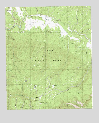
Hannagan Meadow, AZ USGS Topographic Map
Click on map above to begin viewing in our Map Viewer.

This topographic map contains these locations and features:
Feature Name Type Latitude Longitude GNIS ID View Map
Balke CabinLocaleN33.6551°W109.3326°39903View Map
Balke SpringSpringN33.6534°W109.3331°42386View Map
Bardman CanyonValleyN33.7220°W109.2806°25974View Map
Bardman Canyon TankReservoirN33.7391°W109.2654°42542View Map
Bardman TankReservoirN33.7434°W109.2706°42543View Map
Beaver CreekStreamN33.7295°W109.3529°26147View Map
Bill Earl SpringSpringN33.7462°W109.3690°42399View Map
Borrow Pit TankReservoirN33.7476°W109.3534°42536View Map
Caldwell Administrative SiteLocaleN33.7464°W109.3695°25417View Map
Cauldwell Administration SiteLocaleN33.7464°W109.3698°42400View Map
Clay TankReservoirN33.7497°W109.2994°42544View Map
Clear Cut TankReservoirN33.6792°W109.3750°42397View Map
CleavelandPopulated PlaceN33.7217°W109.2812°39944View Map
Clell SpringSpringN33.6409°W109.3112°25419View Map
Clell SpringSpringN33.6409°W109.3104°42322View Map
Cole TankReservoirN33.7124°W109.2777°42535View Map
Corduroy CreekStreamN33.6417°W109.3523°27944View Map
Dart TankReservoirN33.7281°W109.3690°42398View Map
Deep CienegaFlatN33.6603°W109.3459°28361View Map
Deep Cienega TankReservoirN33.6595°W109.3482°42391View Map
Double Cienega CreekStreamN33.6426°W109.3692°28553View Map
East Becker TankReservoirN33.7245°W109.3305°42533View Map
Far TankReservoirN33.6787°W109.3337°42394View Map
Fish TankReservoirN33.6548°W109.3732°39976View Map
Hagen CreekStreamN33.6431°W109.3629°39994View Map
Hagen DrawValleyN33.6431°W109.3626°29678View Map
Hannagan CampgroundLocaleN33.6359°W109.3267°39996View Map
Hannagan Forest Service FacilityLocaleN33.6356°W109.3265°42324View Map
Hannagan MeadowPopulated PlaceN33.6423°W109.3240°29727View Map
Hannagan Meadow Administrative SiteLocaleN33.6331°W109.3259°25416View Map
Hawks Nest CanyonValleyN33.7162°W109.2676°29793View Map
Heifer Branch Beaver CreekStreamN33.7387°W109.3426°29848View Map
Hoot Owl TankReservoirN33.7118°W109.2965°1853547View Map
Horseshoe CienegaSwampN33.6534°W109.3059°30190View Map
Horton CreekStreamN33.7237°W109.3170°30214View Map
Johns CanyonValleyN33.7387°W109.3279°30575View Map
Loop TankReservoirN33.6487°W109.3392°42385View Map
Lost CienegaFlatN33.6523°W109.3340°31295View Map
Lost LakeLakeN33.6731°W109.3695°31303View Map
Lower Hagen SeepSpringN33.6281°W109.3620°42320View Map
Lower Hannagan SpringSpringN33.6464°W109.3115°42323View Map
May Meadow TankReservoirN33.6523°W109.3341°42387View Map
Middle Turkey SpringSpringN33.6645°W109.3465°42392View Map
Middle Turkey SpringSpringN33.6656°W109.3637°25418View Map
Moth SeepSpringN33.6464°W109.3595°42390View Map
P Bar LakeLakeN33.6444°W109.2686°32605View Map
Rocky PrairieAreaN33.7462°W109.3592°42402View Map
Seep TankReservoirN33.7226°W109.2510°42541View Map
Siamese Meadow SeepSpringN33.6323°W109.3576°42321View Map
Spruce TankReservoirN33.6442°W109.2979°40092View Map
SprucedalePopulated PlaceN33.7403°W109.3270°34753View Map
Taylor PondLakeN33.7114°W109.2798°42534View Map
Taylor SinkBasinN33.6981°W109.2690°42539View Map
Taylor Tank and SpringSpringN33.7087°W109.2709°42540View Map
Thomas CreekStreamN33.7084°W109.2531°35266View Map
Thomas Creek WeirDamN33.6778°W109.2626°40112View Map
Triangle SeepsSpringN33.6603°W109.2981°42393View Map
Triple TankReservoirN33.6456°W109.2940°42325View Map
Upper Bear Canyon SeepSpringN33.6734°W109.3642°42396View Map
Upper Hannagan SeepSpringN33.6414°W109.3209°42384View Map
Wallow TankReservoirN33.7000°W109.2882°1851975View Map
West Becker SeepSpringN33.7237°W109.3417°42538View Map
West Becker TankReservoirN33.7226°W109.3415°42537View Map
Willow Corral SPringSpringN33.6692°W109.2990°42388View Map
Willow Corral SpringSpringN33.6667°W109.2992°25420View Map
Willow CreekStreamN33.7317°W109.3017°36227View Map
Willow Creek WeirDamN33.6651°W109.3137°40135View Map
Willow SpringSpringN33.6692°W109.3101°42389View Map

Note: Coordinates in the location and feature list above are referenced to NAD83 datum.


Copyright (C) 2008-2024 Ryan Niemi / Sunset Dynamics ... All Rights Reserved