TopoQuest Logo
Do you find TopoQuest useful?
Help keep TopoQuest running and adding new maps/features by donating!
Bitcoin:  19c7KJd3qBynnjoSw5npx9KScwjBe4ifkT
Litecoin:  LXs6TkuXGGXo1vDsWCkWVdjQX94eUKd6ui
Home View Maps Find Maps Find Places Resources & Links


Bear Mountain, Arizona Topographic Map

USGS Map Title: Bear Mountain, AZ
USGS Map MRC: 33109E2
DRG (GeoTIFF) Download: o33109e2.tif


Neighboring USGS Topographic Map Quads:


  Hannagan Meadow, AZ  
33109F3
 

  Beaverhead, AZ  
33109F2
 

  Maness Peak, AZ  
33109F1
 

  Strayhorse, AZ  
33109E3
 

  Bear Mountain, AZ  
33109E2
 

  Blue, AZ  
33109E1
 

  Rose Peak, AZ  
33109D3
 

  Dutch Blue Creek, AZ  
33109D2
 

  Alma Mesa, AZ  
33109D1


Map MRC Location:

N34°
W110°
N34°
W109°
H8 H7 H6 H5 H4 H3 H2 H1
G8 G7 G6 G5 G4 G3 G2 G1
F8 F7 F6 F5 F4 F3 F2 F1
E8 E7 E6 E5 E4 E3 E2 E1
D8 D7 D6 D5 D4 D3 D2 D1
C8 C7 C6 C5 C4 C3 C2 C1
B8 B7 B6 B5 B4 B3 B2 B1
A8 A7 A6 A5 A4 A3 A2 A1
N33°
W110°
N33°
W109°

Bear Mountain, AZ USGS 1:24K Topographic Map Preview:
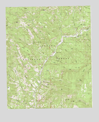
Bear Mountain, AZ USGS Topographic Map
Click on map above to begin viewing in our Map Viewer.

This topographic map contains these locations and features:
Feature Name Type Latitude Longitude GNIS ID View Map
A SpringSpringN33.5589°W109.1334°42687View Map
A SpringSpringN33.5506°W109.1445°25388View Map
Auger PeakSummitN33.5084°W109.1540°25843View Map
Balke CrossingCrossingN33.5867°W109.1440°25389View Map
Barnes CanyonValleyN33.5306°W109.2001°25390View Map
Bear CanyonValleyN33.5070°W109.2079°26059View Map
Bear MountainSummitN33.5334°W109.1445°26096View Map
Bear Mountain LookoutLocaleN33.5334°W109.1434°25391View Map
Bear Mountain LookoutLocaleN33.5337°W109.1442°41996View Map
Bear SpringSpringN33.5230°W109.1684°26109View Map
Blue Camp Administrative SiteLocaleN33.5959°W109.1281°25392View Map
Blue Range Primitive AreaParkN33.5378°W109.1884°41535View Map
Blue Ranger StationLocaleN33.5962°W109.1281°26522View Map
Cedar SpringSpringN33.6089°W109.1379°39941View Map
Cedar Springs CanyonValleyN33.5951°W109.1479°27440View Map
Cole FlatFlatN33.5437°W109.2006°25394View Map
Coleman RanchLocaleN33.5884°W109.1476°25395View Map
CosperLocaleN33.5167°W109.2117°40476View Map
Dead Juniper CanyonValleyN33.5631°W109.1901°25396View Map
Dead Juniper RidgeRidgeN33.5881°W109.2040°25397View Map
Diaper WashValleyN33.5673°W109.1773°25398View Map
Downs CabinLocaleN33.5373°W109.2084°39970View Map
Fishhook CreekStreamN33.5873°W109.1676°29032View Map
Fishhook MesaSummitN33.6242°W109.1590°25399View Map
Foote CreekStreamN33.5898°W109.1484°29095View Map
Foote Creek MesaSummitN33.6192°W109.1401°29096View Map
Grant CreekStreamN33.5709°W109.1781°29499View Map
Grant Creek MesaSummitN33.6073°W109.2009°25400View Map
Grapevine CanyonValleyN33.5303°W109.2309°29507View Map
Grasshopper CanyonValleyN33.5648°W109.1798°25401View Map
Grasshopper SpringSpringN33.5582°W109.1728°25402View Map
Horse CanyonValleyN33.5478°W109.1987°30131View Map
Ice Cream ConePillarN33.5292°W109.1881°25403View Map
K Bar K RanchLocaleN33.5889°W109.1476°40009View Map
KP CreekStreamN33.5284°W109.2015°30694View Map
KP MesaSummitN33.5639°W109.2195°30695View Map
Lanphier CanyonValleyN33.5942°W109.1315°30880View Map
Largo CreekStreamN33.5873°W109.1415°30881View Map
Lee CabinLocaleN33.5687°W109.1784°40015View Map
Mangrum SpringSpringN33.5148°W109.1542°31479View Map
McKittrick CreekStreamN33.5131°W109.2101°31678View Map
Moonshine CanyonValleyN33.5234°W109.2076°31992View Map
Mud SpringSpringN33.6001°W109.2440°32104View Map
Muhly MountainSummitN33.6064°W109.2351°25404View Map
Open Flat CorralLocaleN33.5020°W109.1587°1853716View Map
Owl SpringSpringN33.5112°W109.1611°25405View Map
Panther CreekStreamN33.5762°W109.2076°32659View Map
Raspberry CreekStreamN33.5017°W109.2095°33382View Map
Red Bull CanyonValleyN33.5353°W109.2009°33430View Map
Red SaddlesGapN33.6023°W109.2181°25406View Map
Reynolds RanchLocaleN33.5145°W109.2090°40072View Map
Richardson CabinLocaleN33.5592°W109.1920°40073View Map
Robart RanchLocaleN33.5167°W109.2101°25407View Map
Sawmill CanyonValleyN33.5781°W109.1734°34103View Map
Steeple CreekStreamN33.5573°W109.1920°34818View Map
Steeple MesaSummitN33.5742°W109.2229°34819View Map
Steeple Mesa Seventy-Three TrailTrailN33.5959°W109.2423°40097View Map
Stevens SpringSpringN33.5722°W109.1552°25408View Map
Still CanyonValleyN33.5326°W109.2006°34853View Map
Still SpringSpringN33.5328°W109.1945°40100View Map
Sweetie CanyonValleyN33.5634°W109.1820°34997View Map
Sweetie SpringSpringN33.5474°W109.1584°34998View Map
Telephone RidgeRidgeN33.5489°W109.1354°35182View Map
The BoxBasinN33.5514°W109.1967°35210View Map
Thomas LakeLakeN33.5467°W109.1885°35271View Map
Tolbert CabinLocaleN33.5642°W109.1817°40113View Map
Turtle RockCliffN33.5098°W109.2045°35593View Map
Waynick MountainSummitN33.6203°W109.1962°25409View Map
White Oak SpringSpringN33.6230°W109.2190°36098View Map

Note: Coordinates in the location and feature list above are referenced to NAD83 datum.


Copyright (C) 2008-2025 Ryan Niemi / Sunset Dynamics ... All Rights Reserved