TopoQuest Logo
Do you find TopoQuest useful?
Help keep TopoQuest running and adding new maps/features by donating!
Bitcoin:  19c7KJd3qBynnjoSw5npx9KScwjBe4ifkT
Litecoin:  LXs6TkuXGGXo1vDsWCkWVdjQX94eUKd6ui
Home View Maps Find Maps Find Places Resources & Links


Hanover, Texas Topographic Map

USGS Map Title: Hanover, TX
USGS Map MRC: 30096G7
DRG (GeoTIFF) Download: o30096g7.tif


Neighboring USGS Topographic Map Quads:


  Ben Arnold, TX  
30096H8
 

  Maysfield, TX  
30096H7
 

  Calvert, TX  
30096H6
 

  Cameron, TX  
30096G8
 

  Hanover, TX  
30096G7
 

  Gause, TX  
30096G6
 

  Rockdale East, TX  
30096F8
 

  Milano, TX  
30096F7
 

  Goodwill, TX  
30096F6


Map MRC Location:

N31°
W97°
N31°
W96°
H8 H7 H6 H5 H4 H3 H2 H1
G8 G7 G6 G5 G4 G3 G2 G1
F8 F7 F6 F5 F4 F3 F2 F1
E8 E7 E6 E5 E4 E3 E2 E1
D8 D7 D6 D5 D4 D3 D2 D1
C8 C7 C6 C5 C4 C3 C2 C1
B8 B7 B6 B5 B4 B3 B2 B1
A8 A7 A6 A5 A4 A3 A2 A1
N30°
W97°
N30°
W96°

Hanover, TX USGS 1:24K Topographic Map Preview:
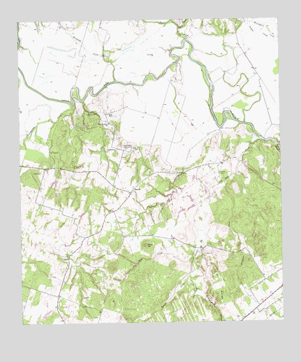
Hanover, TX USGS Topographic Map
Click on map above to begin viewing in our Map Viewer.

This topographic map contains these locations and features:
Feature Name Type Latitude Longitude GNIS ID View Map
Alligator CreekStreamN30.8085°W96.7769°1351010View Map
Armstrong LakeReservoirN30.7552°W96.8653°1865234View Map
Armstrong Lake DamDamN30.7552°W96.8653°1865233View Map
Beaver CreekStreamN30.7752°W96.7925°1351724View Map
Beaver SpringsSpringN30.7624°W96.7958°1998406View Map
Blakely CemeteryCemeteryN30.7819°W96.7831°2071839View Map
Cannonsnap CreekStreamN30.8388°W96.8489°1353762View Map
Copperas BranchStreamN30.8235°W96.7508°1354972View Map
Cox HollowValleyN30.8145°W96.7965°1355254View Map
Coxes Providence ChurchChurchN30.8216°W96.8286°1355267View Map
Coxes Providence Community CemeteryCemeteryN30.8224°W96.8200°1355268View Map
Eland RoughSummitN30.7660°W96.7811°1373613View Map
Hanged Man's CemeteryCemeteryN30.7574°W96.8389°2043297View Map
HanoverPopulated PlaceN30.8038°W96.8216°1379885View Map
Harl CreekStreamN30.8671°W96.7939°1373997View Map
Jess Hood CreekStreamN30.7780°W96.7928°1360239View Map
LibertyPopulated PlaceN30.7771°W96.8522°1380080View Map
Maysfield CreekStreamN30.8499°W96.8280°1362342View Map
Nicholas P Sims LibraryBuildingN30.7513°W96.8519°2014831View Map
Oxsheer-Smith CemeteryCemeteryN30.8363°W96.8425°1364658View Map
Pin Oak CemeteryCemeteryN30.8116°W96.7791°1365249View Map
Pin Oak CreekStreamN30.8252°W96.7578°1365254View Map
Smith RanchLocaleN30.8371°W96.8314°1368500View Map
Tyson CreekStreamN30.8716°W96.7975°1370419View Map
Westbrook - Walker CemeteryCemeteryN30.7571°W96.8733°2043295View Map
White Oak Ridge ChurchChurchN30.8324°W96.8319°1371398View Map
Wilson HillSummitN30.7819°W96.8153°1371717View Map
Yellow Rabbit BranchStreamN30.7641°W96.7919°1372041View Map

Note: Coordinates in the location and feature list above are referenced to NAD83 datum.


Copyright (C) 2008-2025 Ryan Niemi / Sunset Dynamics ... All Rights Reserved