TopoQuest Logo
Do you find TopoQuest useful?
Help keep TopoQuest running and adding new maps/features by donating!
Bitcoin:  19c7KJd3qBynnjoSw5npx9KScwjBe4ifkT
Litecoin:  LXs6TkuXGGXo1vDsWCkWVdjQX94eUKd6ui
Home View Maps Find Maps Find Places Resources & Links


Calvert, Texas Topographic Map

USGS Map Title: Calvert, TX
USGS Map MRC: 30096H6
DRG (GeoTIFF) Download: o30096h6.tif


Neighboring USGS Topographic Map Quads:


  Baileyville, TX  
31096A7
 

  Hammond, TX  
31096A6
 

  Owensville, TX  
31096A5
 

  Maysfield, TX  
30096H7
 

  Calvert, TX  
30096H6
 

  Hearne North, TX  
30096H5
 

  Hanover, TX  
30096G7
 

  Gause, TX  
30096G6
 

  Hearne South, TX  
30096G5


Map MRC Location:

N31°
W97°
N31°
W96°
H8 H7 H6 H5 H4 H3 H2 H1
G8 G7 G6 G5 G4 G3 G2 G1
F8 F7 F6 F5 F4 F3 F2 F1
E8 E7 E6 E5 E4 E3 E2 E1
D8 D7 D6 D5 D4 D3 D2 D1
C8 C7 C6 C5 C4 C3 C2 C1
B8 B7 B6 B5 B4 B3 B2 B1
A8 A7 A6 A5 A4 A3 A2 A1
N30°
W97°
N30°
W96°

Calvert, TX USGS 1:24K Topographic Map Preview:
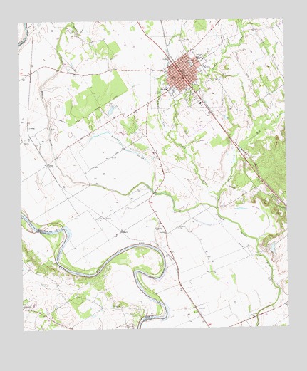
Calvert, TX USGS Topographic Map
Click on map above to begin viewing in our Map Viewer.

This topographic map contains these locations and features:
Feature Name Type Latitude Longitude GNIS ID View Map
A J SidingLocaleN30.9571°W96.7464°1350841View Map
BartonPopulated PlaceN30.9199°W96.7116°1379393View Map
Bethel ChurchChurchN30.9760°W96.6780°1351948View Map
CalvertPopulated PlaceN30.9780°W96.6739°1353586View Map
Calvert Beauty CemeteryCemeteryN30.9705°W96.6714°1353587View Map
Calvert City HallBuildingN30.9793°W96.6732°2753187View Map
Calvert Country ClubLocaleN30.9655°W96.7058°1384539View Map
Calvert DivisionCivilN30.9990°W96.6601°1938592View Map
Calvert High SchoolSchoolN30.9846°W96.6664°2007990View Map
Calvert Historic DistrictLocaleN30.9844°W96.6761°2032188View Map
Calvert JunctionPopulated PlaceN30.9421°W96.7375°1379496View Map
Calvert Police DepartmentBuildingN30.9793°W96.6732°2739251View Map
Calvert Post OfficePost OfficeN30.9782°W96.6748°2731210View Map
Calvert Volunteer Fire DepartmentBuildingN30.9792°W96.6731°2552507View Map
City of CalvertCivilN30.9791°W96.6715°2409965View Map
Foster CemeteryCemeteryN30.9035°W96.7480°1357614View Map
Garret Grove ChurchChurchN30.9719°W96.6778°1357899View Map
GoodlandPopulated PlaceN30.8821°W96.6680°1379844View Map
Hammond HouseBuildingN30.9807°W96.6705°2031089View Map
KCRM-FM (Cameron)TowerN30.8921°W96.7439°1387922View Map
MarvinPopulated PlaceN30.9146°W96.7030°1380148View Map
Mud CreekStreamN30.9235°W96.6583°1363399View Map
New Hope ChurchChurchN30.9841°W96.6794°1363734View Map
Old Providence CemeteryCemeteryN30.8855°W96.7494°1364463View Map
Old Providence ChurchChurchN30.8846°W96.7500°1364464View Map
Peters SloughGutN30.9477°W96.7005°1365111View Map
Port Sullivan (historical)Populated PlaceN30.8835°W96.7033°2034806View Map
Port Sullivan ChurchChurchN30.8835°W96.7058°1365596View Map
Providence CemeteryCemeteryN30.9157°W96.6764°1365813View Map
Providence ChurchChurchN30.9135°W96.6819°1365820View Map
Putz Aero Incorporated Airport (historical)AirportN30.9149°W96.6855°1386331View Map
Saint Lukes CemeteryCemeteryN30.9291°W96.6372°1367232View Map
Saint Lukes ChurchChurchN30.9227°W96.6255°1367235View Map
Saint Paul ChurchChurchN30.9813°W96.6794°1367295View Map
Sandy CreekStreamN30.9288°W96.6566°1367708View Map
Spikner High SchoolSchoolN30.9719°W96.6808°1368901View Map
Sunnyside CemeteryCemeteryN30.9916°W96.6728°1369406View Map
Tidwell CreekStreamN30.9532°W96.6800°1369922View Map
Virginia Field ParkParkN30.9832°W96.6694°1370666View Map
Walnut CreekStreamN30.9994°W96.7247°1370807View Map

Note: Coordinates in the location and feature list above are referenced to NAD83 datum.


Copyright (C) 2008-2025 Ryan Niemi / Sunset Dynamics ... All Rights Reserved