TopoQuest Logo
Do you find TopoQuest useful?
Help keep TopoQuest running and adding new maps/features by donating!
Bitcoin:  19c7KJd3qBynnjoSw5npx9KScwjBe4ifkT
Litecoin:  LXs6TkuXGGXo1vDsWCkWVdjQX94eUKd6ui
Home View Maps Find Maps Find Places Resources & Links


Hanover Academy, Virginia Topographic Map

USGS Map Title: Hanover Academy, VA
USGS Map MRC: 37077G5
DRG (GeoTIFF) Download: o37077g5.tif


Neighboring USGS Topographic Map Quads:


  Beaverdam, VA  
37077H6
 

  Hewlett, VA  
37077H5
 

  Ruther Glen, VA  
37077H4
 

  Montpelier, VA  
37077G6
 

  Hanover Academy, VA  
37077G5
 

  Ashland, VA  
37077G4
 

  Hylas, VA  
37077F6
 

  Glen Allen, VA  
37077F5
 

  Yellow Tavern, VA  
37077F4


Map MRC Location:

N38°
W78°
N38°
W77°
H8 H7 H6 H5 H4 H3 H2 H1
G8 G7 G6 G5 G4 G3 G2 G1
F8 F7 F6 F5 F4 F3 F2 F1
E8 E7 E6 E5 E4 E3 E2 E1
D8 D7 D6 D5 D4 D3 D2 D1
C8 C7 C6 C5 C4 C3 C2 C1
B8 B7 B6 B5 B4 B3 B2 B1
A8 A7 A6 A5 A4 A3 A2 A1
N37°
W78°
N37°
W77°

Hanover Academy, VA USGS 1:24K Topographic Map Preview:
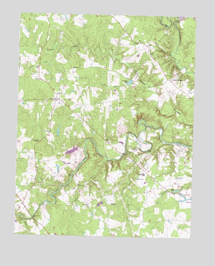
Hanover Academy, VA USGS Topographic Map
Click on map above to begin viewing in our Map Viewer.

This topographic map contains these locations and features:
Feature Name Type Latitude Longitude GNIS ID View Map
Beaver CreekStreamN37.8432°W77.5419°1462926View Map
Beaverdam DistrictCivilN37.8509°W77.5553°1927089View Map
Beech CreekStreamN37.7932°W77.5597°1462998View Map
Blunts BridgeBridgeN37.8032°W77.5083°1463612View Map
Brookmeade Sod FarmLocaleN37.8017°W77.5519°2676067View Map
Campbell DamDamN37.8368°W77.5480°1490014View Map
Campbells PondReservoirN37.8373°W77.5457°1490015View Map
Cedar CreekStreamN37.7785°W77.5922°1464601View Map
Cool Water AirportAirportN37.8581°W77.5451°2675627View Map
Cross Mill (historical)LocaleN37.7768°W77.5089°1748902View Map
Dog BranchStreamN37.7726°W77.5450°1465862View Map
Ebenezer ChurchChurchN37.8301°W77.5964°1466152View Map
Federal ClubLocaleN37.7605°W77.6030°2520160View Map
Fork ChurchChurchN37.8535°W77.5308°1466773View Map
GilmanPopulated PlaceN37.7785°W77.5805°1495590View Map
Gilmans BridgeBridgeN37.7849°W77.5844°1467103View Map
Greenwood ChurchChurchN37.7674°W77.5725°1467522View Map
Ground Squirrel BridgeBridgeN37.7601°W77.6119°1467567View Map
Hanover AcademyLocaleN37.8385°W77.5167°1467715View Map
Hanover Country ClubLocaleN37.7990°W77.5397°1491162View Map
Hanover County Fire / Emergency Medical Services Headquarters / Training CenterBuildingN37.7778°W77.5438°2660563View Map
Holstrum DamDamN37.8651°W77.5347°1489085View Map
Holstrum PondReservoirN37.8651°W77.5347°1489086View Map
Horseshoe BridgeBridgeN37.7996°W77.5314°1468313View Map
Independence ChurchChurchN37.7838°W77.5108°1468454View Map
Janeway Airstrip (historical)AirportN37.8321°W77.5008°1748913View Map
Jones Dam Number OneDamN37.8068°W77.5930°1490025View Map
Jones LakeReservoirN37.8068°W77.5930°1490026View Map
Kings ChapelChurchN37.8038°W77.5594°1469016View Map
Kings PondReservoirN37.7766°W77.5113°1502050View Map
Kings Pond DamDamN37.7771°W77.5097°1490049View Map
Liberty Middle SchoolSchoolN37.7808°W77.5331°2465232View Map
Lucks DamDamN37.7718°W77.5047°1490012View Map
Lucks PondReservoirN37.7714°W77.5053°1490013View Map
Mount Olivet ChurchChurchN37.8376°W77.6086°1471004View Map
Needstan CreekStreamN37.8565°W77.5947°1471362View Map
Negro FootLocaleN37.8265°W77.5978°1471367View Map
OliverPopulated PlaceN37.8582°W77.5328°1477591View Map
Patrick Henry High SchoolSchoolN37.7860°W77.5341°1472103View Map
Pollards DamDamN37.7885°W77.5947°1490010View Map
Pollards PondReservoirN37.7885°W77.5953°1490011View Map
Rocketts Mills (historical)LocaleN37.8438°W77.5419°1748922View Map
ScotchtownPopulated PlaceN37.8443°W77.5867°1496187View Map
Sneeds Mill (historical)LocaleN37.8435°W77.5058°1748923View Map
Stagg CreekStreamN37.8038°W77.5189°1475052View Map
Stanley DamDamN37.8001°W77.5814°1490050View Map
Stone Horse CreekStreamN37.7604°W77.6219°1475177View Map
The Church of TruthChurchN37.8596°W77.5392°1475566View Map
Yates Memorial TabernacleChurchN37.8029°W77.6086°1474326View Map
Young CreekLakeN37.7523°W77.5135°1474365View Map

Note: Coordinates in the location and feature list above are referenced to NAD83 datum.


Copyright (C) 2008-2024 Ryan Niemi / Sunset Dynamics ... All Rights Reserved