TopoQuest Logo
Do you find TopoQuest useful?
Help keep TopoQuest running and adding new maps/features by donating!
Bitcoin:  19c7KJd3qBynnjoSw5npx9KScwjBe4ifkT
Litecoin:  LXs6TkuXGGXo1vDsWCkWVdjQX94eUKd6ui
Home View Maps Find Maps Find Places Resources & Links


Hanson, Kentucky Topographic Map

USGS Map Title: Hanson, KY
USGS Map MRC: 37087D4
DRG (GeoTIFF) Download: o37087d4.tif


Neighboring USGS Topographic Map Quads:


  Sebree, KY  
37087E5
 

  Beech Grove, KY  
37087E4
 

  Calhoun, KY  
37087E3
 

  Slaughters, KY  
37087D5
 

  Hanson, KY  
37087D4
 

  Sacramento, KY  
37087D3
 

  Madisonville West, KY  
37087C5
 

  Madisonville East, KY  
37087C4
 

  Millport, KY  
37087C3


Map MRC Location:

N38°
W88°
N38°
W87°
H8 H7 H6 H5 H4 H3 H2 H1
G8 G7 G6 G5 G4 G3 G2 G1
F8 F7 F6 F5 F4 F3 F2 F1
E8 E7 E6 E5 E4 E3 E2 E1
D8 D7 D6 D5 D4 D3 D2 D1
C8 C7 C6 C5 C4 C3 C2 C1
B8 B7 B6 B5 B4 B3 B2 B1
A8 A7 A6 A5 A4 A3 A2 A1
N37°
W88°
N37°
W87°

Hanson, KY USGS 1:24K Topographic Map Preview:
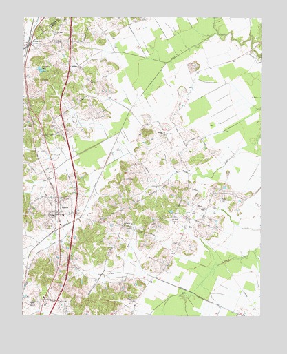
Hanson, KY USGS Topographic Map
Click on map above to begin viewing in our Map Viewer.

This topographic map contains these locations and features:
Feature Name Type Latitude Longitude GNIS ID View Map
City of HansonCivilN37.4173°W87.4788°2403794View Map
Crabtree CemeteryCemeteryN37.4538°W87.4848°490250View Map
Crossroad ChapelChurchN37.4892°W87.4833°490401View Map
East Lawn CemeteryCemeteryN37.4120°W87.4453°491491View Map
Emberry ChurchChurchN37.4514°W87.4264°491756View Map
Gooch CemeteryCemeteryN37.4201°W87.4949°492950View Map
HansonPopulated PlaceN37.4173°W87.4808°493695View Map
Hanson DivisionCivilN37.4646°W87.4317°1937042View Map
Hanson Historical MarkerParkN37.4170°W87.4810°2744437View Map
Hanson Volunteer Fire DepartmentBuildingN37.4171°W87.4822°2636379View Map
Madisonville Fire Department Station 4BuildingN37.3855°W87.4858°2636598View Map
New Hope ChurchChurchN37.4934°W87.4828°499358View Map
Old Salem Holiness ChurchChurchN37.4789°W87.4703°499883View Map
Partisan Rangers Historical MarkerParkN37.4174°W87.4820°2744436View Map
Pritchetts ChapelChurchN37.4198°W87.4042°501355View Map
Providence ChurchChurchN37.4128°W87.4467°501375View Map
Slaughters LakeReservoirN37.4779°W87.4908°503669View Map
VandettaPopulated PlaceN37.4514°W87.4253°505976View Map
West Lawn CemeteryCemeteryN37.4131°W87.4483°506461View Map
Zion ChurchChurchN37.4989°W87.4792°507284View Map

Note: Coordinates in the location and feature list above are referenced to NAD83 datum.


Copyright (C) 2008-2025 Ryan Niemi / Sunset Dynamics ... All Rights Reserved