TopoQuest Logo
Do you find TopoQuest useful?
Help keep TopoQuest running and adding new maps/features by donating!
Bitcoin:  19c7KJd3qBynnjoSw5npx9KScwjBe4ifkT
Litecoin:  LXs6TkuXGGXo1vDsWCkWVdjQX94eUKd6ui
Home View Maps Find Maps Find Places Resources & Links


Beech Grove, Kentucky Topographic Map

USGS Map Title: Beech Grove, KY
USGS Map MRC: 37087E4
DRG (GeoTIFF) Download: o37087e4.tif


Neighboring USGS Topographic Map Quads:


  Robards, KY  
37087F5
 

  Delaware, KY  
37087F4
 

  Curdsville, KY  
37087F3
 

  Sebree, KY  
37087E5
 

  Beech Grove, KY  
37087E4
 

  Calhoun, KY  
37087E3
 

  Slaughters, KY  
37087D5
 

  Hanson, KY  
37087D4
 

  Sacramento, KY  
37087D3


Map MRC Location:

N38°
W88°
N38°
W87°
H8 H7 H6 H5 H4 H3 H2 H1
G8 G7 G6 G5 G4 G3 G2 G1
F8 F7 F6 F5 F4 F3 F2 F1
E8 E7 E6 E5 E4 E3 E2 E1
D8 D7 D6 D5 D4 D3 D2 D1
C8 C7 C6 C5 C4 C3 C2 C1
B8 B7 B6 B5 B4 B3 B2 B1
A8 A7 A6 A5 A4 A3 A2 A1
N37°
W88°
N37°
W87°

Beech Grove, KY USGS 1:24K Topographic Map Preview:
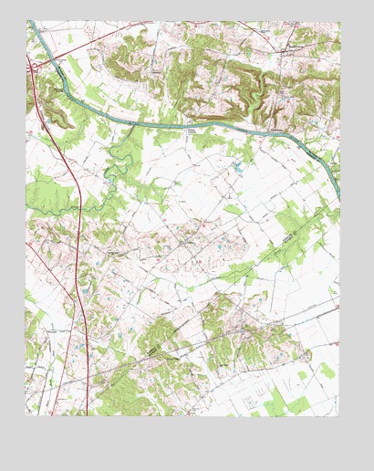
Beech Grove, KY USGS Topographic Map
Click on map above to begin viewing in our Map Viewer.

This topographic map contains these locations and features:
Feature Name Type Latitude Longitude GNIS ID View Map
Beech GrovePopulated PlaceN37.6162°W87.3964°486710View Map
Beech Grove Census Designated PlaceCensusN37.6183°W87.3921°2629572View Map
Beech Grove ChapelChurchN37.6217°W87.4064°486713View Map
Beech Grove Fire DepartmentBuildingN37.6219°W87.3942°2636618View Map
Chelsea (historical)Populated PlaceN37.5237°W87.4271°2743525View Map
Coltharpe HillsRangeN37.5959°W87.4270°2743114View Map
CongletonPopulated PlaceN37.6092°W87.4494°507744View Map
Deer CreekStreamN37.5920°W87.4564°490771View Map
ElmwoodPopulated PlaceN37.5270°W87.4919°507933View Map
James Bethel Gresham Memorial BridgeBridgeN37.6126°W87.4898°493368View Map
LemonPopulated PlaceN37.5812°W87.3783°508443View Map
Mason CreekStreamN37.5901°W87.4081°2743120View Map
Mount Zion CemeteryCemeteryN37.6247°W87.3934°498916View Map
New Salem (historical)Populated PlaceN37.5154°W87.4233°2743537View Map
New Salem ChurchChurchN37.5162°W87.4231°499391View Map
OntonPopulated PlaceN37.5550°W87.4369°499942View Map
Onton CemeteryCemeteryN37.5523°W87.4428°499943View Map
Onton Census Designated PlaceCensusN37.5578°W87.4370°2629659View Map
Onton Fire DepartmentBuildingN37.5553°W87.4384°2637068View Map
Roland LandingCrossingN37.5909°W87.4350°508964View Map
Samuels CemeteryCemeteryN37.5025°W87.4336°502890View Map
Sassafras Grove Methodist ChurchChurchN37.5505°W87.4654°502998View Map
Steamport LandingPopulated PlaceN37.6036°W87.4873°509122View Map
Sugar Camp CreekStreamN37.5150°W87.4886°504638View Map
WrightsburgPopulated PlaceN37.5914°W87.4031°509412View Map
Wrightsburg HillSummitN37.5955°W87.3968°2743137View Map
Yellow CreekStreamN37.5778°W87.3789°507213View Map

Note: Coordinates in the location and feature list above are referenced to NAD83 datum.


Copyright (C) 2008-2024 Ryan Niemi / Sunset Dynamics ... All Rights Reserved