TopoQuest Logo
Do you find TopoQuest useful?
Help keep TopoQuest running and adding new maps/features by donating!
Bitcoin:  19c7KJd3qBynnjoSw5npx9KScwjBe4ifkT
Litecoin:  LXs6TkuXGGXo1vDsWCkWVdjQX94eUKd6ui
Home View Maps Find Maps Find Places Resources & Links


Sebree, Kentucky Topographic Map

USGS Map Title: Sebree, KY
USGS Map MRC: 37087E5
DRG (GeoTIFF) Download: o37087e5.tif


Neighboring USGS Topographic Map Quads:


  Poole, KY  
37087F6
 

  Robards, KY  
37087F5
 

  Delaware, KY  
37087F4
 

  Dixon, KY  
37087E6
 

  Sebree, KY  
37087E5
 

  Beech Grove, KY  
37087E4
 

  Nebo, KY  
37087D6
 

  Slaughters, KY  
37087D5
 

  Hanson, KY  
37087D4


Map MRC Location:

N38°
W88°
N38°
W87°
H8 H7 H6 H5 H4 H3 H2 H1
G8 G7 G6 G5 G4 G3 G2 G1
F8 F7 F6 F5 F4 F3 F2 F1
E8 E7 E6 E5 E4 E3 E2 E1
D8 D7 D6 D5 D4 D3 D2 D1
C8 C7 C6 C5 C4 C3 C2 C1
B8 B7 B6 B5 B4 B3 B2 B1
A8 A7 A6 A5 A4 A3 A2 A1
N37°
W88°
N37°
W87°

Sebree, KY USGS 1:24K Topographic Map Preview:
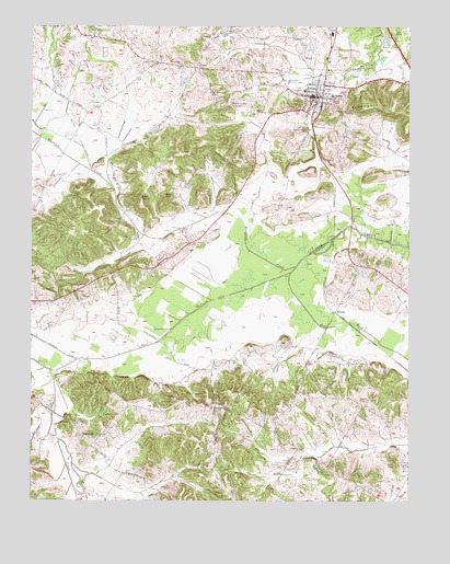
Sebree, KY USGS Topographic Map
Click on map above to begin viewing in our Map Viewer.

This topographic map contains these locations and features:
Feature Name Type Latitude Longitude GNIS ID View Map
Ashley CemeteryCemeteryN37.5897°W87.5408°486099View Map
Bailey DitchCanalN37.5840°W87.5485°2747076View Map
Bald KnobSummitN37.5806°W87.5886°486273View Map
Beal HillSummitN37.5809°W87.5803°486505View Map
BretonPopulated PlaceN37.5506°W87.5236°507580View Map
City of SebreeCivilN37.6040°W87.5187°2405439View Map
Eakins CemeteryCemeteryN37.6203°W87.5342°485812View Map
East Fork Deer CreekStreamN37.5600°W87.5389°491455View Map
GatesvillePopulated PlaceN37.5170°W87.6081°508074View Map
Groves ChapelChurchN37.5273°W87.5133°493441View Map
Havana CreekStreamN37.5267°W87.6170°493874View Map
Knoblick CreekStreamN37.5623°W87.5375°495850View Map
Melton DitchCanalN37.5956°W87.6089°498052View Map
Mount Lebanon ChurchChurchN37.5550°W87.6120°498766View Map
Mount Pleasant ChurchChurchN37.5250°W87.5617°498844View Map
OrtizPopulated PlaceN37.5564°W87.6092°508759View Map
Petersburg ChurchChurchN37.6156°W87.5747°500481View Map
PrattPopulated PlaceN37.6150°W87.5689°508869View Map
Riley Family Home Historical MarkerParkN37.5299°W87.5762°2744254View Map
SebreePopulated PlaceN37.6070°W87.5286°503138View Map
Sebree DivisionCivilN37.5641°W87.5433°1937246View Map
Sebree Fire DepartmentBuildingN37.6061°W87.5316°2636508View Map
Sebree Police DepartmentBuildingN37.6062°W87.5315°2767568View Map
Sebree Springs ParkParkN37.5984°W87.5328°503140View Map
Springdale CemeteryCemeteryN37.5974°W87.5204°504153View Map
Steamport HillSummitN37.6042°W87.5147°504298View Map

Note: Coordinates in the location and feature list above are referenced to NAD83 datum.


Copyright (C) 2008-2025 Ryan Niemi / Sunset Dynamics ... All Rights Reserved