TopoQuest Logo
Do you find TopoQuest useful?
Help keep TopoQuest running and adding new maps/features by donating!
Bitcoin:  19c7KJd3qBynnjoSw5npx9KScwjBe4ifkT
Litecoin:  LXs6TkuXGGXo1vDsWCkWVdjQX94eUKd6ui
Home View Maps Find Maps Find Places Resources & Links


Haralson, Georgia Topographic Map

USGS Map Title: Haralson, GA
USGS Map MRC: 33084B5
DRG (GeoTIFF) Download: o33084b5.tif


Neighboring USGS Topographic Map Quads:


  Sharpsburg, GA  
33084C6
 

  Senoia, GA  
33084C5
 

  Brooks, GA  
33084C4
 

  Luthersville, GA  
33084B6
 

  Haralson, GA  
33084B5
 

  Hollonville, GA  
33084B4
 

  Greenville, GA  
33084A6
 

  Gay, GA  
33084A5
 

  Concord, GA  
33084A4


Map MRC Location:

N34°
W85°
N34°
W84°
H8 H7 H6 H5 H4 H3 H2 H1
G8 G7 G6 G5 G4 G3 G2 G1
F8 F7 F6 F5 F4 F3 F2 F1
E8 E7 E6 E5 E4 E3 E2 E1
D8 D7 D6 D5 D4 D3 D2 D1
C8 C7 C6 C5 C4 C3 C2 C1
B8 B7 B6 B5 B4 B3 B2 B1
A8 A7 A6 A5 A4 A3 A2 A1
N33°
W85°
N33°
W84°

Haralson, GA USGS 1:24K Topographic Map Preview:
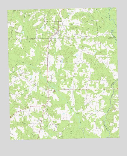
Haralson, GA USGS Topographic Map
Click on map above to begin viewing in our Map Viewer.

This topographic map contains these locations and features:
Feature Name Type Latitude Longitude GNIS ID View Map
AlpsPopulated PlaceN33.1482°W84.6033°354290View Map
AlvatonPopulated PlaceN33.1710°W84.5805°331035View Map
Beaver CreekStreamN33.1632°W84.5641°310983View Map
Beaver Lake Country ClubLocaleN33.1387°W84.5733°354508View Map
Blount-Kirkland LakeReservoirN33.2301°W84.5866°339858View Map
Blount-Kirkland Lake DamDamN33.2301°W84.5866°339857View Map
Blue PondLakeN33.2198°W84.6110°346837View Map
CarmelPopulated PlaceN33.1723°W84.5374°346846View Map
Carr LakeReservoirN33.2052°W84.5466°340052View Map
Carr Lake DamDamN33.2051°W84.5466°340051View Map
Connally CemeteryCemeteryN33.1301°W84.5691°355271View Map
Dead Oak CreekStreamN33.2401°W84.5085°355468View Map
Dennis DamDamN33.2085°W84.5249°340204View Map
Dennis LakeReservoirN33.2072°W84.5254°340205View Map
Double BranchStreamN33.2340°W84.6072°313564View Map
Fagundes FieldAirportN33.2000°W84.5816°351789View Map
Farmdale (historical)Populated PlaceN33.2348°W84.6210°348484View Map
Farmdale School (historical)SchoolN33.2396°W84.6210°348485View Map
First Baptist ChurchChurchN33.1729°W84.5838°346863View Map
Gable BranchStreamN33.2307°W84.5183°314470View Map
Gable Branch AirportAirportN33.2272°W84.5440°351788View Map
Gay DivisionCivilN33.1466°W84.5914°1936281View Map
Gray BranchStreamN33.2293°W84.5055°314797View Map
HaralsonPopulated PlaceN33.2265°W84.5713°356164View Map
Haralson Baptist ChurchChurchN33.2287°W84.5669°348503View Map
Haralson CemeteryCemeteryN33.2248°W84.5741°348504View Map
Haralson CemeteryCemeteryN33.2287°W84.5674°348505View Map
Haralson Methodist ChurchChurchN33.2248°W84.5738°348506View Map
Hutchinson School (historical)SchoolN33.2243°W84.5227°348513View Map
Little White Oak CreekStreamN33.1943°W84.5938°317241View Map
McCrary Elementary SchoolSchoolN33.1436°W84.5896°317880View Map
Meriwether County Volunteer Fire Department Station 4BuildingN33.1713°W84.5803°2604891View Map
Moss DamDamN33.1868°W84.5983°340206View Map
Moss LakeReservoirN33.1853°W84.5993°340207View Map
Mount Carmel ChurchChurchN33.1721°W84.5380°318605View Map
Mount Pilgrim CemeteryCemeteryN33.2354°W84.5830°318803View Map
Mount Pilgrim Lutheran Church (historical)ChurchN33.2354°W84.5827°348549View Map
Mount Sinai ChurchChurchN33.1482°W84.5316°318880View Map
Mount Zion ChurchChurchN33.1493°W84.5360°318997View Map
New Hope ChurchChurchN33.2282°W84.6155°319408View Map
Owens CemeteryCemeteryN33.1337°W84.5885°320128View Map
Piney Grove ChurchChurchN33.2137°W84.5413°320717View Map
Piney Woods CreekStreamN33.2010°W84.6122°320739View Map
Pleasant Hill CemeteryCemeteryN33.2493°W84.6144°348580View Map
Pleasant Hill ChurchChurchN33.2496°W84.6147°320891View Map
Shiloh ChurchChurchN33.1787°W84.5969°322878View Map
Shoals CreekStreamN33.1357°W84.5466°322949View Map
Spencer LakeReservoirN33.2447°W84.5544°339856View Map
Spencer Lake DamDamN33.2451°W84.5533°339855View Map
Swygert LakeReservoirN33.2003°W84.5630°323855View Map
Swygert Lake DamDamN33.1982°W84.5641°340772View Map
Town of HaralsonCivilN33.2285°W84.5690°2406642View Map
White Oak Creek Covered BridgeBridgeN33.1493°W84.5499°346933View Map
Williams LakeReservoirN33.2322°W84.5852°348639View Map
Winky BranchStreamN33.1712°W84.5708°325455View Map
Wolf BranchStreamN33.2098°W84.5924°325479View Map

Note: Coordinates in the location and feature list above are referenced to NAD83 datum.


Copyright (C) 2008-2025 Ryan Niemi / Sunset Dynamics ... All Rights Reserved