TopoQuest Logo
Do you find TopoQuest useful?
Help keep TopoQuest running and adding new maps/features by donating!
Bitcoin:  19c7KJd3qBynnjoSw5npx9KScwjBe4ifkT
Litecoin:  LXs6TkuXGGXo1vDsWCkWVdjQX94eUKd6ui
Home View Maps Find Maps Find Places Resources & Links


Luthersville, Georgia Topographic Map

USGS Map Title: Luthersville, GA
USGS Map MRC: 33084B6
DRG (GeoTIFF) Download: o33084b6.tif


Neighboring USGS Topographic Map Quads:


  Newnan South, GA  
33084C7
 

  Sharpsburg, GA  
33084C6
 

  Senoia, GA  
33084C5
 

  Grantville, GA  
33084B7
 

  Luthersville, GA  
33084B6
 

  Haralson, GA  
33084B5
 

  Odessadale, GA  
33084A7
 

  Greenville, GA  
33084A6
 

  Gay, GA  
33084A5


Map MRC Location:

N34°
W85°
N34°
W84°
H8 H7 H6 H5 H4 H3 H2 H1
G8 G7 G6 G5 G4 G3 G2 G1
F8 F7 F6 F5 F4 F3 F2 F1
E8 E7 E6 E5 E4 E3 E2 E1
D8 D7 D6 D5 D4 D3 D2 D1
C8 C7 C6 C5 C4 C3 C2 C1
B8 B7 B6 B5 B4 B3 B2 B1
A8 A7 A6 A5 A4 A3 A2 A1
N33°
W85°
N33°
W84°

Luthersville, GA USGS 1:24K Topographic Map Preview:
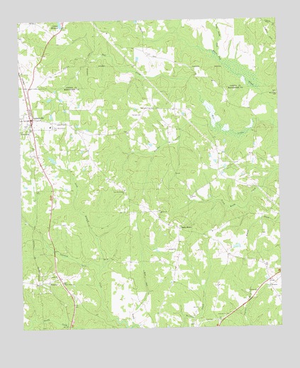
Luthersville, GA USGS Topographic Map
Click on map above to begin viewing in our Map Viewer.

This topographic map contains these locations and features:
Feature Name Type Latitude Longitude GNIS ID View Map
Andrews Mill (historical)LocaleN33.1426°W84.7249°346832View Map
Bear CreekStreamN33.2065°W84.6272°310938View Map
Bethel CemeteryCemeteryN33.1721°W84.6835°346838View Map
Bethel ChurchChurchN33.1723°W84.6827°354605View Map
Binghams Mill (historical)LocaleN33.2468°W84.7288°348446View Map
City of LuthersvilleCivilN33.2096°W84.7443°2404976View Map
Cole CemeteryCemeteryN33.1279°W84.6585°312814View Map
Coleman CreekStreamN33.1265°W84.6960°312827View Map
Coweta County Fire Department Station 15BuildingN33.2477°W84.6267°2604212View Map
Dolliver DamDamN33.1918°W84.7333°340208View Map
Dolliver LakeReservoirN33.1936°W84.7342°340209View Map
Dunlap CemeteryCemeteryN33.1568°W84.6794°313728View Map
Faith ChurchChurchN33.1462°W84.7330°355768View Map
Flying N Estates AirportAirportN33.1771°W84.7482°351831View Map
Hannah CemeteryCemeteryN33.2118°W84.6910°315093View Map
Johnson AirportAirportN33.2259°W84.6659°2770461View Map
Little Sandy CreekStreamN33.2357°W84.6547°317186View Map
Long BranchStreamN33.1487°W84.7124°317312View Map
LuthersvillePopulated PlaceN33.2101°W84.7444°317494View Map
Luthersville Elementary SchoolSchoolN33.2073°W84.7352°346881View Map
Luthersville Fire DepartmentBuildingN33.2101°W84.7441°2603946View Map
Luthersville Police DepartmentBuildingN33.2062°W84.7417°2733539View Map
Massey DamDamN33.1568°W84.6449°340210View Map
Massey LakeReservoirN33.1578°W84.6459°340211View Map
Meriwether County Volunteer Fire Department Station 5BuildingN33.1437°W84.7424°2604547View Map
MidwayPopulated PlaceN33.1457°W84.7319°346897View Map
New Hope ChurchChurchN33.1398°W84.6366°319406View Map
New Mount Bethel ChurchChurchN33.2065°W84.7330°319480View Map
Panther CreekStreamN33.2068°W84.6574°320184View Map
PrimrosePopulated PlaceN33.1435°W84.7419°321144View Map
Primrose United Methodist ChurchChurchN33.1437°W84.7372°346909View Map
Rocky MountPopulated PlaceN33.1654°W84.6733°332901View Map
Rocky Mount Bethel ChurchChurchN33.1812°W84.6997°321849View Map
Sibley MillpondReservoirN33.2488°W84.7298°339860View Map
Sibley Millpond DamDamN33.2473°W84.7283°339859View Map
Strickland Town CemeteryCemeteryN33.2137°W84.6852°323686View Map
Sunnyside ChurchChurchN33.1301°W84.6522°323767View Map
Sunnyside SchoolSchoolN33.1301°W84.6522°346920View Map
Unity Elementary SchoolSchoolN33.2219°W84.7491°2545613View Map
Walker Temple ChurchChurchN33.1437°W84.7297°324786View Map
White Oak CemeteryCemeteryN33.2201°W84.6260°325167View Map
Williams Mill (historical)LocaleN33.2315°W84.7199°348640View Map
WoosterPopulated PlaceN33.1418°W84.6302°333467View Map

Note: Coordinates in the location and feature list above are referenced to NAD83 datum.


Copyright (C) 2008-2025 Ryan Niemi / Sunset Dynamics ... All Rights Reserved