TopoQuest Logo
Do you find TopoQuest useful?
Help keep TopoQuest running and adding new maps/features by donating!
Bitcoin:  19c7KJd3qBynnjoSw5npx9KScwjBe4ifkT
Litecoin:  LXs6TkuXGGXo1vDsWCkWVdjQX94eUKd6ui
Home View Maps Find Maps Find Places Resources & Links


Harkers Island, North Carolina Topographic Map

USGS Map Title: Harkers Island, NC
USGS Map MRC: 34076F5
DRG (GeoTIFF) Download: o34076f5.tif


Neighboring USGS Topographic Map Quads:


  Core Creek, NC  
34076G6
 

  Williston, NC  
34076G5
 

  Davis, NC  
34076G4
 

  Beaufort, NC  
34076F6
 

  Harkers Island, NC  
34076F5
 

  Horsepen Point, NC  
34076F4


  Cape Lookout, NC  
34076E5


Map MRC Location:

N35°
W77°
N35°
W76°
H8 H7 H6 H5 H4 H3 H2 H1
G8 G7 G6 G5 G4 G3 G2 G1
F8 F7 F6 F5 F4 F3 F2 F1
E8 E7 E6 E5 E4 E3 E2 E1
D8 D7 D6 D5 D4 D3 D2 D1
C8 C7 C6 C5 C4 C3 C2 C1
B8 B7 B6 B5 B4 B3 B2 B1
A8 A7 A6 A5 A4 A3 A2 A1
N34°
W77°
N34°
W76°

Harkers Island, NC USGS 1:24K Topographic Map Preview:
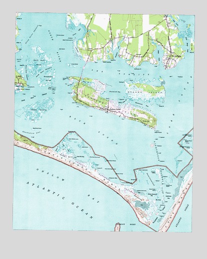
Harkers Island, NC USGS Topographic Map
Click on map above to begin viewing in our Map Viewer.

This topographic map contains these locations and features:
Feature Name Type Latitude Longitude GNIS ID View Map
Back SoundBayN34.6846°W76.5705°980416View Map
Bald HillSummitN34.6677°W76.5866°1018917View Map
Bald Hill BayBayN34.6674°W76.5777°980468View Map
Barden InletChannelN34.6363°W76.5219°1018961View Map
Barden InletChannelN34.6546°W76.5080°1008343View Map
Baregrass IslandIslandN34.6554°W76.5383°980548View Map
Bells IslandIslandN34.7321°W76.5005°1019076View Map
Big Shoal MarshSwampN34.6829°W76.6108°981452View Map
Black Hammock PointBarN34.7343°W76.5844°981531View Map
Blinds HammockIslandN34.6491°W76.5302°981596View Map
Blinds Hammock BayBayN34.6454°W76.5274°981597View Map
Bottle Run PointCapeN34.6818°W76.5844°981755View Map
Brooks CreekBayN34.7107°W76.5833°981973View Map
Browns IslandIslandN34.7054°W76.5338°982039View Map
Bunch of HairIslandN34.6582°W76.5533°982249View Map
Cabs CreekGutN34.6727°W76.5880°982394View Map
Cedar HammockIslandN34.6602°W76.5383°982861View Map
Cockle Marsh IslandIslandN34.6777°W76.5058°983324View Map
Conch Shoal MarshSwampN34.6532°W76.5485°983420View Map
Cow IslandIslandN34.6629°W76.5666°983642View Map
Crab PointCapeN34.7260°W76.5527°983688View Map
Crystal CoastAreaN34.6946°W76.5358°1890543View Map
Davis BayBayN34.7224°W76.6235°983983View Map
Diamond City HillsSummitN34.6457°W76.5374°1019963View Map
Eastmouth BayBayN34.6988°W76.5341°984563View Map
Gaskill LandingLocaleN34.7229°W76.5635°1020404View Map
Gaskill PointCapeN34.7246°W76.5560°985595View Map
GloucesterPopulated PlaceN34.7263°W76.5410°1020455View Map
Gloucester Census Designated PlaceCensusN34.7294°W76.5390°2628629View Map
Gloucester PointCapeN34.7196°W76.5405°985744View Map
Gloucester Post OfficePost OfficeN34.7290°W76.5478°2774021View Map
Goose BayBayN34.7391°W76.5802°985810View Map
Great Marsh CreekChannelN34.7346°W76.5049°986030View Map
Great Marsh IslandIslandN34.6491°W76.5230°986031View Map
Gull IslandIslandN34.7293°W76.5941°986200View Map
Gunning Hammock IslandIslandN34.6729°W76.5002°986261View Map
Hard Working LumpsIslandN34.6604°W76.5583°986386View Map
Harkers IslandPopulated PlaceN34.6952°W76.5594°1020620View Map
Harkers IslandIslandN34.6982°W76.5596°986408View Map
Harkers Island Census Designated PlaceCensusN34.6994°W76.5587°2402566View Map
Harkers Island Fire and Rescue SquadBuildingN34.6934°W76.5494°2638618View Map
Harkers Island Post OfficePost OfficeN34.6966°W76.5662°2774137View Map
Harkers Island SchoolSchoolN34.6941°W76.5516°1002751View Map
Harkers PointCapeN34.7121°W76.5874°986409View Map
Henry Jones CreekBayN34.6993°W76.5471°986629View Map
High HillSummitN34.6771°W76.6180°1020733View Map
Horse IslandIslandN34.6666°W76.5105°987099View Map
Horse MarshSwampN34.7196°W76.5854°987109View Map
Horse PointCapeN34.6607°W76.5655°987115View Map
Island Road Baptist ChurchChurchN34.7447°W76.5595°2506166View Map
Jacks IslandIslandN34.6735°W76.5774°987482View Map
Janes CreekStreamN34.7129°W76.5780°987524View Map
Johnsons BayBayN34.6552°W76.5555°987694View Map
L R Rose Marina and BoatworksHarborN34.6959°W76.5511°2506047View Map
Lenoxville PointCapeN34.7077°W76.6160°988354View Map
Lighthouse BayBayN34.6474°W76.5155°988474View Map
Lighthouse ChannelChannelN34.6641°W76.5230°988476View Map
Little Deep Marsh IslandIslandN34.6793°W76.5002°988622View Map
Lovis ShoreIslandN34.7293°W76.5819°989075View Map
MarshallbergPopulated PlaceN34.7279°W76.5158°989384View Map
Marshallberg Census Designated PlaceCensusN34.7266°W76.5152°2628643View Map
Marshallberg Post OfficePost OfficeN34.7247°W76.5179°2774073View Map
Marshallberg Volunteer Fire DepartmentBuildingN34.7282°W76.5153°2638823View Map
Middle MarshesSwampN34.6938°W76.6080°989785View Map
Morgan IslandIslandN34.6602°W76.5246°990232View Map
Newby CreekStreamN34.7460°W76.6230°991120View Map
North RiverStreamN34.6993°W76.5908°1014024View Map
North River ChannelChannelN34.7021°W76.6085°991265View Map
North River MarshSwampN34.7221°W76.6049°991266View Map
North River ThorofareChannelN34.7174°W76.6049°991267View Map
Oak HammockIslandN34.7124°W76.5683°991416View Map
Porters IslandIslandN34.7357°W76.5877°992727View Map
Refuge Fellowship ChurchChurchN34.7025°W76.5713°2505627View Map
Rush PointCapeN34.7035°W76.5846°993814View Map
Sam Winsors LumpIslandN34.6771°W76.5871°1002797View Map
Sam Winter LumpIslandN34.6777°W76.5866°994205View Map
Sandy PointCapeN34.6982°W76.5241°994298View Map
Shackleford BanksBarN34.6649°W76.5877°994523View Map
Shackleford SlueChannelN34.6793°W76.6071°994525View Map
Sheep IslandIslandN34.6542°W76.5258°994613View Map
Sheep Island SlueChannelN34.6552°W76.5294°994615View Map
Sheephead MarshSwampN34.7127°W76.6008°994623View Map
Shell PointCapeN34.6835°W76.5260°994642View Map
Shep ShoalBarN34.7068°W76.5983°994651View Map
Shooting HammockIslandN34.6677°W76.5716°994762View Map
Simons IslandIslandN34.7374°W76.5960°994848View Map
Sleepy CreekStreamN34.7213°W76.5230°994910View Map
Steep PointCapeN34.7196°W76.6180°995456View Map
Steep Point ChannelChannelN34.7152°W76.6177°995458View Map
Steep Point ChannelChannelN34.7388°W76.6138°995459View Map
StraitsPopulated PlaceN34.7291°W76.5710°995603View Map
Straits HavenPopulated PlaceN34.7302°W76.5785°1002755View Map
Straits United Methodist ChurchChurchN34.7369°W76.5529°2506275View Map
The Black CatPopulated PlaceN34.7129°W76.6244°1022919View Map
The DitchChannelN34.6441°W76.5249°995969View Map
The StraitsChannelN34.7160°W76.5546°996013View Map
Township of Harkers IslandCivilN34.6307°W76.5580°1026502View Map
Township of MarshallbergCivilN34.7306°W76.5092°1026504View Map
TuskPopulated PlaceN34.7443°W76.5185°1023019View Map
Tusk CreekStreamN34.7443°W76.5102°996372View Map
Wading PointCapeN34.7107°W76.5480°996666View Map
Westmouth BayBayN34.7041°W76.5546°997073View Map
Whale CreekBayN34.6721°W76.5938°997094View Map
White PointCapeN34.7007°W76.5519°997199View Map
White Shoal MarshSwampN34.6665°W76.5606°997216View Map
Whitehurst CreekBayN34.7296°W76.5535°997227View Map
Whitehurst IslandIslandN34.6532°W76.5177°997232View Map
Willow PondLakeN34.6888°W76.5294°997421View Map

Note: Coordinates in the location and feature list above are referenced to NAD83 datum.


Copyright (C) 2008-2024 Ryan Niemi / Sunset Dynamics ... All Rights Reserved