TopoQuest Logo
Do you find TopoQuest useful?
Help keep TopoQuest running and adding new maps/features by donating!
Bitcoin:  19c7KJd3qBynnjoSw5npx9KScwjBe4ifkT
Litecoin:  LXs6TkuXGGXo1vDsWCkWVdjQX94eUKd6ui
Home View Maps Find Maps Find Places Resources & Links


Williston, North Carolina Topographic Map

USGS Map Title: Williston, NC
USGS Map MRC: 34076G5
DRG (GeoTIFF) Download: o34076g5.tif


Neighboring USGS Topographic Map Quads:


  Merrimon, NC  
34076H6
 

  South River, NC  
34076H5
 

  Long Bay, NC  
34076H4
 

  Core Creek, NC  
34076G6
 

  Williston, NC  
34076G5
 

  Davis, NC  
34076G4
 

  Beaufort, NC  
34076F6
 

  Harkers Island, NC  
34076F5
 

  Horsepen Point, NC  
34076F4


Map MRC Location:

N35°
W77°
N35°
W76°
H8 H7 H6 H5 H4 H3 H2 H1
G8 G7 G6 G5 G4 G3 G2 G1
F8 F7 F6 F5 F4 F3 F2 F1
E8 E7 E6 E5 E4 E3 E2 E1
D8 D7 D6 D5 D4 D3 D2 D1
C8 C7 C6 C5 C4 C3 C2 C1
B8 B7 B6 B5 B4 B3 B2 B1
A8 A7 A6 A5 A4 A3 A2 A1
N34°
W77°
N34°
W76°

Williston, NC USGS 1:24K Topographic Map Preview:
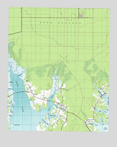
Williston, NC USGS Topographic Map
Click on map above to begin viewing in our Map Viewer.

This topographic map contains these locations and features:
Feature Name Type Latitude Longitude GNIS ID View Map
BettiePopulated PlaceN34.7913°W76.5960°981246View Map
Bettie ChurchChurchN34.7904°W76.5955°1002784View Map
Carteret CountyCivilN34.8613°W76.5357°1026337View Map
Crabbing CreekStreamN34.8002°W76.6202°1010547View Map
Deep CreekStreamN34.8060°W76.6133°984054View Map
Fulcher CreekBayN34.7638°W76.6205°985483View Map
Gillikin CreekStreamN34.7766°W76.5660°985701View Map
Jump RunBayN34.7602°W76.5060°987813View Map
Lynch CreekStreamN34.7921°W76.6191°1013270View Map
Marsh Hen PointCapeN34.7557°W76.6149°989368View Map
Middens CreekBayN34.7579°W76.5144°989761View Map
North Leopard CreekStreamN34.7682°W76.5733°991243View Map
Open GroundsPlainN34.8707°W76.5060°991668View Map
OtwayPopulated PlaceN34.7757°W76.5580°991721View Map
Otway Free Will Baptist ChurchChurchN34.7807°W76.5676°2506210View Map
Otway Volunteer Fire and Rescue DepartmentBuildingN34.7761°W76.5572°2638142View Map
River Road Estate Mobile Home ParkPopulated PlaceN34.7926°W76.5979°2505563View Map
SmyrnaPopulated PlaceN34.7593°W76.5274°995022View Map
Smyrna Elementary SchoolSchoolN34.7579°W76.5287°1002753View Map
Smyrna Post OfficePost OfficeN34.7677°W76.5184°2773851View Map
South Leopard CreekBayN34.7585°W76.5766°995173View Map
Thomas CreekStreamN34.7757°W76.6172°996036View Map
Thomas MarshSwampN34.7714°W76.6204°996041View Map
Township of StraitsCivilN34.7925°W76.5712°1026512View Map
Wade CreekBayN34.7713°W76.5060°996657View Map
Ward CreekStreamN34.7657°W76.5830°996776View Map
WillistonPopulated PlaceN34.7893°W76.5052°1023266View Map
Williston CreekStreamN34.7860°W76.5049°1027482View Map
Woodville ChurchChurchN34.7874°W76.5930°997620View Map
Yucca VillagePopulated PlaceN34.7679°W76.5574°1002756View Map

Note: Coordinates in the location and feature list above are referenced to NAD83 datum.


Copyright (C) 2008-2024 Ryan Niemi / Sunset Dynamics ... All Rights Reserved