TopoQuest Logo
Do you find TopoQuest useful?
Help keep TopoQuest running and adding new maps/features by donating!
Bitcoin:  19c7KJd3qBynnjoSw5npx9KScwjBe4ifkT
Litecoin:  LXs6TkuXGGXo1vDsWCkWVdjQX94eUKd6ui
Home View Maps Find Maps Find Places Resources & Links


Harris, Kansas Topographic Map

USGS Map Title: Harris, KS
USGS Map MRC: 38095C4
DRG (GeoTIFF) Download: o38095c4.tif


Neighboring USGS Topographic Map Quads:


  Waverly, KS  
38095D5
 

  Williamsburg, KS  
38095D4
 

  Richmond, KS  
38095D3
 

  Waverly SE, KS  
38095C5
 

  Harris, KS  
38095C4
 

  Garnett West, KS  
38095C3
 

  Aliceville, KS  
38095B5
 

  Westphalia, KS  
38095B4
 

  Welda, KS  
38095B3


Map MRC Location:

N39°
W96°
N39°
W95°
H8 H7 H6 H5 H4 H3 H2 H1
G8 G7 G6 G5 G4 G3 G2 G1
F8 F7 F6 F5 F4 F3 F2 F1
E8 E7 E6 E5 E4 E3 E2 E1
D8 D7 D6 D5 D4 D3 D2 D1
C8 C7 C6 C5 C4 C3 C2 C1
B8 B7 B6 B5 B4 B3 B2 B1
A8 A7 A6 A5 A4 A3 A2 A1
N38°
W96°
N38°
W95°

Harris, KS USGS 1:24K Topographic Map Preview:
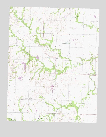
Harris, KS USGS Topographic Map
Click on map above to begin viewing in our Map Viewer.

This topographic map contains these locations and features:
Feature Name Type Latitude Longitude GNIS ID View Map
Andrews LakeReservoirN38.3364°W95.4189°477486View Map
Baird CemeteryCemeteryN38.3178°W95.4891°477488View Map
Beachner Grain Elevator Number 22LocaleN38.3190°W95.4371°2695328View Map
Bethel CemeteryCemeteryN38.2733°W95.4797°477480View Map
Cedar Creek ChurchChurchN38.2742°W95.4703°477482View Map
Centerview SchoolSchoolN38.2739°W95.4714°477481View Map
CentralPopulated PlaceN38.2722°W95.3836°480400View Map
Central (historical)LocaleN38.2736°W95.3878°481846View Map
Central City CemeteryCemeteryN38.2709°W95.3916°477483View Map
Cresco (historical)LocaleN38.3034°W95.4344°482389View Map
Elm CreekStreamN38.3200°W95.3833°477489View Map
Graham Farms AirportAirportN38.3021°W95.4404°481390View Map
HarrisPopulated PlaceN38.3195°W95.4364°477484View Map
Harris Census Designated PlaceCensusN38.3206°W95.4450°2629159View Map
Harris Rural Fire DepartmentBuildingN38.3194°W95.4391°2695495View Map
Kenoma CreekStreamN38.3128°W95.4128°477580View Map
Miller AirportAirportN38.2778°W95.4433°481389View Map
Mineral Point (historical)LocaleN38.3028°W95.4891°482096View Map
Patton CemeteryCemeteryN38.2961°W95.4985°477487View Map
Rochester (historical)LocaleN38.3536°W95.3791°482436View Map
Rocky RunStreamN38.3739°W95.4969°477571View Map
Snake LakeReservoirN38.3212°W95.4450°477485View Map
Thomas CreekStreamN38.2667°W95.4022°477479View Map
Township of ReederCivilN38.3248°W95.4340°477581View Map

Note: Coordinates in the location and feature list above are referenced to NAD83 datum.


Copyright (C) 2008-2025 Ryan Niemi / Sunset Dynamics ... All Rights Reserved