TopoQuest Logo
Do you find TopoQuest useful?
Help keep TopoQuest running and adding new maps/features by donating!
Bitcoin:  19c7KJd3qBynnjoSw5npx9KScwjBe4ifkT
Litecoin:  LXs6TkuXGGXo1vDsWCkWVdjQX94eUKd6ui
Home View Maps Find Maps Find Places Resources & Links


Garnett West, Kansas Topographic Map

USGS Map Title: Garnett West, KS
USGS Map MRC: 38095C3
DRG (GeoTIFF) Download: o38095c3.tif


Neighboring USGS Topographic Map Quads:


  Williamsburg, KS  
38095D4
 

  Richmond, KS  
38095D3
 

  Garnett NW, KS  
38095D2
 

  Harris, KS  
38095C4
 

  Garnett West, KS  
38095C3
 

  Garnett East, KS  
38095C2
 

  Westphalia, KS  
38095B4
 

  Welda, KS  
38095B3
 

  Bush City, KS  
38095B2


Map MRC Location:

N39°
W96°
N39°
W95°
H8 H7 H6 H5 H4 H3 H2 H1
G8 G7 G6 G5 G4 G3 G2 G1
F8 F7 F6 F5 F4 F3 F2 F1
E8 E7 E6 E5 E4 E3 E2 E1
D8 D7 D6 D5 D4 D3 D2 D1
C8 C7 C6 C5 C4 C3 C2 C1
B8 B7 B6 B5 B4 B3 B2 B1
A8 A7 A6 A5 A4 A3 A2 A1
N38°
W96°
N38°
W95°

Garnett West, KS USGS 1:24K Topographic Map Preview:
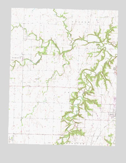
Garnett West, KS USGS Topographic Map
Click on map above to begin viewing in our Map Viewer.

This topographic map contains these locations and features:
Feature Name Type Latitude Longitude GNIS ID View Map
Amish CemeteryCemeteryN38.2620°W95.3505°477491View Map
Anderson County Fire DepartmentBuildingN38.2783°W95.2582°2111101View Map
Anderson County HospitalHospitalN38.2799°W95.2503°2499113View Map
Anderson County JailBuildingN38.2783°W95.2566°2504300View Map
Anderson County Junior / Senior High SchoolSchoolN38.2871°W95.2596°2437493View Map
Baptist CemeteryCemeteryN38.2590°W95.3138°477490View Map
Cedar CreekStreamN38.3339°W95.2580°477649View Map
Church of ChristChurchN38.2744°W95.2580°2690026View Map
Fish CreekStreamN38.3422°W95.3028°477492View Map
GlenlockPopulated PlaceN38.3100°W95.3419°484826View Map
Iantha CreekStreamN38.3397°W95.3355°477574View Map
Kingdom Hall of Jehovah's WitnessesChurchN38.2772°W95.2580°2688723View Map
New Life Baptist ChurchChurchN38.2776°W95.2595°2690030View Map
Pleasantview CemeteryCemeteryN38.3037°W95.3508°477650View Map
Sac CreekStreamN38.3422°W95.3028°477583View Map
Township of JacksonCivilN38.3016°W95.3059°477667View Map
Township of PutnamCivilN38.3676°W95.2642°477589View Map
Trinity Lutheran ChurchChurchN38.2879°W95.2514°2690034View Map
Valley R Agricultural - Service Grain Elevator Number 1LocaleN38.2596°W95.3159°2695217View Map
West Scipio CemeteryCemeteryN38.3686°W95.2664°477651View Map

Note: Coordinates in the location and feature list above are referenced to NAD83 datum.


Copyright (C) 2008-2024 Ryan Niemi / Sunset Dynamics ... All Rights Reserved