TopoQuest Logo
Do you find TopoQuest useful?
Help keep TopoQuest running and adding new maps/features by donating!
Bitcoin:  19c7KJd3qBynnjoSw5npx9KScwjBe4ifkT
Litecoin:  LXs6TkuXGGXo1vDsWCkWVdjQX94eUKd6ui
Home View Maps Find Maps Find Places Resources & Links


Harrison, Wisconsin Topographic Map

USGS Map Title: Harrison, WI
USGS Map MRC: 45089D5
DRG (GeoTIFF) Download: o45089d5.tif


Neighboring USGS Topographic Map Quads:


  Heafford Junction, WI  
45089E6
 

  Woodboro, WI  
45089E5
 

  Lake Julia, WI  
45089E4
 

  Tomahawk, WI  
45089D6
 

  Harrison, WI  
45089D5
 

  Parrish, WI  
45089D4
 

  Irma, WI  
45089C6
 

  Bloomville, WI  
45089C5
 

  Gleason, WI  
45089C4


Map MRC Location:

N46°
W90°
N46°
W89°
H8 H7 H6 H5 H4 H3 H2 H1
G8 G7 G6 G5 G4 G3 G2 G1
F8 F7 F6 F5 F4 F3 F2 F1
E8 E7 E6 E5 E4 E3 E2 E1
D8 D7 D6 D5 D4 D3 D2 D1
C8 C7 C6 C5 C4 C3 C2 C1
B8 B7 B6 B5 B4 B3 B2 B1
A8 A7 A6 A5 A4 A3 A2 A1
N45°
W90°
N45°
W89°

Harrison, WI USGS 1:24K Topographic Map Preview:
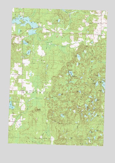
Harrison, WI USGS Topographic Map
Click on map above to begin viewing in our Map Viewer.

This topographic map contains these locations and features:
Feature Name Type Latitude Longitude GNIS ID View Map
2 ReservoirReservoirN45.4500°W89.5768°1793335View Map
Ament LakeLakeN45.4173°W89.5118°1560820View Map
Bass LakeLakeN45.4681°W89.6070°1561244View Map
Bear LakeLakeN45.3878°W89.5180°1561384View Map
Beaver LakeLakeN45.4034°W89.5114°1561468View Map
Big Pine CreekStreamN45.4833°W89.5882°1561753View Map
Bruce LakeLakeN45.4114°W89.5244°1562281View Map
Bughouse LakeLakeN45.4260°W89.5028°1562379View Map
Camp LakeLakeN45.3891°W89.5107°1562622View Map
Clover Belt SchoolSchoolN45.4377°W89.6082°1563203View Map
Clover Belt School (historical)SchoolN45.4383°W89.6090°1964290View Map
Crane Foot LakeLakeN45.4019°W89.5550°1563505View Map
Ebert LakeLakeN45.3815°W89.5441°1564419View Map
Gerbick LakeLakeN45.4593°W89.6020°1565474View Map
Ghost LakeLakeN45.4348°W89.5141°1565500View Map
Green Meadow CreekStreamN45.4816°W89.5968°1565824View Map
HarrisonPopulated PlaceN45.4775°W89.5068°1566089View Map
Harrison HillsRangeN45.4208°W89.5076°1566093View Map
High LakeLakeN45.4245°W89.5331°1566380View Map
Jackknife LakeLakeN45.4404°W89.5085°1567060View Map
Kordick LakeLakeN45.4046°W89.5200°1567617View Map
Lloyd Hilgendorf G-9001 DamDamN45.4500°W89.5768°1793334View Map
Lost LakeLakeN45.4213°W89.5596°1568661View Map
Miller LakeLakeN45.4567°W89.5362°1569515View Map
North Branch Pine CreekStreamN45.4977°W89.5235°1570392View Map
Otter LakeLakeN45.4413°W89.5454°1570909View Map
Otter Lake Recreation AreaParkN45.4377°W89.5435°1570916View Map
Perch LakeLakeN45.4895°W89.5635°1571207View Map
Pickerel CreekStreamN45.4963°W89.5476°1571312View Map
Pickerel LakeLakeN45.4317°W89.5020°1571332View Map
Porcupine MountainSummitN45.4061°W89.5885°1571790View Map
Posey LakeLakeN45.4500°W89.5370°1571815View Map
Roothouse LakeLakeN45.4324°W89.5110°1572593View Map
Silver LakeLakeN45.4096°W89.6232°1574154View Map
Skanawan TownhallBuildingN45.4244°W89.6093°1838402View Map
Sump LakeLakeN45.4786°W89.6156°1575068View Map
Tahoe LakeLakeN45.4154°W89.5160°1575225View Map
Town of SkanawanCivilN45.4237°W89.6104°1584167View Map

Note: Coordinates in the location and feature list above are referenced to NAD83 datum.


Copyright (C) 2008-2024 Ryan Niemi / Sunset Dynamics ... All Rights Reserved