TopoQuest Logo
Do you find TopoQuest useful?
Help keep TopoQuest running and adding new maps/features by donating!
Bitcoin:  19c7KJd3qBynnjoSw5npx9KScwjBe4ifkT
Litecoin:  LXs6TkuXGGXo1vDsWCkWVdjQX94eUKd6ui
Home View Maps Find Maps Find Places Resources & Links


Bloomville, Wisconsin Topographic Map

USGS Map Title: Bloomville, WI
USGS Map MRC: 45089C5
DRG (GeoTIFF) Download: o45089c5.tif


Neighboring USGS Topographic Map Quads:


  Tomahawk, WI  
45089D6
 

  Harrison, WI  
45089D5
 

  Parrish, WI  
45089D4
 

  Irma, WI  
45089C6
 

  Bloomville, WI  
45089C5
 

  Gleason, WI  
45089C4
 

  Merrill, WI  
45089B6
 

  Pine Dells, WI  
45089B5
 

  Doering, WI  
45089B4


Map MRC Location:

N46°
W90°
N46°
W89°
H8 H7 H6 H5 H4 H3 H2 H1
G8 G7 G6 G5 G4 G3 G2 G1
F8 F7 F6 F5 F4 F3 F2 F1
E8 E7 E6 E5 E4 E3 E2 E1
D8 D7 D6 D5 D4 D3 D2 D1
C8 C7 C6 C5 C4 C3 C2 C1
B8 B7 B6 B5 B4 B3 B2 B1
A8 A7 A6 A5 A4 A3 A2 A1
N45°
W90°
N45°
W89°

Bloomville, WI USGS 1:24K Topographic Map Preview:
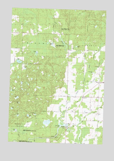
Bloomville, WI USGS Topographic Map
Click on map above to begin viewing in our Map Viewer.

This topographic map contains these locations and features:
Feature Name Type Latitude Longitude GNIS ID View Map
0.9 ReservoirReservoirN45.3600°W89.5168°1793577View Map
Allen LakeLakeN45.3425°W89.5704°1560776View Map
Anderson LakeLakeN45.2760°W89.5901°1560857View Map
Anient LakeLakeN45.2912°W89.6148°1560875View Map
Axen Lake School (historical)SchoolN45.3305°W89.5485°1964287View Map
Big Hay Meadow CreekStreamN45.2652°W89.5468°1561728View Map
BloomvillePopulated PlaceN45.2933°W89.5276°1561937View Map
Bloomville ChurchChurchN45.2933°W89.5490°1561938View Map
Copper LakeLakeN45.3251°W89.6138°1563392View Map
Doering E12.129 DamDamN45.3600°W89.5168°1793576View Map
Drew School (historical)SchoolN45.2936°W89.5490°1964293View Map
Fox LakeLakeN45.2810°W89.6215°1565216View Map
Hart LakeLakeN45.2866°W89.6121°1566103View Map
Hay Meadow County ParkParkN45.2655°W89.5496°1838341View Map
Henson LakeLakeN45.2994°W89.6086°1566312View Map
Kings Springs State Public Fishery AreaParkN45.3416°W89.5518°1838346View Map
Kippenberg CreekStreamN45.3461°W89.5001°1567528View Map
Lincoln County LandfillLocaleN45.2892°W89.6044°2635478View Map
Lokemoen LakeLakeN45.3185°W89.6055°1568500View Map
Luecks LakeLakeN45.3336°W89.5908°1568797View Map
Luther Memorial CemeteryCemeteryN45.3225°W89.5073°1838353View Map
Manacke CreekStreamN45.2669°W89.5340°1568929View Map
Maple Grove School (historical)SchoolN45.2722°W89.5076°1964297View Map
North Branch Prairie RiverStreamN45.3016°W89.5332°1570394View Map
Oak LakeLakeN45.2747°W89.6131°1570657View Map
Pays Springs State Public Fishery AreaParkN45.3564°W89.5643°1838371View Map
Prairie Dell County ParkParkN45.2564°W89.5626°1838373View Map
Prairie Dell DamDamN45.2561°W89.5626°1571872View Map
Prairie Dell PondReservoirN45.2665°W89.5545°1571873View Map
Prairie Dells Dam (historical)DamN45.2558°W89.5626°1791696View Map
Prairie Dells Pond 179ReservoirN45.2566°W89.5635°1791697View Map
Saint Johns CemeteryCemeteryN45.2783°W89.5073°1573069View Map
Spring LakeLakeN45.2605°W89.6152°1574670View Map
Spring Lake State Public Hunting and Fishing AreaParkN45.2611°W89.6126°1838406View Map
Swiss LakeLakeN45.2748°W89.5997°1575197View Map
Town of BirchCivilN45.3373°W89.6106°1582810View Map
Town of SchleyCivilN45.2500°W89.5076°1584110View Map
Wedlers PondReservoirN45.3407°W89.5385°1576394View Map

Note: Coordinates in the location and feature list above are referenced to NAD83 datum.


Copyright (C) 2008-2025 Ryan Niemi / Sunset Dynamics ... All Rights Reserved