TopoQuest Logo
Do you find TopoQuest useful?
Help keep TopoQuest running and adding new maps/features by donating!
Bitcoin:  19c7KJd3qBynnjoSw5npx9KScwjBe4ifkT
Litecoin:  LXs6TkuXGGXo1vDsWCkWVdjQX94eUKd6ui
Home View Maps Find Maps Find Places Resources & Links


Hartford, Arkansas Topographic Map

USGS Map Title: Hartford, AR
USGS Map MRC: 35094A4
DRG (GeoTIFF) Download: o35094a4.tif


Neighboring USGS Topographic Map Quads:


  Spiro, OK  
35094B5
 

  Hackett, AR  
35094B4
 

  Greenwood, AR  
35094B3
 

  Poteau East, OK  
35094A5
 

  Hartford, AR  
35094A4
 

  Huntington, AR  
35094A3
 

  Heavener, OK  
34094H5
 

  Bates, AR  
34094H4
 

  Cauthron, AR  
34094H3


Map MRC Location:

N36°
W95°
N36°
W94°
H8 H7 H6 H5 H4 H3 H2 H1
G8 G7 G6 G5 G4 G3 G2 G1
F8 F7 F6 F5 F4 F3 F2 F1
E8 E7 E6 E5 E4 E3 E2 E1
D8 D7 D6 D5 D4 D3 D2 D1
C8 C7 C6 C5 C4 C3 C2 C1
B8 B7 B6 B5 B4 B3 B2 B1
A8 A7 A6 A5 A4 A3 A2 A1
N35°
W95°
N35°
W94°

Hartford, AR USGS 1:24K Topographic Map Preview:
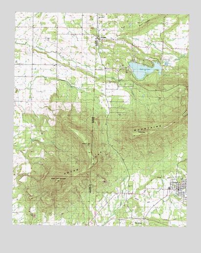
Hartford, AR USGS Topographic Map
Click on map above to begin viewing in our Map Viewer.

This topographic map contains these locations and features:
Feature Name Type Latitude Longitude GNIS ID View Map
Begum CemeteryCemeteryN35.0854°W94.4260°56702View Map
City of HartfordCivilN35.0237°W94.3805°2403809View Map
Clark CemeteryCemeteryN35.0748°W94.3960°56696View Map
Emert BranchStreamN35.0995°W94.3813°56699View Map
Hall CemeteryCemeteryN35.0950°W94.4992°1100094View Map
HartfordPopulated PlaceN35.0229°W94.3813°77137View Map
Hartford Elementary SchoolSchoolN35.0225°W94.3877°67227View Map
Hartford High SchoolSchoolN35.0235°W94.3880°67228View Map
Hartford Police DepartmentBuildingN35.0222°W94.3811°2118989View Map
Hartford Volunteer Fire DepartmentBuildingN35.0190°W94.3812°2116540View Map
Haw BranchStreamN35.0895°W94.3952°56698View Map
HillPopulated PlaceN35.0945°W94.4694°1100497View Map
Midland PeakSummitN35.0545°W94.4083°51942View Map
New Providence ChurchChurchN35.1220°W94.4408°56700View Map
Oklahoma PeakSummitN35.0473°W94.4472°1096211View Map
Pleasant Valley CemeteryCemeteryN35.0843°W94.4330°56701View Map
Red Yard CemeteryCemeteryN35.0237°W94.4177°56697View Map
Rock CreekStreamN35.0959°W94.4566°1100093View Map
Scott RidgeRidgeN35.1229°W94.4022°54646View Map
SlaytonvillePopulated PlaceN35.1107°W94.4386°58634View Map
Sugar Loaf LakeLakeN35.0922°W94.4070°1890163View Map
Sugar Loaf Lake DamDamN35.0918°W94.4058°80699View Map
Sugar Loaf MountainSummitN35.0262°W94.4683°1100961View Map
Sugar Loaf MountainsSummitN35.0262°W94.4683°67113View Map
Sugarloaf - Slaytonville Fire StationBuildingN35.0955°W94.4064°2117185View Map
Township of HartfordCivilN35.0039°W94.3921°69109View Map
Township of MississippiCivilN35.1107°W94.4049°69114View Map
West HartfordPopulated PlaceN35.0045°W94.4102°58851View Map

Note: Coordinates in the location and feature list above are referenced to NAD83 datum.


Copyright (C) 2008-2024 Ryan Niemi / Sunset Dynamics ... All Rights Reserved