TopoQuest Logo
Do you find TopoQuest useful?
Help keep TopoQuest running and adding new maps/features by donating!
Bitcoin:  19c7KJd3qBynnjoSw5npx9KScwjBe4ifkT
Litecoin:  LXs6TkuXGGXo1vDsWCkWVdjQX94eUKd6ui
Home View Maps Find Maps Find Places Resources & Links


Spiro, Oklahoma Topographic Map

USGS Map Title: Spiro, OK
USGS Map MRC: 35094B5
DRG (GeoTIFF) Download: o35094b5.tif


Neighboring USGS Topographic Map Quads:


  Muldrow SW, OK  
35094C6
 

  Fort Coffee, OK  
35094C5
 

  South Fort Smith, AR  
35094C4
 

  Panama, OK  
35094B6
 

  Spiro, OK  
35094B5
 

  Hackett, AR  
35094B4
 

  Poteau West, OK  
35094A6
 

  Poteau East, OK  
35094A5
 

  Hartford, AR  
35094A4


Map MRC Location:

N36°
W95°
N36°
W94°
H8 H7 H6 H5 H4 H3 H2 H1
G8 G7 G6 G5 G4 G3 G2 G1
F8 F7 F6 F5 F4 F3 F2 F1
E8 E7 E6 E5 E4 E3 E2 E1
D8 D7 D6 D5 D4 D3 D2 D1
C8 C7 C6 C5 C4 C3 C2 C1
B8 B7 B6 B5 B4 B3 B2 B1
A8 A7 A6 A5 A4 A3 A2 A1
N35°
W95°
N35°
W94°

Spiro, OK USGS 1:24K Topographic Map Preview:
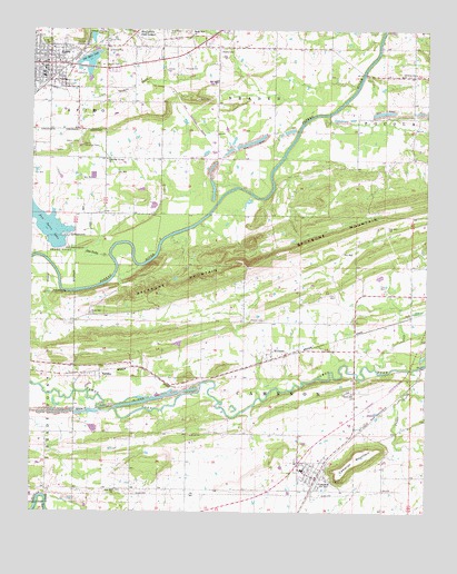
Spiro, OK USGS Topographic Map
Click on map above to begin viewing in our Map Viewer.

This topographic map contains these locations and features:
Feature Name Type Latitude Longitude GNIS ID View Map
CameronPopulated PlaceN35.1340°W94.5347°1090830View Map
Cameron Elementary SchoolSchoolN35.1358°W94.5393°1790586View Map
Cameron High SchoolSchoolN35.1361°W94.5393°1803878View Map
Cameron MountainSummitN35.1387°W94.5211°1090831View Map
Cedar CreekStreamN35.1620°W94.5047°1091094View Map
Christian Grove ChurchChurchN35.2387°W94.5083°1091344View Map
Emergency Medical Services of Le Flore County Station 5 SpiroBuildingN35.2370°W94.6152°2695944View Map
Fair Hill ChurchChurchN35.1307°W94.5983°1092684View Map
Fairhill CemeteryCemeteryN35.1305°W94.5946°2711776View Map
First Baptist ChurchChurchN35.2407°W94.6230°1810033View Map
French CemeteryCemeteryN35.1749°W94.5564°1093044View Map
Green Hill ChurchChurchN35.1559°W94.5233°1093376View Map
Greenhill CemeteryCemeteryN35.1565°W94.5249°2711782View Map
Hog Eye Volunteer Fire DepartmentBuildingN35.1740°W94.5229°2657355View Map
Holi-Tuska CreekStreamN35.1918°W94.6005°1093841View Map
Lakeview Baptist ChurchChurchN35.2412°W94.6177°1810034View Map
Murry Spur ChurchChurchN35.2487°W94.5741°1095714View Map
New Hope CemeteryCemeteryN35.2498°W94.5819°1095811View Map
New Spiro LakeReservoirN35.2004°W94.6217°1751285View Map
New Spiro Lake DamDamN35.1918°W94.6169°1751284View Map
Old Spiro LakeReservoirN35.2411°W94.6076°1096252View Map
Old Spiro Lake DamDamN35.2418°W94.6119°1750809View Map
Royal Oak CemeteryCemeteryN35.1765°W94.6058°2724228View Map
Royal Oak ChurchChurchN35.1768°W94.6063°1097515View Map
SkullyvillePopulated PlaceN35.2484°W94.5936°1098103View Map
SpiroPopulated PlaceN35.2412°W94.6199°1098363View Map
Spiro Fire DepartmentBuildingN35.2425°W94.6208°2656886View Map
Spiro Police DepartmentBuildingN35.2366°W94.6207°2757573View Map
TahonaPopulated PlaceN35.1615°W94.6033°1100873View Map
Town of CameronCivilN35.1351°W94.5359°2413153View Map
Town of SpiroCivilN35.2410°W94.6232°2413316View Map
Township of CameronCivilN35.1557°W94.5419°1824673View Map
United Methodist ChurchChurchN35.2412°W94.6213°1810035View Map
Wards CemeteryCemeteryN35.2445°W94.5649°1099362View Map
WilliamsPopulated PlaceN35.1648°W94.5486°1099838View Map

Note: Coordinates in the location and feature list above are referenced to NAD83 datum.


Copyright (C) 2008-2025 Ryan Niemi / Sunset Dynamics ... All Rights Reserved