TopoQuest Logo
Do you find TopoQuest useful?
Help keep TopoQuest running and adding new maps/features by donating!
Bitcoin:  19c7KJd3qBynnjoSw5npx9KScwjBe4ifkT
Litecoin:  LXs6TkuXGGXo1vDsWCkWVdjQX94eUKd6ui
Home View Maps Find Maps Find Places Resources & Links


Poteau East, Oklahoma Topographic Map

USGS Map Title: Poteau East, OK
USGS Map MRC: 35094A5
DRG (GeoTIFF) Download: o35094a5.tif


Neighboring USGS Topographic Map Quads:


  Panama, OK  
35094B6
 

  Spiro, OK  
35094B5
 

  Hackett, AR  
35094B4
 

  Poteau West, OK  
35094A6
 

  Poteau East, OK  
35094A5
 

  Hartford, AR  
35094A4
 

  Wister, OK  
34094H6
 

  Heavener, OK  
34094H5
 

  Bates, AR  
34094H4


Map MRC Location:

N36°
W95°
N36°
W94°
H8 H7 H6 H5 H4 H3 H2 H1
G8 G7 G6 G5 G4 G3 G2 G1
F8 F7 F6 F5 F4 F3 F2 F1
E8 E7 E6 E5 E4 E3 E2 E1
D8 D7 D6 D5 D4 D3 D2 D1
C8 C7 C6 C5 C4 C3 C2 C1
B8 B7 B6 B5 B4 B3 B2 B1
A8 A7 A6 A5 A4 A3 A2 A1
N35°
W95°
N35°
W94°

Poteau East, OK USGS 1:24K Topographic Map Preview:
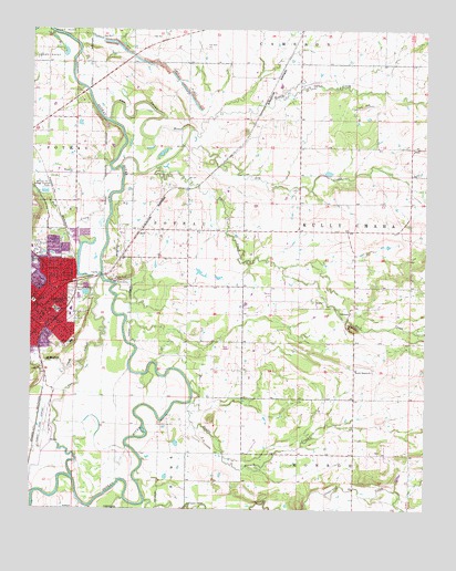
Poteau East, OK USGS Topographic Map
Click on map above to begin viewing in our Map Viewer.

This topographic map contains these locations and features:
Feature Name Type Latitude Longitude GNIS ID View Map
Cameron DivisionCivilN35.0838°W94.5327°1937658View Map
Church of ChristChurchN35.0568°W94.6211°1809828View Map
Church of the NazareneChurchN35.0515°W94.6205°1809830View Map
Cowskin CreekStreamN35.0007°W94.5069°1101371View Map
Double Branch ChurchChurchN35.0365°W94.5222°1092147View Map
Double Branch CreekStreamN35.0312°W94.5741°1092148View Map
Eastern Oklahoma Medical CenterHospitalN35.0435°W94.6124°1092457View Map
First Baptist ChurchChurchN35.0523°W94.6216°1809832View Map
First Christian ChurchChurchN35.0534°W94.6205°1809833View Map
First United Methodist ChurchChurchN35.0520°W94.6219°1809835View Map
Gap CreekStreamN35.0954°W94.5769°1093100View Map
GilmorePopulated PlaceN35.0529°W94.5230°1100450View Map
Kingdom Hall Jehovahs WitnessesChurchN35.0548°W94.6191°1809836View Map
Le Flore County Detention CenterBuildingN35.0545°W94.6242°2757813View Map
Le Flore County Sheriff's OfficeBuildingN35.0547°W94.6240°2757662View Map
Lost Poteau RiverStreamN35.1012°W94.6008°1095012View Map
McMurtrey CreekStreamN35.0382°W94.6091°1095276View Map
Nail CreekStreamN35.0893°W94.5861°1095740View Map
Nail CreekStreamN35.0895°W94.5858°1100091View Map
NeffPopulated PlaceN35.0729°W94.5919°1100119View Map
Pansy Kidd Middle SchoolSchoolN35.0518°W94.6173°1093985View Map
Polk CreekStreamN35.0807°W94.6008°1096807View Map
PoteauPopulated PlaceN35.0537°W94.6236°1096874View Map
Poteau DivisionCivilN35.0537°W94.6156°1937829View Map
Poteau Fire Department Station 1 HeadquartersBuildingN35.0531°W94.6226°2657160View Map
Poteau Police DepartmentBuildingN35.0535°W94.6224°2757434View Map
Presbyterian ChurchChurchN35.0537°W94.6202°1809839View Map
Reorganized Church of Jesus Christ of Latter Day SaintsChurchN35.0615°W94.6194°1809840View Map
Riddle CreekStreamN35.0987°W94.5749°1097198View Map
Robert S Kerr AirportAirportN35.0196°W94.6190°1102640View Map
Rodman SchoolSchoolN35.0570°W94.6224°1097385View Map
Sugarloaf CreekStreamN35.0020°W94.5886°70399View Map
The Church of Jesus Christ of Latter Day SaintsChurchN35.0732°W94.6208°1809829View Map
The CutoffStreamN35.0604°W94.6033°1098832View Map
Town CreekStreamN35.0562°W94.6052°1089506View Map
Township of Kully ChahaCivilN35.0834°W94.5336°1102852View Map
Vaughn CemeteryCemeteryN35.0372°W94.5220°2711805View Map

Note: Coordinates in the location and feature list above are referenced to NAD83 datum.


Copyright (C) 2008-2024 Ryan Niemi / Sunset Dynamics ... All Rights Reserved