TopoQuest Logo
Do you find TopoQuest useful?
Help keep TopoQuest running and adding new maps/features by donating!
Bitcoin:  19c7KJd3qBynnjoSw5npx9KScwjBe4ifkT
Litecoin:  LXs6TkuXGGXo1vDsWCkWVdjQX94eUKd6ui
Home View Maps Find Maps Find Places Resources & Links


Avery, Idaho Topographic Map

USGS Map Title: Avery, ID
USGS Map MRC: 47115C7
DRG (GeoTIFF) Download: o47115c7.tif


Neighboring USGS Topographic Map Quads:


  Wallace, ID  
47115D8
 

  Mullan, ID  
47115D7
 

  Lookout Pass, MT  
47115D6
 

  Mastodon Mountain, ID  
47115C8
 

  Avery, ID  
47115C7
 

  Shefoot Mountain, ID  
47115C6
 

  Hoyt Mountain, ID  
47115B8
 

  Fishhook Creek, ID  
47115B7
 

  Three Sisters, ID  
47115B6


Map MRC Location:

N48°
W116°
N48°
W115°
H8 H7 H6 H5 H4 H3 H2 H1
G8 G7 G6 G5 G4 G3 G2 G1
F8 F7 F6 F5 F4 F3 F2 F1
E8 E7 E6 E5 E4 E3 E2 E1
D8 D7 D6 D5 D4 D3 D2 D1
C8 C7 C6 C5 C4 C3 C2 C1
B8 B7 B6 B5 B4 B3 B2 B1
A8 A7 A6 A5 A4 A3 A2 A1
N47°
W116°
N47°
W115°

Avery, ID USGS 1:24K Topographic Map Preview:
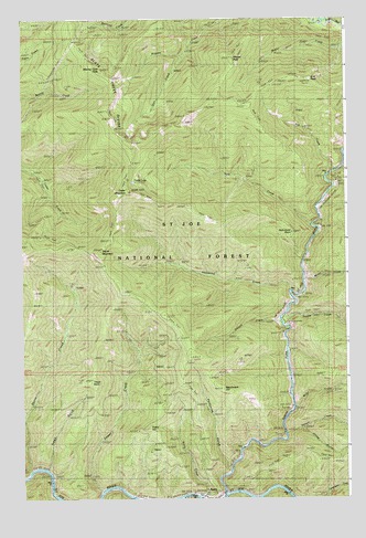
Avery, ID USGS Topographic Map
Click on map above to begin viewing in our Map Viewer.

This topographic map contains these locations and features:
Feature Name Type Latitude Longitude GNIS ID View Map
Arid PeakSummitN47.3588°W115.7638°376708View Map
Arid Ridge TrailTrailN47.3519°W115.8002°398582View Map
AveryPopulated PlaceN47.2505°W115.8052°396059View Map
Avery CreekStreamN47.2527°W115.8052°376781View Map
Avery Elementary - Junior High SchoolSchoolN47.2505°W115.8127°401408View Map
Avery Guard StationLocaleN47.2519°W115.8054°399362View Map
Avery HillSummitN47.2683°W115.8265°376783View Map
Avery Post OfficePost OfficeN47.2508°W115.8072°2781793View Map
Benchmark HillSummitN47.2785°W115.7988°377353View Map
Big Dick CreekStreamN47.3358°W115.7518°377503View Map
Cedar LakeLakeN47.3327°W115.8323°379109View Map
Cedar MountainRidgeN47.3502°W115.8424°379110View Map
Cedar MountainSummitN47.3541°W115.8427°379112View Map
Cedar Mountain TrailTrailN47.3044°W115.8382°379114View Map
Fortynine GulchValleyN47.2577°W115.7968°381948View Map
Glen CreekStreamN47.3652°W115.8132°382295View Map
Hammond CreekStreamN47.3035°W115.7718°382854View Map
Hammond PointSummitN47.3191°W115.7713°396606View Map
Jitney GulchValleyN47.2674°W115.7663°383924View Map
Kyle (historical)Populated PlaceN47.3280°W115.7577°396756View Map
Kyle CreekStreamN47.3208°W115.7640°384322View Map
Kyle Creek TrailTrailN47.3380°W115.7690°398586View Map
Marcus Cook PeakSummitN47.3616°W115.8454°396850View Map
Miller CreekStreamN47.2735°W115.7707°386971View Map
Motor CreekStreamN47.3069°W115.7663°387277View Map
Mozier PeakSummitN47.3646°W115.7943°387317View Map
Nelson CreekStreamN47.2663°W115.7738°387514View Map
North Fork Saint Joe RiverStreamN47.2508°W115.7968°387770View Map
Rye CreekStreamN47.3355°W115.7549°389754View Map
Setzer CreekStreamN47.2519°W115.8446°390114View Map
StetsonPopulated PlaceN47.2849°W115.7743°397211View Map
Stetson CreekStreamN47.2958°W115.7760°391434View Map
Storm CreekStreamN47.2569°W115.8729°391500View Map
Storm MountainSummitN47.3141°W115.8452°391505View Map
Telichpah CampgroundLocaleN47.2960°W115.7754°400410View Map
Telichpah CreekStreamN47.2977°W115.7746°391300View Map
Theriault CreekStreamN47.2505°W115.8127°391992View Map
Trego GulchValleyN47.2585°W115.8657°392376View Map
Trego PointSummitN47.2802°W115.8490°397268View Map
Trego Point Trail (historical)TrailN47.2938°W115.8446°398588View Map

Note: Coordinates in the location and feature list above are referenced to NAD83 datum.


Copyright (C) 2008-2024 Ryan Niemi / Sunset Dynamics ... All Rights Reserved