TopoQuest Logo
Do you find TopoQuest useful?
Help keep TopoQuest running and adding new maps/features by donating!
Bitcoin:  19c7KJd3qBynnjoSw5npx9KScwjBe4ifkT
Litecoin:  LXs6TkuXGGXo1vDsWCkWVdjQX94eUKd6ui
Home View Maps Find Maps Find Places Resources & Links


Hartland, Michigan Topographic Map

USGS Map Title: Hartland, MI
USGS Map MRC: 42083F7
DRG (GeoTIFF) Download: o42083f7.tif


Neighboring USGS Topographic Map Quads:


  Byron, MI  
42083G8
 

  Linden, MI  
42083G7
 

  Fenton, MI  
42083G6
 

  Oak Grove, MI  
42083F8
 

  Hartland, MI  
42083F7
 

  West Highland, MI  
42083F6
 

  Howell, MI  
42083E8
 

  Brighton, MI  
42083E7
 

  Kent Lake, MI  
42083E6


Map MRC Location:

N43°
W84°
N43°
W83°
H8 H7 H6 H5 H4 H3 H2 H1
G8 G7 G6 G5 G4 G3 G2 G1
F8 F7 F6 F5 F4 F3 F2 F1
E8 E7 E6 E5 E4 E3 E2 E1
D8 D7 D6 D5 D4 D3 D2 D1
C8 C7 C6 C5 C4 C3 C2 C1
B8 B7 B6 B5 B4 B3 B2 B1
A8 A7 A6 A5 A4 A3 A2 A1
N42°
W84°
N42°
W83°

Hartland, MI USGS 1:24K Topographic Map Preview:
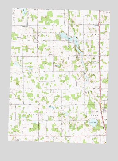
Hartland, MI USGS Topographic Map
Click on map above to begin viewing in our Map Viewer.

This topographic map contains these locations and features:
Feature Name Type Latitude Longitude GNIS ID View Map
Barris LakeLakeN42.6954°W83.8613°1617078View Map
Catholic Cemetery (historical)CemeteryN42.6464°W83.7922°2631036View Map
Charyl Stockwell AcademySchoolN42.6339°W83.7647°2630355View Map
Church LakeLakeN42.6477°W83.8560°623301View Map
Creekside Elementary SchoolSchoolN42.6545°W83.7501°2630358View Map
Cromaine LibraryBuildingN42.6586°W83.7542°2630373View Map
Deerfield CenterPopulated PlaceN42.7336°W83.8622°624497View Map
Deerfield Center CemeteryCemeteryN42.7224°W83.8619°624498View Map
Fausett LakeReservoirN42.6972°W83.8671°1617010View Map
Fellowship Bible ChurchChurchN42.6389°W83.7508°2630371View Map
Florence B Deering Museum Historical MarkerParkN42.6553°W83.7545°2630861View Map
Hardy ChurchChurchN42.6300°W83.8261°627789View Map
HartlandPopulated PlaceN42.6567°W83.7530°627882View Map
Hartland Burying Ground Historical MarkerParkN42.6583°W83.7547°2630865View Map
Hartland Deerfield Authority Fire Station 61 Main StationBuildingN42.6494°W83.7545°2630370View Map
Hartland Deerfield Authority Fire Station 62BuildingN42.6925°W83.7621°2620027View Map
Hartland Deerfield Fire Station 63BuildingN42.7330°W83.8628°2620032View Map
Hartland Middle SchoolSchoolN42.6513°W83.7524°2630367View Map
Hartland Music Hall Historical MarkerParkN42.6572°W83.7546°2630866View Map
Hartland Post OfficePost OfficeN42.6553°W83.7544°2630363View Map
Hartland United Methodist ChurchChurchN42.6564°W83.7528°2630364View Map
Hartland Village CemeteryCemeteryN42.6586°W83.7553°2631053View Map
Interchange 70CrossingN42.6769°W83.7597°2630832View Map
Interchange 75CrossingN42.7372°W83.7639°2630833View Map
Ironwood Golf CourseLocaleN42.6283°W83.8181°2630359View Map
Lake WaldenLakeN42.6450°W83.7674°622058View Map
Lamb LakeLakeN42.7500°W83.8652°630087View Map
Life Christian ChurchChurchN42.6303°W83.8528°2630285View Map
Livingston County Michigan Emergency Medical Services Department Station 104BuildingN42.6925°W83.7621°2661900View Map
Logan LakesLakeN42.6258°W83.8602°630883View Map
Louise LakeLakeN42.7470°W83.8598°631131View Map
Madison Post Office (historical)Post OfficeN42.7194°W83.8611°2631008View Map
Majestic at Lake Walden Golf CourseLocaleN42.6408°W83.7700°2630356View Map
Neff LakeLakeN42.6578°W83.8211°633259View Map
Oceola Center Post Office (historical)Post OfficeN42.6306°W83.8264°2631001View Map
ParshallvillePopulated PlaceN42.6920°W83.7822°634431View Map
Parshallville CemeteryCemeteryN42.6897°W83.7822°2631054View Map
Parshallville Post Office (historical)Post OfficeN42.6919°W83.7822°2631000View Map
Payne LakeLakeN42.6972°W83.8139°634500View Map
Riddle CemeteryCemeteryN42.6500°W83.8372°2631029View Map
Saint Augustine ChurchChurchN42.7061°W83.8225°636557View Map
Saint Augustine's Catholic CemeteryCemeteryN42.7061°W83.8208°2631055View Map
Saint John ChurchChurchN42.6306°W83.7977°636699View Map
Saint John the Baptist Catholic Church Historical MarkerParkN42.6309°W83.7975°2630876View Map
Saint John's Catholic Church CemeteryCemeteryN42.6305°W83.7975°2631052View Map
Shannon LakeReservoirN42.7197°W83.7965°637659View Map
Smith CemeteryCemeteryN42.6725°W83.7791°638132View Map
Tom Walker's Grist Mill Historical MarkerParkN42.6910°W83.7819°2630880View Map
Township of DeerfieldCivilN42.7356°W83.8620°1626171View Map
Township of OceolaCivilN42.6454°W83.8565°1626835View Map
Trollman's FieldAirportN42.7421°W83.7508°1623895View Map
Tyrone Hills Golf ClubLocaleN42.7359°W83.7661°1623677View Map
Victory Baptist ChurchChurchN42.6575°W83.7528°2630365View Map

Note: Coordinates in the location and feature list above are referenced to NAD83 datum.


Copyright (C) 2008-2025 Ryan Niemi / Sunset Dynamics ... All Rights Reserved