TopoQuest Logo
Do you find TopoQuest useful?
Help keep TopoQuest running and adding new maps/features by donating!
Bitcoin:  19c7KJd3qBynnjoSw5npx9KScwjBe4ifkT
Litecoin:  LXs6TkuXGGXo1vDsWCkWVdjQX94eUKd6ui
Home View Maps Find Maps Find Places Resources & Links


Linden, Michigan Topographic Map

USGS Map Title: Linden, MI
USGS Map MRC: 42083G7
DRG (GeoTIFF) Download: o42083g7.tif


Neighboring USGS Topographic Map Quads:


  Durand, MI  
42083H8
 

  Swartz Creek, MI  
42083H7
 

  Flint South, MI  
42083H6
 

  Byron, MI  
42083G8
 

  Linden, MI  
42083G7
 

  Fenton, MI  
42083G6
 

  Oak Grove, MI  
42083F8
 

  Hartland, MI  
42083F7
 

  West Highland, MI  
42083F6


Map MRC Location:

N43°
W84°
N43°
W83°
H8 H7 H6 H5 H4 H3 H2 H1
G8 G7 G6 G5 G4 G3 G2 G1
F8 F7 F6 F5 F4 F3 F2 F1
E8 E7 E6 E5 E4 E3 E2 E1
D8 D7 D6 D5 D4 D3 D2 D1
C8 C7 C6 C5 C4 C3 C2 C1
B8 B7 B6 B5 B4 B3 B2 B1
A8 A7 A6 A5 A4 A3 A2 A1
N42°
W84°
N42°
W83°

Linden, MI USGS 1:24K Topographic Map Preview:
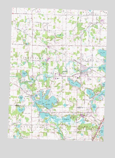
Linden, MI USGS Topographic Map
Click on map above to begin viewing in our Map Viewer.

This topographic map contains these locations and features:
Feature Name Type Latitude Longitude GNIS ID View Map
ArgentinePopulated PlaceN42.7914°W83.8463°620210View Map
Argentine CemeteryCemeteryN42.7972°W83.8369°620211View Map
Argentine Census Designated PlaceCensusN42.7905°W83.8356°2393318View Map
Argentine Church of the NazareneChurchN42.7892°W83.8464°2611682View Map
Argentine Elementary SchoolSchoolN42.7922°W83.8411°2611637View Map
Argentine Post Office (historical)Post OfficeN42.7914°W83.8464°2585862View Map
Argentine Township Fire and RescueBuildingN42.7919°W83.8457°2619898View Map
Argentine Township Police DepartmentBuildingN42.7945°W83.8381°2737372View Map
Argentine United Methodist ChurchChurchN42.7914°W83.8475°2611681View Map
Bass LakeLakeN42.8071°W83.8459°620684View Map
Bennett LakeLakeN42.7717°W83.8202°621113View Map
Blue Gill IslandIslandN42.7834°W83.8255°621625View Map
Buckbee LakeLakeN42.7833°W83.8018°622184View Map
Byram LakeLakeN42.8045°W83.7902°622405View Map
Camp KiwanisLocaleN42.7945°W83.7602°622591View Map
Central SchoolSchoolN42.8089°W83.8130°623015View Map
Charter Township of FentonCivilN42.8336°W83.7528°1626276View Map
City of LindenCivilN42.8194°W83.7811°1626627View Map
Clough Hill CemeteryCemeteryN42.7581°W83.7850°623494View Map
Cole Field (historical)AirportN42.8723°W83.8408°1623909View Map
Coyote Preserve Golf ClubLocaleN42.7606°W83.7772°2585917View Map
Croft LakeLakeN42.8408°W83.8533°624076View Map
Fairview CemeteryCemeteryN42.8150°W83.7724°625768View Map
Faith Baptist ChurchChurchN42.8111°W83.7631°2611678View Map
Fenton Township Fire Department Ambulance Station 2BuildingN42.7895°W83.7707°2620241View Map
Heritage Hills ChurchChurchN42.7642°W83.7514°2585910View Map
Hoisington LakeLakeN42.7701°W83.7988°628403View Map
Hope Lutheran ChurchChurchN42.8072°W83.8183°2611676View Map
Interchange 77CrossingN42.7689°W83.7522°2630835View Map
Journey Assembly of God ChurchChurchN42.8086°W83.8431°2611675View Map
Kimball CemeteryCemeteryN42.8592°W83.7741°629673View Map
Lake Fenton High SchoolSchoolN42.8408°W83.7506°2611632View Map
LindenPopulated PlaceN42.8145°W83.7825°630496View Map
Linden City Fire DepartmentBuildingN42.8145°W83.7812°2619945View Map
Linden Elementary SchoolSchoolN42.8114°W83.7833°2611634View Map
Linden Family MedicineHospitalN42.8103°W83.8011°2611629View Map
Linden Free Methodist ChurchChurchN42.8333°W83.7833°2611674View Map
Linden High SchoolSchoolN42.8086°W83.8153°2611636View Map
Linden LibraryBuildingN42.8153°W83.7814°2611628View Map
Linden Middle SchoolSchoolN42.8097°W83.7861°2611635View Map
Linden Mills Historical MarkerParkN42.8155°W83.7812°2582605View Map
Linden ParkParkN42.8023°W83.7797°630500View Map
Linden Police DepartmentBuildingN42.8146°W83.7812°2737446View Map
Linden Post OfficePost OfficeN42.8133°W83.7806°2611626View Map
Linden Presbyterian ChurchChurchN42.8139°W83.7833°2611679View Map
Linden Presbyterian Church Historical MarkerParkN42.8147°W83.7826°2582606View Map
Linden StationLocaleN42.8244°W83.7861°2611631View Map
Lobdell LakeReservoirN42.7820°W83.8259°630848View Map
Loon LakeLakeN42.8346°W83.7533°631057View Map
Marl LakeLakeN42.7833°W83.7641°631587View Map
McCaslin LakeLakeN42.8119°W83.8562°631822View Map
McCollom DrainCanalN42.8617°W83.8644°631836View Map
Mud LakeLakeN42.8223°W83.8560°632946View Map
Mud LakeLakeN42.8495°W83.8125°632947View Map
Murray LakeLakeN42.7886°W83.8594°633152View Map
North Bay Harbor Club Mobile Home ParkPopulated PlaceN42.7744°W83.8192°2585918View Map
North Ore CreekStreamN42.8034°W83.8566°633618View Map
Otter LakeLakeN42.8220°W83.8298°634188View Map
Pine LakeLakeN42.7957°W83.7697°634960View Map
Pine Ridge Mobile Home ParkPopulated PlaceN42.7961°W83.8556°2611627View Map
Prices AirportAirportN42.8091°W83.7705°1624010View Map
Root LakeLakeN42.7618°W83.8609°636183View Map
Runyan CreekStreamN42.7686°W83.8097°636377View Map
Ryan LakeLakeN42.7776°W83.8590°636436View Map
Seventh-Day Adventist ChurchChurchN42.8103°W83.8067°2611677View Map
Shiawassee LakeLakeN42.8084°W83.8292°637790View Map
Softwater LakeLakeN42.7915°W83.8398°638233View Map
Spring Meadows Country ClubLocaleN42.8306°W83.7772°2611633View Map
Stage IslandIslandN42.7848°W83.8316°638700View Map
Stan Nowiki Airport (historical)AirportN42.7945°W83.8497°1623782View Map
Stearns LakeLakeN42.7687°W83.7779°638768View Map
Tall Timber CampLocaleN42.7517°W83.8555°1614549View Map
Township of ArgentineCivilN42.8254°W83.8659°1625847View Map
Tupper LakeLakeN42.8196°W83.7575°1615169View Map
Tyrone Memory Gardens a CemeteryCemeteryN42.7705°W83.7599°626646View Map
United Methodist Church of LindenChurchN42.8136°W83.7819°2611680View Map

Note: Coordinates in the location and feature list above are referenced to NAD83 datum.


Copyright (C) 2008-2024 Ryan Niemi / Sunset Dynamics ... All Rights Reserved