TopoQuest Logo
Do you find TopoQuest useful?
Help keep TopoQuest running and adding new maps/features by donating!
Bitcoin:  19c7KJd3qBynnjoSw5npx9KScwjBe4ifkT
Litecoin:  LXs6TkuXGGXo1vDsWCkWVdjQX94eUKd6ui
Home View Maps Find Maps Find Places Resources & Links


Avis, New Mexico Topographic Map

USGS Map Title: Avis, NM
USGS Map MRC: 32105F4
DRG (GeoTIFF) Download: o32105f4.tif


Neighboring USGS Topographic Map Quads:


  Sacramento, NM  
32105G5
 

  Woodson Canyon, NM  
32105G4
 

  Robertson Canyon, NM  
32105G3
 

  Bear Spring, NM  
32105F5
 

  Avis, NM  
32105F4
 

  Chimney Lake, NM  
32105F3
 

  Surveyors Canyon, NM  
32105E5
 

  Pinon, NM  
32105E4
 

  Cornucopia Canyon, NM  
32105E3


Map MRC Location:

N33°
W106°
N33°
W105°
H8 H7 H6 H5 H4 H3 H2 H1
G8 G7 G6 G5 G4 G3 G2 G1
F8 F7 F6 F5 F4 F3 F2 F1
E8 E7 E6 E5 E4 E3 E2 E1
D8 D7 D6 D5 D4 D3 D2 D1
C8 C7 C6 C5 C4 C3 C2 C1
B8 B7 B6 B5 B4 B3 B2 B1
A8 A7 A6 A5 A4 A3 A2 A1
N32°
W106°
N32°
W105°

Avis, NM USGS 1:24K Topographic Map Preview:
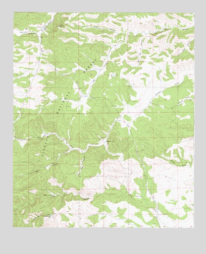
Avis, NM USGS Topographic Map
Click on map above to begin viewing in our Map Viewer.

This topographic map contains these locations and features:
Feature Name Type Latitude Longitude GNIS ID View Map
AvisPopulated PlaceN32.7004°W105.4547°903468View Map
Avis CemeteryCemeteryN32.6954°W105.4630°903469View Map
Avis Post Office (historical)Post OfficeN32.7004°W105.4547°937458View Map
Behringer TankReservoirN32.6315°W105.4730°909056View Map
Bell RanchLocaleN32.7415°W105.4808°903735View Map
Bluewater Lookout TowerTowerN32.7418°W105.4689°928883View Map
Brooks WellWellN32.6301°W105.4541°913366View Map
Creek TankReservoirN32.6639°W105.4249°913365View Map
Daugharty TankReservoirN32.6756°W105.4366°905610View Map
Elk CanyonValleyN32.6707°W105.4594°906118View Map
Godley TankReservoirN32.7470°W105.4216°913390View Map
Hilton CanyonValleyN32.7390°W105.4200°906989View Map
Ivans TankReservoirN32.6772°W105.4608°913363View Map
Lardhole TankReservoirN32.7191°W105.4003°913392View Map
Lick CanyonValleyN32.6457°W105.4200°907948View Map
Little TankReservoirN32.7423°W105.3916°913391View Map
Lower Lick TankReservoirN32.6438°W105.4719°908278View Map
New TankReservoirN32.6567°W105.4415°913364View Map
Piņon CemeteryCemeteryN32.6252°W105.3865°909715View Map
Piņon TankReservoirN32.6433°W105.4107°909721View Map
Prairie Dog CanyonValleyN32.6684°W105.4505°909837View Map
Railsplitter Number One TankReservoirN32.7470°W105.4501°913389View Map
Salt Box CanyonValleyN32.7373°W105.4086°910570View Map

Note: Coordinates in the location and feature list above are referenced to NAD83 datum.


Copyright (C) 2008-2024 Ryan Niemi / Sunset Dynamics ... All Rights Reserved