TopoQuest Logo
Do you find TopoQuest useful?
Help keep TopoQuest running and adding new maps/features by donating!
Bitcoin:  19c7KJd3qBynnjoSw5npx9KScwjBe4ifkT
Litecoin:  LXs6TkuXGGXo1vDsWCkWVdjQX94eUKd6ui
Home View Maps Find Maps Find Places Resources & Links


Woodson Canyon, New Mexico Topographic Map

USGS Map Title: Woodson Canyon, NM
USGS Map MRC: 32105G4
DRG (GeoTIFF) Download: o32105g4.tif


Neighboring USGS Topographic Map Quads:


  Harvey Ranch, NM  
32105H5
 

  Mayhill, NM  
32105H4
 

  Elk, NM  
32105H3
 

  Sacramento, NM  
32105G5
 

  Woodson Canyon, NM  
32105G4
 

  Robertson Canyon, NM  
32105G3
 

  Bear Spring, NM  
32105F5
 

  Avis, NM  
32105F4
 

  Chimney Lake, NM  
32105F3


Map MRC Location:

N33°
W106°
N33°
W105°
H8 H7 H6 H5 H4 H3 H2 H1
G8 G7 G6 G5 G4 G3 G2 G1
F8 F7 F6 F5 F4 F3 F2 F1
E8 E7 E6 E5 E4 E3 E2 E1
D8 D7 D6 D5 D4 D3 D2 D1
C8 C7 C6 C5 C4 C3 C2 C1
B8 B7 B6 B5 B4 B3 B2 B1
A8 A7 A6 A5 A4 A3 A2 A1
N32°
W106°
N32°
W105°

Woodson Canyon, NM USGS 1:24K Topographic Map Preview:
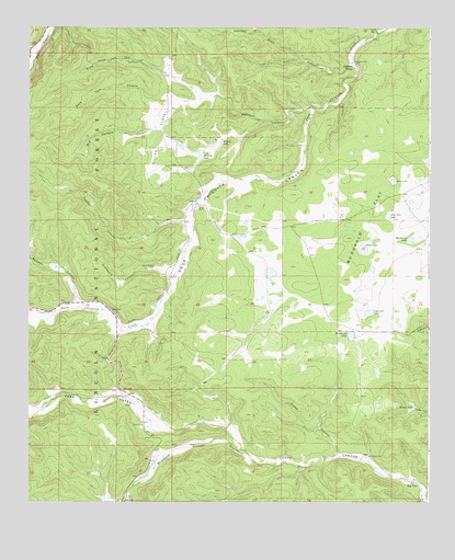
Woodson Canyon, NM USGS Topographic Map
Click on map above to begin viewing in our Map Viewer.

This topographic map contains these locations and features:
Feature Name Type Latitude Longitude GNIS ID View Map
Allen LakeLakeN32.8169°W105.3959°903099View Map
Barkley LakeLakeN32.8411°W105.4468°903565View Map
Bell TankReservoirN32.7678°W105.4836°913134View Map
Bible CanyonValleyN32.8570°W105.4422°903772View Map
Bluewater CanyonValleyN32.7640°W105.4341°903961View Map
Bud Holland CanyonValleyN32.8570°W105.4422°904157View Map
Cantwell LakeLakeN32.7997°W105.3941°904734View Map
CCC TankReservoirN32.8328°W105.4914°913356View Map
Covel LakeLakeN32.8347°W105.3866°905443View Map
Dela Van LakeLakeN32.8252°W105.3882°905713View Map
Dougherty WellWellN32.7623°W105.3944°905841View Map
Ernest WellWellN32.8437°W105.4447°936810View Map
Flume CanyonValleyN32.7620°W105.4036°906310View Map
Graveyard CanyonValleyN32.8109°W105.4572°906720View Map
Graveyard TankReservoirN32.8114°W105.4617°913360View Map
Hackberry LakeLakeN32.8186°W105.3811°906803View Map
Hunter CanyonValleyN32.8734°W105.3916°907168View Map
Key TankReservoirN32.7545°W105.3783°907548View Map
Lewis RanchLocaleN32.8279°W105.4458°907943View Map
Little TankReservoirN32.8285°W105.4804°913357View Map
Little TankReservoirN32.7658°W105.4386°913135View Map
Lower Snow TankReservoirN32.8660°W105.4207°913362View Map
Lusk CemeteryCemeteryN32.8120°W105.4611°903005View Map
McDonald FlatFlatN32.8220°W105.3933°908511View Map
McDonald LakeLakeN32.7939°W105.3995°908512View Map
McEwan CanyonValleyN32.8020°W105.4836°908514View Map
Middle TankReservoirN32.7750°W105.3799°908714View Map
Miller FlatsFlatN32.8482°W105.4594°908748View Map
Miller WellWellN32.8665°W105.4639°1987539View Map
Perk CanyonValleyN32.7643°W105.4339°909573View Map
Prather CanyonValleyN32.8248°W105.4519°909842View Map
Prather TankReservoirN32.8215°W105.4603°913361View Map
Railsplitter Tank Number TwoReservoirN32.7528°W105.4499°913387View Map
Reilsplitter Tank Number ThreeReservoirN32.7520°W105.4355°913388View Map
Rock Draw TankReservoirN32.8562°W105.4728°913354View Map
Rock Tank CanyonValleyN32.8565°W105.4539°910397View Map
Schoolhouse TankReservoirN32.8293°W105.4590°913358View Map
Section 24 TankReservoirN32.8195°W105.4637°913359View Map
Section Eleven TankReservoirN32.8425°W105.4849°913355View Map
Snow CanyonValleyN32.8659°W105.4000°911173View Map
Snow TankReservoirN32.8742°W105.4370°911183View Map
Stephens TanksReservoirN32.8645°W105.3989°911406View Map
Stephens WellWellN32.8659°W105.3986°911407View Map
Wilson LakeLakeN32.8450°W105.4403°912432View Map
Woodson CanyonValleyN32.8532°W105.4108°912497View Map

Note: Coordinates in the location and feature list above are referenced to NAD83 datum.


Copyright (C) 2008-2025 Ryan Niemi / Sunset Dynamics ... All Rights Reserved